Khumalag elevation
Khumalag (North Ossetia), Russia elevation is 441 meters and Khumalag elevation in feet is 1447 ft above sea level [src 1]. Khumalag is a populated place (feature code) with elevation that is 242 meters (794 ft) bigger than average city elevation in Russia.
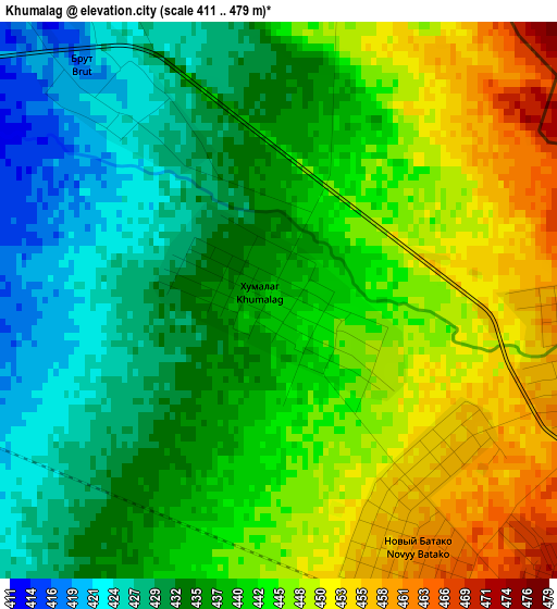
Below is the Elevation map of Khumalag, which displays elevation range with different colors. Scale of the first map is from 411 to 479 m (1348 to 1572 ft) with average elevation of 439.7 meters (=1443 ft) [note 1]
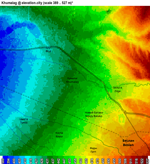
These maps also provides idea of topography and contour of this city, they are displayed at different zoom levels. More info about maps, scale and edge coordinates you can find below images.
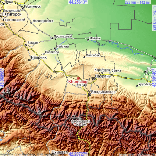
| \ | Map #1 | Map #2 | Topo.Map |
| Scale [m] | 411..479 m | 389..527 m | × |
| Scale [ft] | 1348..1572 ft | 1276..1729 ft | × |
| Average | 439.7 m = 1443 ft | 446.8 m = 1466 ft | × |
| Width | 7.12 km = 4.4 mi | 14.24 km = 8.8 mi | 227.8 km = 141.5 mi |
| Height | 7.12 km = 4.4 mi | 14.24 km = 8.8 mi | 227.8 km = 141.5 mi |
| ↑Max Latitude | 43.272315° | 43.304304° | 44.25613° |
| Latitude at center | 43.24031° | 43.24031° | 43.24031° |
| ↓Min Latitude | 43.208288° | 43.176249° | 42.20727° |
| ← Min Longitude | 44.431265° | 44.387319° | 43.06896° |
| Longitude center | 44.47521° | 44.47521° | 44.47521° |
| →Max Longitude | 44.519155° | 44.563101° | 45.88146° |
Nearby cities:
Cities around Khumalag sort by population:
• Nazran’ elevation 523 m
24.2 km,  93°
93°
• Beslan 494 m
7.7 km,  134°
134°
• Ardon 414 m
16.1 km,  244°
244°
• Kantyshevo 542 m
12.9 km,  95°
95°
• Nogir 623 m
22 km,  143°
143°
• Mikhaylovskoye 605 m
20.1 km, 140°
• Dalakovo 537 m
9.3 km, 91°
• Verkhniye Achaluki 473 m
21.5 km,  56°
56°
• Chermen 572 m
21.6 km,  117°
117°
• Arkhonskaya 534 m
14.8 km,  168°
168°
• Gizel’ 642 m
23.6 km,  160°
160°
• Kardzhin 367 m
15.4 km,  283°
283°
Multilingual:
 En español:
Khumalag elevación 441 m.
 En France:
Khumalag élévation 441 m.
 Auf Deutsch:
Khumalag höhe über dem Meeresspiegel ist 441 m.

Sources and notes:
- [note 1] Map square and city borders are not equal. Map elevation data is calculated only from area inside that square.
- [src 1] Elevation data from geonames database provided with same terms of usage.
- [src 2] The elevation map of Khumalag is generated using elevation data from NASA's 3 arcsec (90m) resolution SRTM data.
- [src 3] Base (background) map © OpenStreetMap contributors tiles are generated by Geofabrik and OpenTopoMap.
Copyright & License:
This Khumalag Elevation Map is licensed under CC BY-SA. You may reuse any part from this page, if you give a proper credit by linking to this URL:
 More info on terms of use page.