Khvalynsk elevation
Khvalynsk (Saratovskaya Oblast), Russia elevation is 39 meters and Khvalynsk elevation in feet is 128 ft above sea level [src 1]. Khvalynsk is a populated place (feature code) with elevation that is 160 meters (525 ft) smaller than average city elevation in Russia.
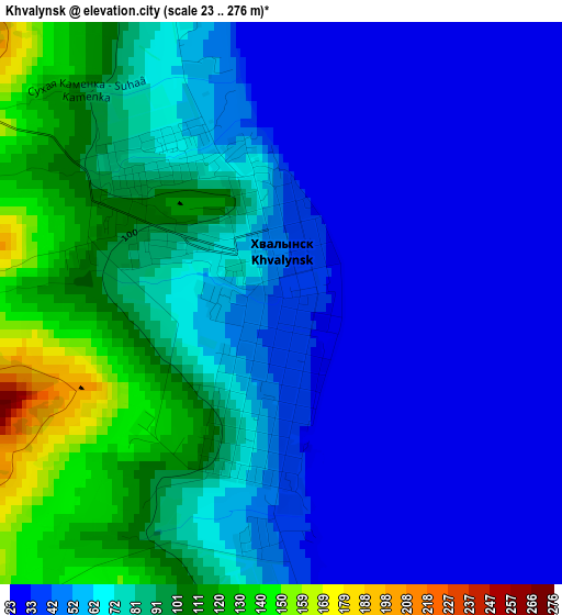
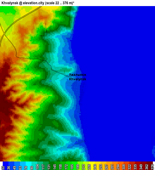
Below is the Elevation map of Khvalynsk, which displays elevation range with different colors. Scale of the first map is from 23 to 276 m (75 to 906 ft) with average elevation of 64.4 meters (=211 ft) [note 1]
These maps also provides idea of topography and contour of this city, they are displayed at different zoom levels. More info about maps, scale and edge coordinates you can find below images.
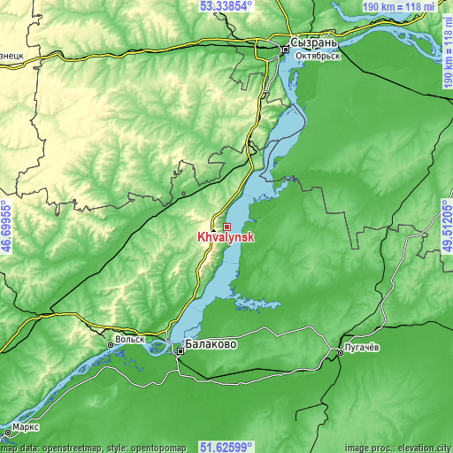
| \ | Map #1 | Map #2 | Topo.Map |
| Scale [m] | 23..276 m | 22..376 m | × |
| Scale [ft] | 75..906 ft | 72..1234 ft | × |
| Average | 64.4 m = 211 ft | 104.3 m = 342 ft | × |
| Width | 5.95 km = 3.7 mi | 11.9 km = 7.4 mi | 190.4 km = 118.3 mi |
| Height | 5.95 km = 3.7 mi | 11.9 km = 7.4 mi | 190.4 km = 118.3 mi |
| ↑Max Latitude | 52.51735° | 52.544083° | 53.33854° |
| Latitude at center | 52.4906° | 52.4906° | 52.4906° |
| ↓Min Latitude | 52.463834° | 52.437052° | 51.62599° |
| ← Min Longitude | 48.061855° | 48.017909° | 46.69955° |
| Longitude center | 48.1058° | 48.1058° | 48.1058° |
| →Max Longitude | 48.149745° | 48.193691° | 49.51205° |
Nearby cities:
Cities around Khvalynsk sort by population:
• Balakovo elevation 28 m
55.5 km,  201°
201°
• Vol’sk 83 m
69.9 km,  224°
224°
• Pugachev 40 m
71.2 km,  138°
138°
• Staraya Kulatka 109 m
42.2 km,  308°
308°
• Pavlovka 176 m
68.9 km,  288°
288°
• Dukhovnitskoye 35 m
7.4 km,  96°
96°
• Khvorostyanka 43 m
59.2 km,  77°
77°
• Radishchevo 106 m
43.3 km,  339°
339°
• Cherkasskoye 89 m
61 km,  263°
263°
• Alekseyevka 34 m
21.2 km,  194°
194°
• Tersa 27 m
59.2 km, 220°
• Kormëzhka 24 m
65.9 km, 185°
Multilingual:
 En español:
Jvalynsk elevación 39 m.
 En France:
Khvalynsk élévation 39 m.
 Auf Deutsch:
Chwalynsk höhe über dem Meeresspiegel ist 39 m.

Sources and notes:
- [note 1] Map square and city borders are not equal. Map elevation data is calculated only from area inside that square.
- [src 1] Elevation data from geonames database provided with same terms of usage.
- [src 2] The elevation map of Khvalynsk is generated using elevation data from NASA's 3 arcsec (90m) resolution SRTM data.
- [src 3] Base (background) map © OpenStreetMap contributors tiles are generated by Geofabrik and OpenTopoMap.
Copyright & License:
This Khvalynsk Elevation Map is licensed under CC BY-SA. You may reuse any part from this page, if you give a proper credit by linking to this URL:
 More info on terms of use page.