Staraya Kulatka elevation
Staraya Kulatka (Ulyanovsk), Russia elevation is 109 meters and Staraya Kulatka elevation in feet is 358 ft above sea level [src 1]. Staraya Kulatka is a populated place (feature code) with elevation that is 90 meters (295 ft) smaller than average city elevation in Russia.
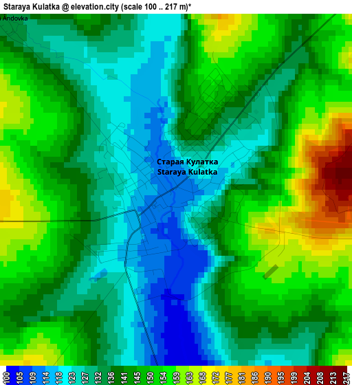
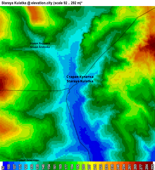
Below is the Elevation map of Staraya Kulatka, which displays elevation range with different colors. Scale of the first map is from 100 to 217 m (328 to 712 ft) with average elevation of 139.9 meters (=459 ft) [note 1]
These maps also provides idea of topography and contour of this city, they are displayed at different zoom levels. More info about maps, scale and edge coordinates you can find below images.
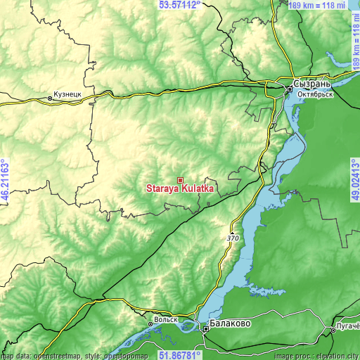
| \ | Map #1 | Map #2 | Topo.Map |
| Scale [m] | 100..217 m | 92..292 m | × |
| Scale [ft] | 328..712 ft | 302..958 ft | × |
| Average | 139.9 m = 459 ft | 165 m = 541 ft | × |
| Width | 5.92 km = 3.7 mi | 11.84 km = 7.4 mi | 189.4 km = 117.7 mi |
| Height | 5.92 km = 3.7 mi | 11.84 km = 7.4 mi | 189.4 km = 117.7 mi |
| ↑Max Latitude | 52.754385° | 52.780974° | 53.57112° |
| Latitude at center | 52.72778° | 52.72778° | 52.72778° |
| ↓Min Latitude | 52.701158° | 52.674521° | 51.86781° |
| ← Min Longitude | 47.573935° | 47.529989° | 46.21163° |
| Longitude center | 47.61788° | 47.61788° | 47.61788° |
| →Max Longitude | 47.661825° | 47.705771° | 49.02413° |
Nearby cities:
Cities around Staraya Kulatka sort by population:
• Khvalynsk elevation 39 m
42.2 km,  128°
128°
• Novospasskoye 71 m
47.4 km,  10°
10°
• Nikolayevka 131 m
52.2 km,  327°
327°
• Pavlovka 176 m
32.4 km,  262°
262°
• Dukhovnitskoye 35 m
48.6 km,  124°
124°
• Neverkino 228 m
59.3 km,  276°
276°
• Radishchevo 106 m
22.4 km,  50°
50°
• Cherkasskoye 89 m
43.1 km,  219°
219°
• Balasheyka 169 m
69.3 km,  26°
26°
• Alekseyevka 34 m
54.4 km,  149°
149°
• Kanadey 97 m
49.3 km,  352°
352°
• Tersa 27 m
71.5 km,  184°
184°
Multilingual:
 En español:
Staraya Kulatka elevación 109 m.
 En France:
Staraya Kulatka élévation 109 m.
 Auf Deutsch:
Staraya Kulatka höhe über dem Meeresspiegel ist 109 m.

Sources and notes:
- [note 1] Map square and city borders are not equal. Map elevation data is calculated only from area inside that square.
- [src 1] Elevation data from geonames database provided with same terms of usage.
- [src 2] The elevation map of Staraya Kulatka is generated using elevation data from NASA's 3 arcsec (90m) resolution SRTM data.
- [src 3] Base (background) map © OpenStreetMap contributors tiles are generated by Geofabrik and OpenTopoMap.
Copyright & License:
This Staraya Kulatka Elevation Map is licensed under CC BY-SA. You may reuse any part from this page, if you give a proper credit by linking to this URL:
 More info on terms of use page.