Kondol’ elevation
Kondol’ (Penza), Russia elevation is 200 meters and Kondol’ elevation in feet is 656 ft above sea level [src 1]. Kondol’ is a populated place (feature code) with elevation that is 1 meters (3 ft) bigger than average city elevation in Russia.
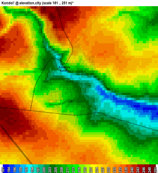
Below is the Elevation map of Kondol’, which displays elevation range with different colors. Scale of the first map is from 181 to 251 m (594 to 823 ft) with average elevation of 221.1 meters (=725 ft) [note 1]
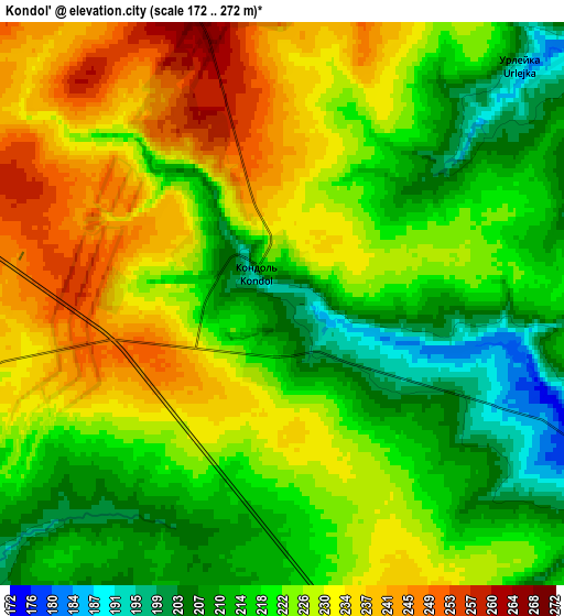
These maps also provides idea of topography and contour of this city, they are displayed at different zoom levels. More info about maps, scale and edge coordinates you can find below images.
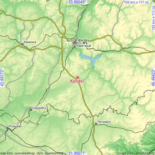
| \ | Map #1 | Map #2 | Topo.Map |
| Scale [m] | 181..251 m | 172..272 m | × |
| Scale [ft] | 594..823 ft | 564..892 ft | × |
| Average | 221.1 m = 725 ft | 223.1 m = 732 ft | × |
| Width | 5.91 km = 3.7 mi | 11.81 km = 7.3 mi | 189 km = 117.4 mi |
| Height | 5.91 km = 3.7 mi | 11.81 km = 7.3 mi | 189 km = 117.4 mi |
| ↑Max Latitude | 52.84544° | 52.871973° | 53.66045° |
| Latitude at center | 52.81889° | 52.81889° | 52.81889° |
| ↓Min Latitude | 52.792324° | 52.765742° | 51.96071° |
| ← Min Longitude | 45.014035° | 44.970089° | 43.65173° |
| Longitude center | 45.05798° | 45.05798° | 45.05798° |
| →Max Longitude | 45.101925° | 45.145871° | 46.46423° |
Nearby cities:
Cities around Kondol’ sort by population:
• Penza elevation 150 m
42.6 km,  355°
355°
• Zarechnyy 194 m
43.7 km,  11°
11°
• Bessonovka 136 m
54.6 km, 358°
• Kolyshley 208 m
37.5 km,  249°
249°
• Sursk 217 m
50.8 km,  55°
55°
• Shemysheyka 169 m
23.9 km,  70°
70°
• Chemodanovka 178 m
47.6 km,  15°
15°
• Malaya Serdoba 183 m
39.9 km,  190°
190°
• Zasechnoye 150 m
32.3 km,  2°
2°
• Bogoslovka 207 m
46.6 km,  338°
338°
• Kanayevka 173 m
46.6 km,  46°
46°
• Verkhozim 235 m
27 km,  116°
116°
Multilingual:
 En español:
Kondol’ elevación 200 m.
 En France:
Kondol’ élévation 200 m.


Sources and notes:
- [note 1] Map square and city borders are not equal. Map elevation data is calculated only from area inside that square.
- [src 1] Elevation data from geonames database provided with same terms of usage.
- [src 2] The elevation map of Kondol’ is generated using elevation data from NASA's 3 arcsec (90m) resolution SRTM data.
- [src 3] Base (background) map © OpenStreetMap contributors tiles are generated by Geofabrik and OpenTopoMap.
Copyright & License:
This Kondol’ Elevation Map is licensed under CC BY-SA. You may reuse any part from this page, if you give a proper credit by linking to this URL:
 More info on terms of use page.