Korsakovo elevation
Korsakovo (Orel Oblast), Russia elevation is 217 meters and Korsakovo elevation in feet is 712 ft above sea level [src 1]. Korsakovo is a populated place (feature code) with elevation that is 18 meters (59 ft) bigger than average city elevation in Russia.
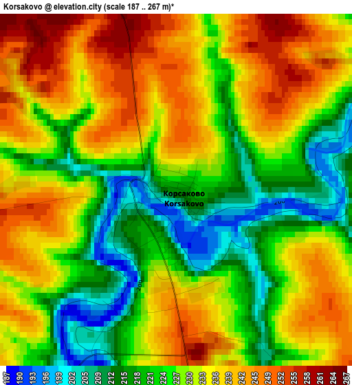
Below is the Elevation map of Korsakovo, which displays elevation range with different colors. Scale of the first map is from 187 to 267 m (614 to 876 ft) with average elevation of 230.1 meters (=755 ft) [note 1]
These maps also provides idea of topography and contour of this city, they are displayed at different zoom levels. More info about maps, scale and edge coordinates you can find below images.
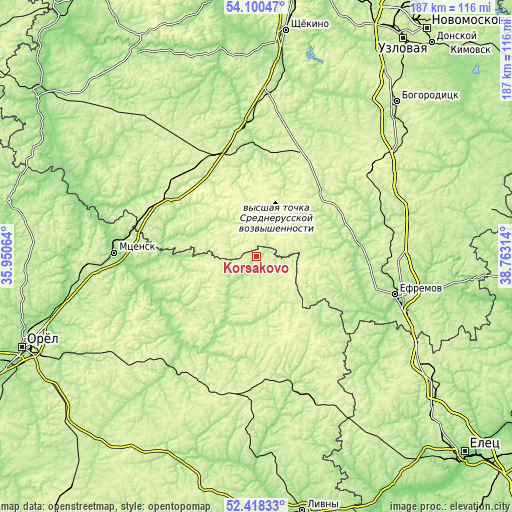
| \ | Map #1 | Topo.Map |
| Scale [m] | 187..267 m | × |
| Scale [ft] | 614..876 ft | × |
| Average | 230.1 m = 755 ft | × |
| Width | 5.84 km = 3.6 mi | 187 km = 116.2 mi |
| Height | 5.84 km = 3.6 mi | 187 km = 116.2 mi |
| ↑Max Latitude | 53.293945° | 54.10047° |
| Latitude at center | 53.26767° | 53.26767° |
| ↓Min Latitude | 53.241379° | 52.41833° |
| ← Min Longitude | 37.312945° | 35.95064° |
| Longitude center | 37.35689° | 37.35689° |
| →Max Longitude | 37.400835° | 38.76314° |
Nearby cities:
Cities around Korsakovo sort by population:
• Mtsensk elevation 160 m
52.1 km,  271°
271°
• Yefremov 207 m
51.2 km,  105°
105°
• Plavsk 180 m
49.3 km,  355°
355°
• Verkhov’ye 263 m
51.3 km,  188°
188°
• Chern’ 240 m
35.8 km,  304°
304°
• Zalegoshch’ 210 m
51.5 km,  217°
217°
• Tëploye 239 m
42.1 km,  21°
21°
• Khomutovo 252 m
46.3 km,  173°
173°
• Novosil’ 231 m
38.9 km,  212°
212°
• Spasskoye-Lutovinovo 237 m
50.1 km,  283°
283°
• Bol’shoye Skuratovo 247 m
39.2 km, 299°
• Kazachka 203 m
48.5 km,  77°
77°
Multilingual:
 En español:
Korsakovo elevación 217 m.
 En France:
Korsakovo élévation 217 m.
 Auf Deutsch:
Korsakovo höhe über dem Meeresspiegel ist 217 m.

Sources and notes:
- [note 1] Map square and city borders are not equal. Map elevation data is calculated only from area inside that square.
- [src 1] Elevation data from geonames database provided with same terms of usage.
- [src 2] The elevation map of Korsakovo is generated using elevation data from NASA's 3 arcsec (90m) resolution SRTM data.
- [src 3] Base (background) map © OpenStreetMap contributors tiles are generated by Geofabrik and OpenTopoMap.
Copyright & License:
This Korsakovo Elevation Map is licensed under CC BY-SA. You may reuse any part from this page, if you give a proper credit by linking to this URL:
 More info on terms of use page.