Krasnyy Kut elevation
Krasnyy Kut (Saratovskaya Oblast), Russia elevation is 45 meters and Krasnyy Kut elevation in feet is 148 ft above sea level [src 1]. Krasnyy Kut is a populated place (feature code) with elevation that is 154 meters (505 ft) smaller than average city elevation in Russia.
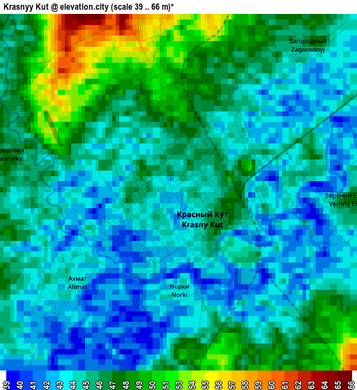
Below is the Elevation map of Krasnyy Kut, which displays elevation range with different colors. Scale of the first map is from 39 to 66 m (128 to 217 ft) with average elevation of 46.1 meters (=151 ft) [note 1]
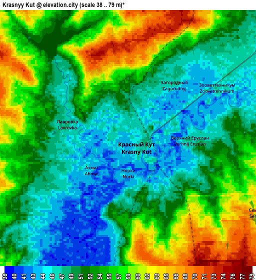
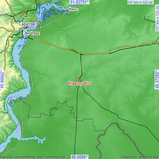
These maps also provides idea of topography and contour of this city, they are displayed at different zoom levels. More info about maps, scale and edge coordinates you can find below images.
| \ | Map #1 | Map #2 | Topo.Map |
| Scale [m] | 39..66 m | 38..79 m | × |
| Scale [ft] | 128..217 ft | 125..259 ft | × |
| Average | 46.1 m = 151 ft | 52.7 m = 173 ft | × |
| Width | 6.16 km = 3.8 mi | 12.31 km = 7.6 mi | 197 km = 122.4 mi |
| Height | 6.16 km = 3.8 mi | 12.31 km = 7.6 mi | 197 km = 122.4 mi |
| ↑Max Latitude | 50.977677° | 51.005338° | 51.82751° |
| Latitude at center | 50.95° | 50.95° | 50.95° |
| ↓Min Latitude | 50.922306° | 50.894596° | 50.0556° |
| ← Min Longitude | 46.922725° | 46.878779° | 45.56042° |
| Longitude center | 46.96667° | 46.96667° | 46.96667° |
| →Max Longitude | 47.010615° | 47.054561° | 48.37292° |
Nearby cities:
Cities around Krasnyy Kut sort by population:
• Engel’s elevation 12 m
84.4 km,  314°
314°
• Privolzhskiy 33 m
81.9 km, 308°
• Stepnoye 68 m
48.5 km,  350°
350°
• Mokrous 104 m
49.8 km,  50°
50°
• Piterka 43 m
45.1 km,  131°
131°
• Rovnoye 20 m
67.1 km,  253°
253°
• Staraya Poltavka 19 m
62.7 km,  213°
213°
• Sovetskoye 75 m
57 km,  344°
344°
• Krasnyy Yar 26 m
84.5 km,  333°
333°
• Pushkino 69 m
31.7 km,  0°
0°
• Shumeyka 18 m
84.6 km,  323°
323°
• Privolzhskoye 27 m
84.2 km, 348°
Multilingual:
 En español:
Krasnyy Kut elevación 45 m.
 En France:
Krasnyy Kut élévation 45 m.
 Auf Deutsch:
Krasnyy Kut höhe über dem Meeresspiegel ist 45 m.
 На русском:
Красн.Кут, Красный Кут высота над уровнем моря 45 м
Sources and notes:
- [note 1] Map square and city borders are not equal. Map elevation data is calculated only from area inside that square.
- [src 1] Elevation data from geonames database provided with same terms of usage.
- [src 2] The elevation map of Krasnyy Kut is generated using elevation data from NASA's 3 arcsec (90m) resolution SRTM data.
- [src 3] Base (background) map © OpenStreetMap contributors tiles are generated by Geofabrik and OpenTopoMap.
Copyright & License:
This Krasnyy Kut Elevation Map is licensed under CC BY-SA. You may reuse any part from this page, if you give a proper credit by linking to this URL:
 More info on terms of use page.