Privolzhskiy elevation
Privolzhskiy (Saratovskaya Oblast), Russia elevation is 33 meters and Privolzhskiy elevation in feet is 108 ft above sea level [src 1]. Privolzhskiy is a populated place (feature code) with elevation that is 166 meters (545 ft) smaller than average city elevation in Russia.
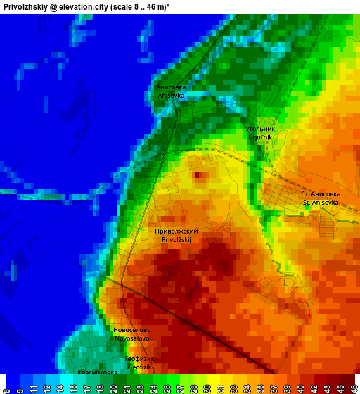
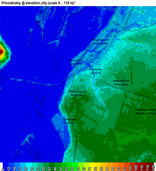
Below is the Elevation map of Privolzhskiy, which displays elevation range with different colors. Scale of the first map is from 8 to 46 m (26 to 151 ft) with average elevation of 23.4 meters (=77 ft) [note 1]
These maps also provides idea of topography and contour of this city, they are displayed at different zoom levels. More info about maps, scale and edge coordinates you can find below images.
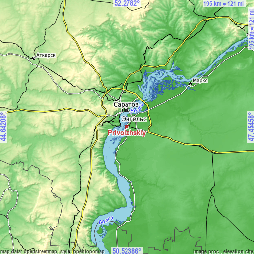
| \ | Map #1 | Map #2 | Topo.Map |
| Scale [m] | 8..46 m | 8..118 m | × |
| Scale [ft] | 26..151 ft | 26..387 ft | × |
| Average | 23.4 m = 77 ft | 23.1 m = 76 ft | × |
| Width | 6.1 km = 3.8 mi | 12.19 km = 7.6 mi | 195.1 km = 121.2 mi |
| Height | 6.1 km = 3.8 mi | 12.19 km = 7.6 mi | 195 km = 121.2 mi |
| ↑Max Latitude | 51.436843° | 51.464229° | 52.2782° |
| Latitude at center | 51.40944° | 51.40944° | 51.40944° |
| ↓Min Latitude | 51.382021° | 51.354585° | 50.52386° |
| ← Min Longitude | 46.004385° | 45.960439° | 44.64208° |
| Longitude center | 46.04833° | 46.04833° | 46.04833° |
| →Max Longitude | 46.092275° | 46.136221° | 47.45458° |
Nearby cities:
Cities around Privolzhskiy sort by population:
• Saratov elevation 72 m
14.8 km,  349°
349°
• Engel’s 12 m
9.2 km,  25°
25°
• Krasnoarmeysk 202 m
49.4 km,  209°
209°
• Stepnoye 68 m
55.7 km,  93°
93°
• Svetlyy 212 m
41.2 km,  315°
315°
• Tatishchevo 188 m
42.7 km,  312°
312°
• Sokolovyy 182 m
23.1 km, 319°
• Sovetskoye 75 m
48.3 km, 85°
• Krasnyy Oktyabr’ 280 m
27.9 km,  301°
301°
• Krasnyy Yar 26 m
35.6 km,  46°
46°
• Yelshanka 34 m
51.1 km, 28°
• Shumeyka 18 m
22 km,  38°
38°
Multilingual:
 En español:
Privolzhskiy elevación 33 m.
 En France:
Privolzhskiy élévation 33 m.
 Auf Deutsch:
Privolzhskiy höhe über dem Meeresspiegel ist 33 m.

Sources and notes:
- [note 1] Map square and city borders are not equal. Map elevation data is calculated only from area inside that square.
- [src 1] Elevation data from geonames database provided with same terms of usage.
- [src 2] The elevation map of Privolzhskiy is generated using elevation data from NASA's 3 arcsec (90m) resolution SRTM data.
- [src 3] Base (background) map © OpenStreetMap contributors tiles are generated by Geofabrik and OpenTopoMap.
Copyright & License:
This Privolzhskiy Elevation Map is licensed under CC BY-SA. You may reuse any part from this page, if you give a proper credit by linking to this URL:
 More info on terms of use page.