Kstovo elevation
Kstovo (Nizhny Novgorod Oblast, Kstovskiy Rayon), Russia elevation is 127 meters and Kstovo elevation in feet is 417 ft above sea level [src 1]. Kstovo is a populated place (feature code) with elevation that is 72 meters (236 ft) smaller than average city elevation in Russia.
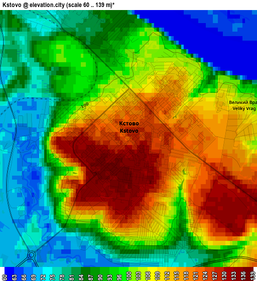
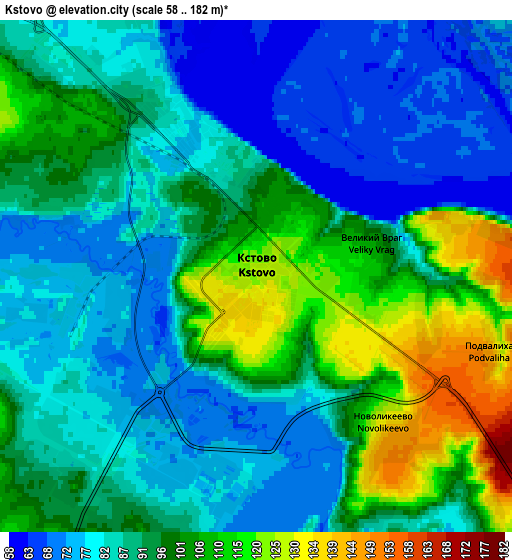
Below is the Elevation map of Kstovo, which displays elevation range with different colors. Scale of the first map is from 60 to 139 m (197 to 456 ft) with average elevation of 97.9 meters (=321 ft) [note 1]
These maps also provides idea of topography and contour of this city, they are displayed at different zoom levels. More info about maps, scale and edge coordinates you can find below images.
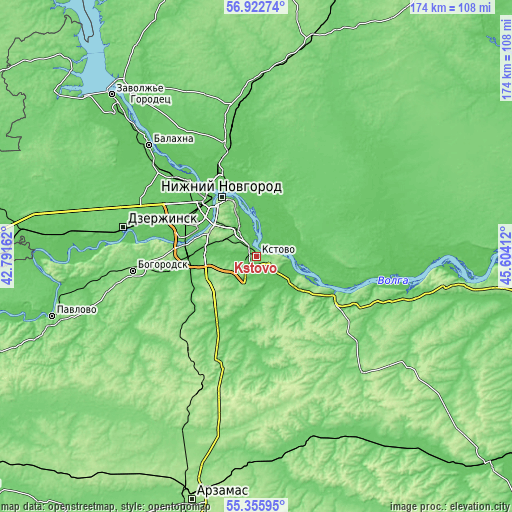
| \ | Map #1 | Map #2 | Topo.Map |
| Scale [m] | 60..139 m | 58..182 m | × |
| Scale [ft] | 197..456 ft | 190..597 ft | × |
| Average | 97.9 m = 321 ft | 91.1 m = 299 ft | × |
| Width | 5.44 km = 3.4 mi | 10.89 km = 6.8 mi | 174.2 km = 108.2 mi |
| Height | 5.44 km = 3.4 mi | 10.89 km = 6.8 mi | 174.2 km = 108.2 mi |
| ↑Max Latitude | 56.171802° | 56.196259° | 56.92274° |
| Latitude at center | 56.14733° | 56.14733° | 56.14733° |
| ↓Min Latitude | 56.122842° | 56.098339° | 55.35595° |
| ← Min Longitude | 44.153925° | 44.109979° | 42.79162° |
| Longitude center | 44.19787° | 44.19787° | 44.19787° |
| →Max Longitude | 44.241815° | 44.285761° | 45.60412° |
Nearby cities:
Cities around Kstovo sort by population:
• Nizhniy Novgorod elevation 141 m
23.5 km,  329°
329°
• Bor 79 m
24.6 km,  342°
342°
• Neklyudovo 76 m
32.7 km, 335°
• Pamyat’ Parizhskoy Kommuny 79 m
19 km,  104°
104°
• Gorbatovka 78 m
30.5 km,  293°
293°
• Afonino 132 m
14.2 km, 333°
• Burevestnik 95 m
25.4 km,  269°
269°
• Zelyony Gorod 118 m
8.4 km, 294°
• Pervoye Maya 100 m
32.4 km,  86°
86°
• Rabotki 119 m
27.7 km,  115°
115°
• Imeni M. I. Kalinina 69 m
9 km,  66°
66°
• Podnov’ye 106 m
18.8 km, 339°
Multilingual:
 En español:
Kstovo elevación 127 m.
 En France:
Kstovo élévation 127 m.


Sources and notes:
- [note 1] Map square and city borders are not equal. Map elevation data is calculated only from area inside that square.
- [src 1] Elevation data from geonames database provided with same terms of usage.
- [src 2] The elevation map of Kstovo is generated using elevation data from NASA's 3 arcsec (90m) resolution SRTM data.
- [src 3] Base (background) map © OpenStreetMap contributors tiles are generated by Geofabrik and OpenTopoMap.
Copyright & License:
This Kstovo Elevation Map is licensed under CC BY-SA. You may reuse any part from this page, if you give a proper credit by linking to this URL:
 More info on terms of use page.