Lukino elevation
Lukino (Nizhny Novgorod Oblast), Russia elevation is 76 meters and Lukino elevation in feet is 249 ft above sea level [src 1]. Lukino is a populated place (feature code) with elevation that is 123 meters (404 ft) smaller than average city elevation in Russia.
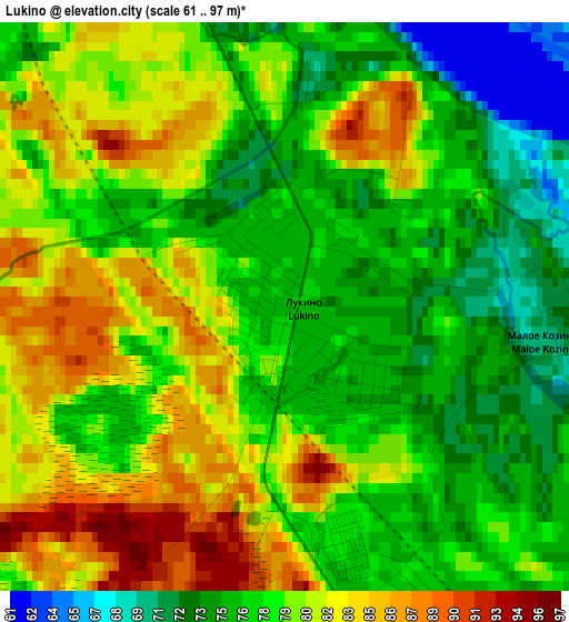
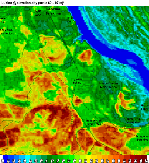
Below is the Elevation map of Lukino, which displays elevation range with different colors. Scale of the first map is from 61 to 97 m (200 to 318 ft) with average elevation of 78.7 meters (=258 ft) [note 1]
These maps also provides idea of topography and contour of this city, they are displayed at different zoom levels. More info about maps, scale and edge coordinates you can find below images.
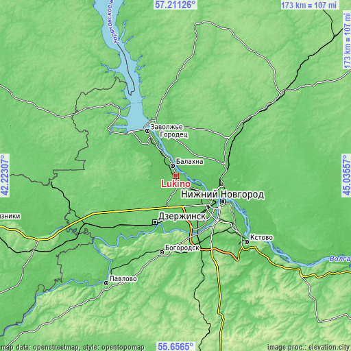
| \ | Map #1 | Map #2 | Topo.Map |
| Scale [m] | 61..97 m | 60..97 m | × |
| Scale [ft] | 200..318 ft | 197..318 ft | × |
| Average | 78.7 m = 258 ft | 77.5 m = 254 ft | × |
| Width | 5.4 km = 3.4 mi | 10.8 km = 6.7 mi | 172.9 km = 107.4 mi |
| Height | 5.4 km = 3.4 mi | 10.8 km = 6.7 mi | 172.9 km = 107.4 mi |
| ↑Max Latitude | 56.466114° | 56.490383° | 57.21126° |
| Latitude at center | 56.44183° | 56.44183° | 56.44183° |
| ↓Min Latitude | 56.41753° | 56.393214° | 55.6565° |
| ← Min Longitude | 43.585375° | 43.541429° | 42.22307° |
| Longitude center | 43.62932° | 43.62932° | 43.62932° |
| →Max Longitude | 43.673265° | 43.717211° | 45.03557° |
Nearby cities:
Cities around Lukino sort by population:
• Nizhniy Novgorod elevation 141 m
26.2 km,  118°
118°
• Dzerzhinsk 92 m
24.7 km,  205°
205°
• Novaya Balakhna 72 m
5.6 km,  342°
342°
• Gorodets 104 m
25.6 km, 337°
• Neklyudovo 76 m
21.6 km,  98°
98°
• Gidrotorf 76 m
6.7 km,  303°
303°
• Bol’shoye Kozino 75 m
6.7 km,  128°
128°
• Gorbatovka 78 m
21.8 km,  160°
160°
• Babino 75 m
24 km,  180°
180°
• Pervoye Maya 78 m
3.2 km,  153°
153°
• Pyra 99 m
23.6 km,  226°
226°
• Pervomayskiy 78 m
25.4 km,  319°
319°
Multilingual:
 En español:
Lukino elevación 76 m.
 En France:
Lukino élévation 76 m.


Sources and notes:
- [note 1] Map square and city borders are not equal. Map elevation data is calculated only from area inside that square.
- [src 1] Elevation data from geonames database provided with same terms of usage.
- [src 2] The elevation map of Lukino is generated using elevation data from NASA's 3 arcsec (90m) resolution SRTM data.
- [src 3] Base (background) map © OpenStreetMap contributors tiles are generated by Geofabrik and OpenTopoMap.
Copyright & License:
This Lukino Elevation Map is licensed under CC BY-SA. You may reuse any part from this page, if you give a proper credit by linking to this URL:
 More info on terms of use page.