Mglin elevation
Mglin (Bryansk Oblast), Russia elevation is 191 meters and Mglin elevation in feet is 627 ft above sea level [src 1]. Mglin is a populated place (feature code) with elevation that is 8 meters (26 ft) smaller than average city elevation in Russia.
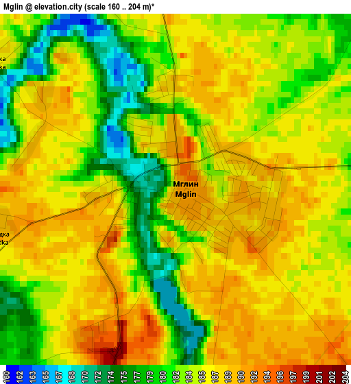
Below is the Elevation map of Mglin, which displays elevation range with different colors. Scale of the first map is from 160 to 204 m (525 to 669 ft) with average elevation of 184.7 meters (=606 ft) [note 1]
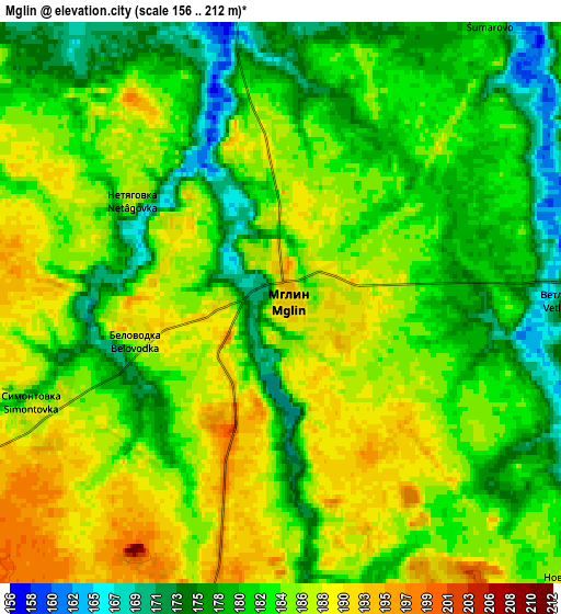
These maps also provides idea of topography and contour of this city, they are displayed at different zoom levels. More info about maps, scale and edge coordinates you can find below images.
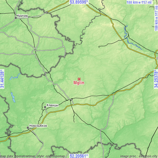
| \ | Map #1 | Map #2 | Topo.Map |
| Scale [m] | 160..204 m | 156..212 m | × |
| Scale [ft] | 525..669 ft | 512..696 ft | × |
| Average | 184.7 m = 606 ft | 183.1 m = 601 ft | × |
| Width | 5.87 km = 3.6 mi | 11.75 km = 7.3 mi | 187.9 km = 116.8 mi |
| Height | 5.87 km = 3.6 mi | 11.75 km = 7.3 mi | 187.9 km = 116.8 mi |
| ↑Max Latitude | 53.085473° | 53.111859° | 53.89595° |
| Latitude at center | 53.05907° | 53.05907° | 53.05907° |
| ↓Min Latitude | 53.032651° | 53.006216° | 52.20561° |
| ← Min Longitude | 32.803585° | 32.759639° | 31.44128° |
| Longitude center | 32.84753° | 32.84753° | 32.84753° |
| →Max Longitude | 32.891475° | 32.935421° | 34.25378° |
Nearby cities:
Cities around Mglin sort by population:
• Klintsy elevation 168 m
52.6 km,  230°
230°
• Unecha 189 m
26.4 km,  206°
206°
• Starodub 179 m
53.1 km,  186°
186°
• Pochep 163 m
42.4 km,  109°
109°
• Kletnya 184 m
44.2 km,  33°
33°
• Surazh 162 m
30.8 km,  261°
261°
• Pogar 155 m
62.6 km,  153°
153°
• Zaymishche 173 m
55.4 km, 228°
• Gordeyevka 143 m
59.8 km, 259°
• Ardon’ 168 m
51 km, 225°
• Zhiryatino 180 m
61.6 km,  72°
72°
• Korzhovka-Golubovka 171 m
46.3 km, 225°
Multilingual:
 En español:
Mglin elevación 191 m.
 En France:
Mgline élévation 191 m.


Sources and notes:
- [note 1] Map square and city borders are not equal. Map elevation data is calculated only from area inside that square.
- [src 1] Elevation data from geonames database provided with same terms of usage.
- [src 2] The elevation map of Mglin is generated using elevation data from NASA's 3 arcsec (90m) resolution SRTM data.
- [src 3] Base (background) map © OpenStreetMap contributors tiles are generated by Geofabrik and OpenTopoMap.
Copyright & License:
This Mglin Elevation Map is licensed under CC BY-SA. You may reuse any part from this page, if you give a proper credit by linking to this URL:
 More info on terms of use page.