Mikhaylovka elevation
Mikhaylovka (Kursk), Russia elevation is 185 meters and Mikhaylovka elevation in feet is 607 ft above sea level [src 1]. Mikhaylovka is a populated place (feature code) with elevation that is 14 meters (46 ft) smaller than average city elevation in Russia.
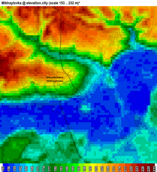
Below is the Elevation map of Mikhaylovka, which displays elevation range with different colors. Scale of the first map is from 153 to 232 m (502 to 761 ft) with average elevation of 181.1 meters (=594 ft) [note 1]
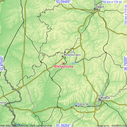
These maps also provides idea of topography and contour of this city, they are displayed at different zoom levels. More info about maps, scale and edge coordinates you can find below images.
| \ | Map #1 | Topo.Map |
| Scale [m] | 153..232 m | × |
| Scale [ft] | 502..761 ft | × |
| Average | 181.1 m = 594 ft | × |
| Width | 5.99 km = 3.7 mi | 191.5 km = 119 mi |
| Height | 5.99 km = 3.7 mi | 191.5 km = 119 mi |
| ↑Max Latitude | 52.258607° | 53.08465° |
| Latitude at center | 52.2317° | 52.2317° |
| ↓Min Latitude | 52.204777° | 51.36204° |
| ← Min Longitude | 35.332755° | 33.97045° |
| Longitude center | 35.3767° | 35.3767° |
| →Max Longitude | 35.420645° | 36.78295° |
Nearby cities:
Cities around Mikhaylovka sort by population:
• Zheleznogorsk elevation 199 m
11 km,  358°
358°
• Kromy 168 m
57.2 km,  27°
27°
• Komarichi 218 m
44.8 km,  297°
297°
• Dmitrovsk-Orlovskiy 208 m
34.2 km,  332°
332°
• Fatezh 200 m
36.8 km,  115°
115°
• Kokino 182 m
50 km,  306°
306°
• Ponyri Vtoryye 206 m
58 km,  84°
84°
• Konyshevka 225 m
43.7 km,  187°
187°
• Trosna 225 m
36.2 km,  49°
49°
• Soskovo 227 m
57.4 km,  0°
0°
• Lopandino 192 m
46.2 km, 304°
• Pervoavgustovskiy 210 m
21.9 km,  268°
268°
Multilingual:
 En español:
Mikhaylovka elevación 185 m.
 En France:
Mikhaylovka élévation 185 m.
 Auf Deutsch:
Mikhaylovka höhe über dem Meeresspiegel ist 185 m.

Sources and notes:
- [note 1] Map square and city borders are not equal. Map elevation data is calculated only from area inside that square.
- [src 1] Elevation data from geonames database provided with same terms of usage.
- [src 2] The elevation map of Mikhaylovka is generated using elevation data from NASA's 3 arcsec (90m) resolution SRTM data.
- [src 3] Base (background) map © OpenStreetMap contributors tiles are generated by Geofabrik and OpenTopoMap.
Copyright & License:
This Mikhaylovka Elevation Map is licensed under CC BY-SA. You may reuse any part from this page, if you give a proper credit by linking to this URL:
 More info on terms of use page.