Mulino elevation
Mulino (Nizhny Novgorod Oblast, Volodarskiy Rayon), Russia elevation is 98 meters and Mulino elevation in feet is 322 ft above sea level [src 1]. Mulino is a populated place (feature code) with elevation that is 101 meters (331 ft) smaller than average city elevation in Russia.
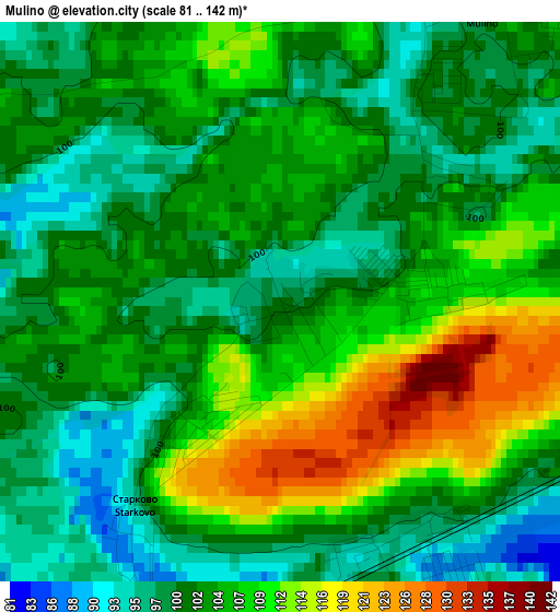
Below is the Elevation map of Mulino, which displays elevation range with different colors. Scale of the first map is from 81 to 142 m (266 to 466 ft) with average elevation of 104.1 meters (=342 ft) [note 1]
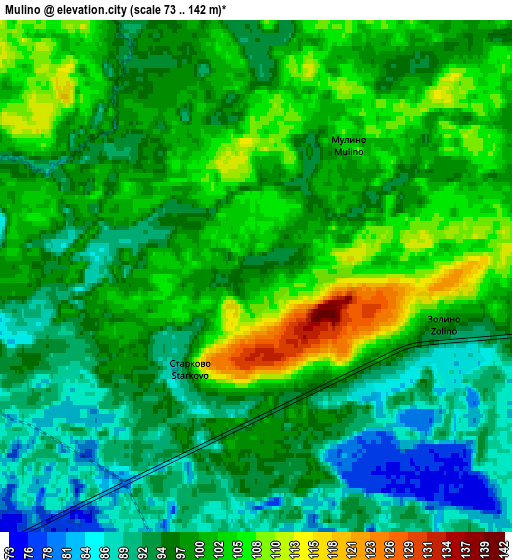
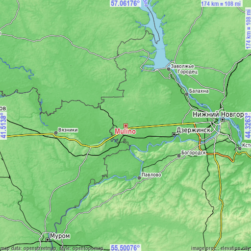
These maps also provides idea of topography and contour of this city, they are displayed at different zoom levels. More info about maps, scale and edge coordinates you can find below images.
| \ | Map #1 | Map #2 | Topo.Map |
| Scale [m] | 81..142 m | 73..142 m | × |
| Scale [ft] | 266..466 ft | 240..466 ft | × |
| Average | 104.1 m = 342 ft | 97.6 m = 320 ft | × |
| Width | 5.42 km = 3.4 mi | 10.85 km = 6.7 mi | 173.6 km = 107.9 mi |
| Height | 5.42 km = 3.4 mi | 10.85 km = 6.7 mi | 173.5 km = 107.8 mi |
| ↑Max Latitude | 56.313612° | 56.337978° | 57.06176° |
| Latitude at center | 56.28923° | 56.28923° | 56.28923° |
| ↓Min Latitude | 56.264833° | 56.24042° | 55.50076° |
| ← Min Longitude | 42.876105° | 42.832159° | 41.5138° |
| Longitude center | 42.92005° | 42.92005° | 42.92005° |
| →Max Longitude | 42.963995° | 43.007941° | 44.3263° |
Nearby cities:
Cities around Mulino sort by population:
• Gorokhovets elevation 81 m
17.1 km,  235°
235°
• Volodarsk 79 m
17.7 km,  111°
111°
• Ilyinogorsk 83 m
7.1 km,  163°
163°
• Reshetikha 99 m
24.2 km, 109°
• Novosmolinskiy 119 m
8.1 km,  94°
94°
• Yuganets 87 m
19.6 km,  102°
102°
• Tsentral’nyy 90 m
8.2 km,  276°
276°
• Smolino 89 m
10.7 km, 98°
• Pyra 99 m
26.7 km, 88°
• Gorbatov 172 m
19.7 km,  153°
153°
• Frolishchi 107 m
22.1 km,  311°
311°
• Galitsy 78 m
13.2 km,  200°
200°
Multilingual:
 En español:
Mulino elevación 98 m.
 En France:
Mulino élévation 98 m.


Sources and notes:
- [note 1] Map square and city borders are not equal. Map elevation data is calculated only from area inside that square.
- [src 1] Elevation data from geonames database provided with same terms of usage.
- [src 2] The elevation map of Mulino is generated using elevation data from NASA's 3 arcsec (90m) resolution SRTM data.
- [src 3] Base (background) map © OpenStreetMap contributors tiles are generated by Geofabrik and OpenTopoMap.
Copyright & License:
This Mulino Elevation Map is licensed under CC BY-SA. You may reuse any part from this page, if you give a proper credit by linking to this URL:
 More info on terms of use page.