Reshetikha elevation
Reshetikha (Nizhny Novgorod Oblast), Russia elevation is 99 meters and Reshetikha elevation in feet is 325 ft above sea level [src 1]. Reshetikha is a populated place (feature code) with elevation that is 100 meters (328 ft) smaller than average city elevation in Russia.
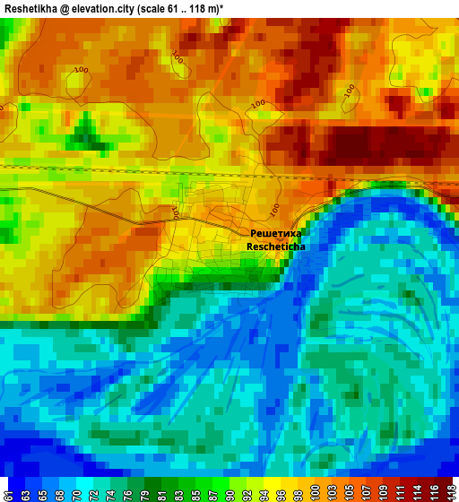
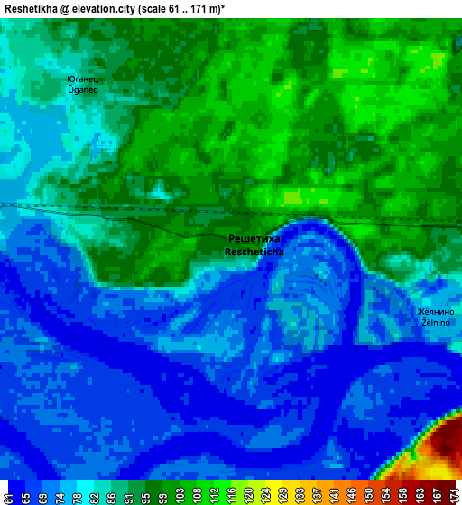
Below is the Elevation map of Reshetikha, which displays elevation range with different colors. Scale of the first map is from 61 to 118 m (200 to 387 ft) with average elevation of 86.8 meters (=285 ft) [note 1]
These maps also provides idea of topography and contour of this city, they are displayed at different zoom levels. More info about maps, scale and edge coordinates you can find below images.
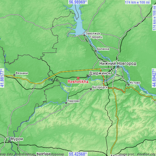
| \ | Map #1 | Map #2 | Topo.Map |
| Scale [m] | 61..118 m | 61..171 m | × |
| Scale [ft] | 200..387 ft | 200..561 ft | × |
| Average | 86.8 m = 285 ft | 84.9 m = 279 ft | × |
| Width | 5.43 km = 3.4 mi | 10.87 km = 6.8 mi | 173.9 km = 108.1 mi |
| Height | 5.43 km = 3.4 mi | 10.87 km = 6.8 mi | 173.9 km = 108.1 mi |
| ↑Max Latitude | 56.240089° | 56.264502° | 56.98969° |
| Latitude at center | 56.21566° | 56.21566° | 56.21566° |
| ↓Min Latitude | 56.191216° | 56.166756° | 55.42568° |
| ← Min Longitude | 43.244075° | 43.200129° | 41.88177° |
| Longitude center | 43.28802° | 43.28802° | 43.28802° |
| →Max Longitude | 43.331965° | 43.375911° | 44.69427° |
Nearby cities:
Cities around Reshetikha sort by population:
• Dzerzhinsk elevation 92 m
10.7 km,  74°
74°
• Bogorodsk 131 m
18.6 km,  131°
131°
• Vorsma 89 m
25 km,  182°
182°
• Mulino 98 m
24.2 km,  289°
289°
• Volodarsk 79 m
6.4 km, 285°
• Ilyinogorsk 83 m
20.7 km,  273°
273°
• Novosmolinskiy 119 m
16.5 km,  297°
297°
• Yuganets 87 m
5.3 km,  317°
317°
• Smolino 89 m
13.9 km, 298°
• Babino 75 m
20.8 km,  86°
86°
• Pyra 99 m
9.7 km,  24°
24°
• Gorbatov 172 m
16.8 km,  235°
235°
Multilingual:
 En español:
Reshetikha elevación 99 m.
 En France:
Reshetikha élévation 99 m.
 Auf Deutsch:
Reshetikha höhe über dem Meeresspiegel ist 99 m.

Sources and notes:
- [note 1] Map square and city borders are not equal. Map elevation data is calculated only from area inside that square.
- [src 1] Elevation data from geonames database provided with same terms of usage.
- [src 2] The elevation map of Reshetikha is generated using elevation data from NASA's 3 arcsec (90m) resolution SRTM data.
- [src 3] Base (background) map © OpenStreetMap contributors tiles are generated by Geofabrik and OpenTopoMap.
Copyright & License:
This Reshetikha Elevation Map is licensed under CC BY-SA. You may reuse any part from this page, if you give a proper credit by linking to this URL:
 More info on terms of use page.