Nikulino elevation
Nikulino (Moscow), Russia elevation is 180 meters and Nikulino elevation in feet is 591 ft above sea level [src 1]. Nikulino is a historical populated place (feature code) with elevation that is 19 meters (62 ft) smaller than average city elevation in Russia.
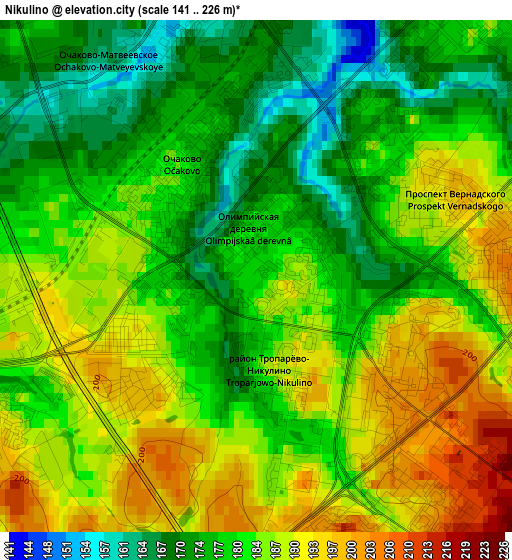
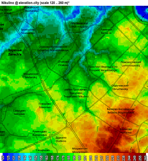
Below is the Elevation map of Nikulino, which displays elevation range with different colors. Scale of the first map is from 141 to 226 m (463 to 741 ft) with average elevation of 182.4 meters (=598 ft) [note 1]
These maps also provides idea of topography and contour of this city, they are displayed at different zoom levels. More info about maps, scale and edge coordinates you can find below images.
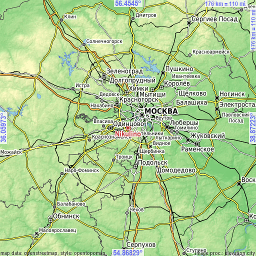
| \ | Map #1 | Map #2 | Topo.Map |
| Scale [m] | 141..226 m | 120..260 m | × |
| Scale [ft] | 463..741 ft | 394..853 ft | × |
| Average | 182.4 m = 598 ft | 186 m = 610 ft | × |
| Width | 5.51 km = 3.4 mi | 11.02 km = 6.8 mi | 176.4 km = 109.6 mi |
| Height | 5.51 km = 3.4 mi | 11.02 km = 6.8 mi | 176.4 km = 109.6 mi |
| ↑Max Latitude | 55.694206° | 55.718966° | 56.4545° |
| Latitude at center | 55.66943° | 55.66943° | 55.66943° |
| ↓Min Latitude | 55.644638° | 55.619831° | 54.86829° |
| ← Min Longitude | 37.422035° | 37.378089° | 36.05973° |
| Longitude center | 37.46598° | 37.46598° | 37.46598° |
| →Max Longitude | 37.509925° | 37.553871° | 38.87223° |
Nearby cities:
Cities around Nikulino sort by population:
• Ramenki elevation 179 m
4 km,  32°
32°
• Troparëvo 197 m
1.9 km,  140°
140°
• Ochakovo-Matveyevskoye 171 m
2.1 km,  323°
323°
• Semënovskoye 175 m
5.5 km,  73°
73°
• Nikol’skoye 171 m
1.9 km,  35°
35°
• Davydkovo 136 m
5.4 km,  4°
4°
• Matveyevskoye 164 m
4.7 km,  6°
6°
• Amin’yevo 164 m
3.4 km, 0°
• Mikhalkovo 167 m
2.6 km,  307°
307°
• Vostryakovo 182 m
1 km,  252°
252°
• Zarech’ye 168 m
5 km,  292°
292°
• Mosrentgen 211 m
5.5 km,  181°
181°
Multilingual:
 En español:
Nikulino elevación 180 m.
 En France:
Nikulino élévation 180 m.
 Auf Deutsch:
Nikulino höhe über dem Meeresspiegel ist 180 m.

Sources and notes:
- [note 1] Map square and city borders are not equal. Map elevation data is calculated only from area inside that square.
- [src 1] Elevation data from geonames database provided with same terms of usage.
- [src 2] The elevation map of Nikulino is generated using elevation data from NASA's 3 arcsec (90m) resolution SRTM data.
- [src 3] Base (background) map © OpenStreetMap contributors tiles are generated by Geofabrik and OpenTopoMap.
Copyright & License:
This Nikulino Elevation Map is licensed under CC BY-SA. You may reuse any part from this page, if you give a proper credit by linking to this URL:
 More info on terms of use page.