Ramenki elevation
Ramenki (Moscow), Russia elevation is 179 meters and Ramenki elevation in feet is 587 ft above sea level [src 1]. Ramenki is a section of populated place (feature code) with elevation that is 20 meters (66 ft) smaller than average city elevation in Russia.
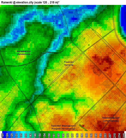
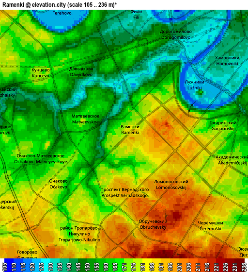
Below is the Elevation map of Ramenki, which displays elevation range with different colors. Scale of the first map is from 120 to 218 m (394 to 715 ft) with average elevation of 168.6 meters (=553 ft) [note 1]
These maps also provides idea of topography and contour of this city, they are displayed at different zoom levels. More info about maps, scale and edge coordinates you can find below images.
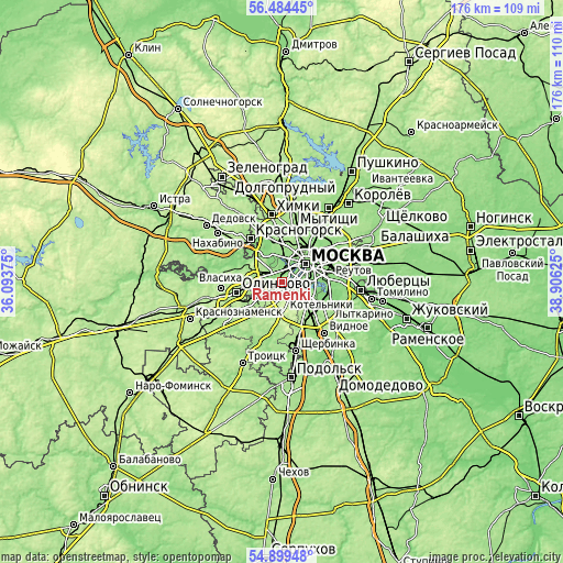
| \ | Map #1 | Map #2 | Topo.Map |
| Scale [m] | 120..218 m | 105..236 m | × |
| Scale [ft] | 394..715 ft | 344..774 ft | × |
| Average | 168.6 m = 553 ft | 168 m = 551 ft | × |
| Width | 5.51 km = 3.4 mi | 11.01 km = 6.8 mi | 176.2 km = 109.5 mi |
| Height | 5.51 km = 3.4 mi | 11.01 km = 6.8 mi | 176.2 km = 109.5 mi |
| ↑Max Latitude | 55.724756° | 55.749497° | 56.48445° |
| Latitude at center | 55.7° | 55.7° | 55.7° |
| ↓Min Latitude | 55.675228° | 55.65044° | 54.89948° |
| ← Min Longitude | 37.456055° | 37.412109° | 36.09375° |
| Longitude center | 37.5° | 37.5° | 37.5° |
| →Max Longitude | 37.543945° | 37.587891° | 38.90625° |
Nearby cities:
Cities around Ramenki sort by population:
• Ochakovo-Matveyevskoye elevation 171 m
3.8 km,  242°
242°
• Semënovskoye 175 m
3.6 km,  120°
120°
• Nikol’skoye 171 m
2.1 km,  209°
209°
• Mikhalkovo 167 m
4.6 km,  246°
246°
• Leninskiye Gory 175 m
4.2 km,  90°
90°
• Nikulino 180 m
4 km, 212°
• Luzhniki 161 m
3.8 km,  62°
62°
• Vorob’yovo 177 m
2.8 km,  48°
48°
• Davydkovo 136 m
2.6 km,  319°
319°
• Amin’yevo 164 m
2.1 km,  270°
270°
• Matveyevskoye 164 m
2 km,  308°
308°
• Kastanayevo 134 m
1.9 km,  0°
0°
Multilingual:
 En español:
Ramenki elevación 179 m.
 En France:
Ramenki élévation 179 m.


Sources and notes:
- [note 1] Map square and city borders are not equal. Map elevation data is calculated only from area inside that square.
- [src 1] Elevation data from geonames database provided with same terms of usage.
- [src 2] The elevation map of Ramenki is generated using elevation data from NASA's 3 arcsec (90m) resolution SRTM data.
- [src 3] Base (background) map © OpenStreetMap contributors tiles are generated by Geofabrik and OpenTopoMap.
Copyright & License:
This Ramenki Elevation Map is licensed under CC BY-SA. You may reuse any part from this page, if you give a proper credit by linking to this URL:
 More info on terms of use page.