Nizhnyaya Tura elevation
Nizhnyaya Tura (Sverdlovsk), Russia elevation is 202 meters and Nizhnyaya Tura elevation in feet is 663 ft above sea level [src 1]. Nizhnyaya Tura is a populated place (feature code) with elevation that is 3 meters (10 ft) bigger than average city elevation in Russia.
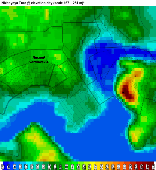
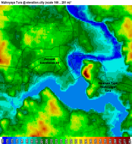
Below is the Elevation map of Nizhnyaya Tura, which displays elevation range with different colors. Scale of the first map is from 167 to 281 m (548 to 922 ft) with average elevation of 200.5 meters (=658 ft) [note 1]
These maps also provides idea of topography and contour of this city, they are displayed at different zoom levels. More info about maps, scale and edge coordinates you can find below images.
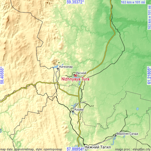
| \ | Map #1 | Map #2 | Topo.Map |
| Scale [m] | 167..281 m | 166..281 m | × |
| Scale [ft] | 548..922 ft | 545..922 ft | × |
| Average | 200.5 m = 658 ft | 205.2 m = 673 ft | × |
| Width | 5.09 km = 3.2 mi | 10.17 km = 6.3 mi | 162.8 km = 101.2 mi |
| Height | 5.09 km = 3.2 mi | 10.17 km = 6.3 mi | 162.8 km = 101.2 mi |
| ↑Max Latitude | 58.652169° | 58.675024° | 59.35372° |
| Latitude at center | 58.6293° | 58.6293° | 58.6293° |
| ↓Min Latitude | 58.606416° | 58.583517° | 57.88954° |
| ← Min Longitude | 59.767855° | 59.723909° | 58.40555° |
| Longitude center | 59.8118° | 59.8118° | 59.8118° |
| →Max Longitude | 59.855745° | 59.899691° | 61.21805° |
Nearby cities:
Cities around Nizhnyaya Tura sort by population:
• Kachkanar elevation 366 m
20.5 km,  292°
292°
• Kushva 301 m
37.8 km,  184°
184°
• Krasnoural’sk 221 m
32.4 km,  155°
155°
• Lesnoy 221 m
1 km,  325°
325°
• Baranchinskiy 221 m
52.4 km,  187°
187°
• Verkhnyaya Tura 212 m
29.9 km, 180°
• Verkhotur’ye 101 m
62.9 km,  65°
65°
• Is 193 m
18.8 km,  343°
343°
• Tëplaya Gora 382 m
44.4 km,  254°
254°
• Valerianovsk 218 m
20.6 km,  315°
315°
• Sarany 447 m
55.7 km,  255°
255°
• Yëlkino 164 m
7.1 km,  9°
9°
Multilingual:
 En español:
Nízhniaya Turá elevación 202 m.
 En France:
Nijniaïa Toura élévation 202 m.
 Auf Deutsch:
Nischnjaja Tura höhe über dem Meeresspiegel ist 202 m.

Sources and notes:
- [note 1] Map square and city borders are not equal. Map elevation data is calculated only from area inside that square.
- [src 1] Elevation data from geonames database provided with same terms of usage.
- [src 2] The elevation map of Nizhnyaya Tura is generated using elevation data from NASA's 3 arcsec (90m) resolution SRTM data.
- [src 3] Base (background) map © OpenStreetMap contributors tiles are generated by Geofabrik and OpenTopoMap.
Copyright & License:
This Nizhnyaya Tura Elevation Map is licensed under CC BY-SA. You may reuse any part from this page, if you give a proper credit by linking to this URL:
 More info on terms of use page.