Orël elevation
Orël (Orel Oblast), Russia elevation is 154 meters and Orël elevation in feet is 505 ft above sea level [src 1]. Orël is a seat of a first-order administrative division (feature code) with elevation that is 45 meters (148 ft) smaller than average city elevation in Russia.
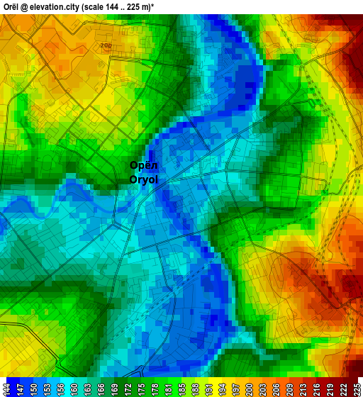
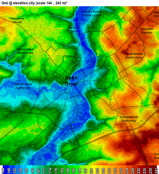
Below is the Elevation map of Orël, which displays elevation range with different colors. Scale of the first map is from 144 to 225 m (472 to 738 ft) with average elevation of 176.4 meters (=579 ft) [note 1]
These maps also provides idea of topography and contour of this city, they are displayed at different zoom levels. More info about maps, scale and edge coordinates you can find below images.
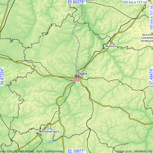
| \ | Map #1 | Map #2 | Topo.Map |
| Scale [m] | 144..225 m | 144..243 m | × |
| Scale [ft] | 472..738 ft | 472..797 ft | × |
| Average | 176.4 m = 579 ft | 189.6 m = 622 ft | × |
| Width | 5.89 km = 3.7 mi | 11.77 km = 7.3 mi | 188.4 km = 117.1 mi |
| Height | 5.89 km = 3.7 mi | 11.77 km = 7.3 mi | 188.3 km = 117 mi |
| ↑Max Latitude | 52.99154° | 53.017984° | 53.80379° |
| Latitude at center | 52.96508° | 52.96508° | 52.96508° |
| ↓Min Latitude | 52.938604° | 52.912111° | 52.10977° |
| ← Min Longitude | 36.034545° | 35.990599° | 34.67224° |
| Longitude center | 36.07849° | 36.07849° | 36.07849° |
| →Max Longitude | 36.122435° | 36.166381° | 37.48474° |
Nearby cities:
Cities around Orël sort by population:
• Mtsensk elevation 160 m
47.9 km,  43°
43°
• Znamenka 157 m
10.1 km,  222°
222°
• Bolkhov 189 m
53.4 km,  354°
354°
• Naryshkino 209 m
23.6 km,  270°
270°
• Kromy 168 m
37.3 km,  214°
214°
• Glazunovka 247 m
54.1 km,  162°
162°
• Zmiyëvka 221 m
38.6 km,  149°
149°
• Zalegoshch’ 210 m
54.9 km,  97°
97°
• Khotynets 217 m
49.1 km,  291°
291°
• Soskovo 227 m
52.6 km,  242°
242°
• Znamenskoye 197 m
43.4 km,  323°
323°
• Spasskoye-Lutovinovo 237 m
57.8 km, 38°
Multilingual:
 En español:
Orël elevación 154 m.
 En France:
Orel élévation 154 m.


Sources and notes:
- [note 1] Map square and city borders are not equal. Map elevation data is calculated only from area inside that square.
- [src 1] Elevation data from geonames database provided with same terms of usage.
- [src 2] The elevation map of Orël is generated using elevation data from NASA's 3 arcsec (90m) resolution SRTM data.
- [src 3] Base (background) map © OpenStreetMap contributors tiles are generated by Geofabrik and OpenTopoMap.
Copyright & License:
This Orël Elevation Map is licensed under CC BY-SA. You may reuse any part from this page, if you give a proper credit by linking to this URL:
 More info on terms of use page.