Zmiyëvka elevation
Zmiyëvka (Orel Oblast), Russia elevation is 221 meters and Zmiyëvka elevation in feet is 725 ft above sea level [src 1]. Zmiyëvka is a populated place (feature code) with elevation that is 22 meters (72 ft) bigger than average city elevation in Russia.
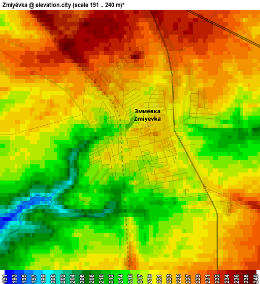
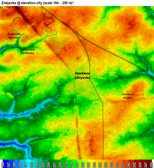
Below is the Elevation map of Zmiyëvka, which displays elevation range with different colors. Scale of the first map is from 191 to 240 m (627 to 787 ft) with average elevation of 220.8 meters (=724 ft) [note 1]
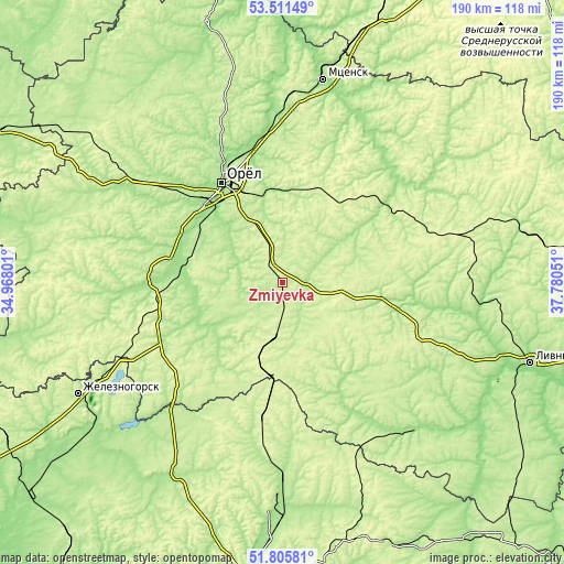
These maps also provides idea of topography and contour of this city, they are displayed at different zoom levels. More info about maps, scale and edge coordinates you can find below images.
| \ | Map #1 | Map #2 | Topo.Map |
| Scale [m] | 191..240 m | 184..250 m | × |
| Scale [ft] | 627..787 ft | 604..820 ft | × |
| Average | 220.8 m = 724 ft | 221.6 m = 727 ft | × |
| Width | 5.93 km = 3.7 mi | 11.85 km = 7.4 mi | 189.7 km = 117.9 mi |
| Height | 5.93 km = 3.7 mi | 11.85 km = 7.4 mi | 189.6 km = 117.8 mi |
| ↑Max Latitude | 52.693612° | 52.720238° | 53.51149° |
| Latitude at center | 52.66697° | 52.66697° | 52.66697° |
| ↓Min Latitude | 52.640311° | 52.613636° | 51.80581° |
| ← Min Longitude | 36.330315° | 36.286369° | 34.96801° |
| Longitude center | 36.37426° | 36.37426° | 36.37426° |
| →Max Longitude | 36.418205° | 36.462151° | 37.78051° |
Nearby cities:
Cities around Zmiyëvka sort by population:
• Orël elevation 154 m
38.6 km,  329°
329°
• Znamenka 157 m
37.1 km,  313°
313°
• Naryshkino 209 m
54.9 km, 307°
• Verkhov’ye 263 m
60.6 km,  74°
74°
• Kromy 168 m
41 km,  273°
273°
• Glazunovka 247 m
18.9 km,  191°
191°
• Zalegoshch’ 210 m
43.3 km,  53°
53°
• Ponyri Vtoryye 206 m
44.2 km, 193°
• Pokrovskoye 196 m
34.1 km,  100°
100°
• Novosil’ 231 m
56.3 km, 52°
• Maloarkhangel’sk 216 m
30.9 km,  163°
163°
• Trosna 225 m
47.2 km,  238°
238°
Multilingual:
 En español:
Zmiyëvka elevación 221 m.
 En France:
Zmiyëvka élévation 221 m.
 Auf Deutsch:
Zmiyëvka höhe über dem Meeresspiegel ist 221 m.

Sources and notes:
- [note 1] Map square and city borders are not equal. Map elevation data is calculated only from area inside that square.
- [src 1] Elevation data from geonames database provided with same terms of usage.
- [src 2] The elevation map of Zmiyëvka is generated using elevation data from NASA's 3 arcsec (90m) resolution SRTM data.
- [src 3] Base (background) map © OpenStreetMap contributors tiles are generated by Geofabrik and OpenTopoMap.
Copyright & License:
This Zmiyëvka Elevation Map is licensed under CC BY-SA. You may reuse any part from this page, if you give a proper credit by linking to this URL:
 More info on terms of use page.