Pechora elevation
Pechora (Komi), Russia elevation is 60 meters and Pechora elevation in feet is 197 ft above sea level [src 1]. Pechora is a populated place (feature code) with elevation that is 139 meters (456 ft) smaller than average city elevation in Russia.
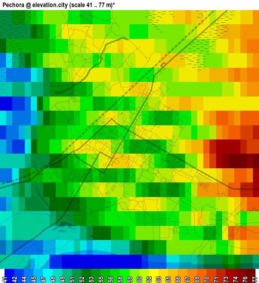
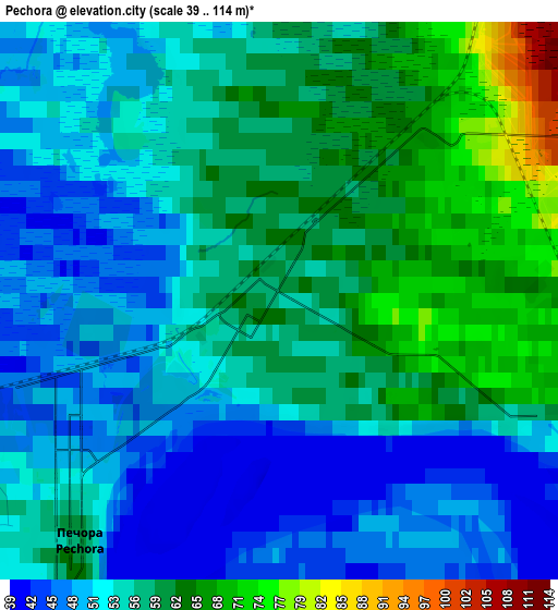
Below is the Elevation map of Pechora, which displays elevation range with different colors. Scale of the first map is from 41 to 77 m (135 to 253 ft) with average elevation of 57.7 meters (=189 ft) [note 1]
These maps also provides idea of topography and contour of this city, they are displayed at different zoom levels. More info about maps, scale and edge coordinates you can find below images.
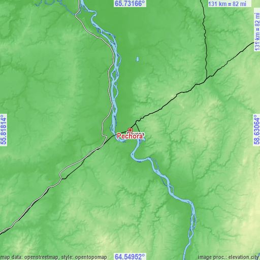
| \ | Map #1 | Map #2 | Topo.Map |
| Scale [m] | 41..77 m | 39..114 m | × |
| Scale [ft] | 135..253 ft | 128..374 ft | × |
| Average | 57.7 m = 189 ft | 55.8 m = 183 ft | × |
| Width | 4.11 km = 2.6 mi | 8.21 km = 5.1 mi | 131.4 km = 81.6 mi |
| Height | 4.11 km = 2.6 mi | 8.21 km = 5.1 mi | 131.4 km = 81.6 mi |
| ↑Max Latitude | 65.165633° | 65.184084° | 65.73166° |
| Latitude at center | 65.14717° | 65.14717° | 65.14717° |
| ↓Min Latitude | 65.128694° | 65.110205° | 64.54952° |
| ← Min Longitude | 57.180445° | 57.136499° | 55.81814° |
| Longitude center | 57.22439° | 57.22439° | 57.22439° |
| →Max Longitude | 57.268335° | 57.312281° | 58.63064° |
Nearby cities:
Cities around Pechora sort by population:
• Usinsk elevation 78 m
95.2 km,  8°
8°
• Sosnogorsk 82 m
235.2 km,  223°
223°
• Vuktyl 107 m
143.5 km,  178°
178°
• Nizhniy Odes 170 m
202.1 km,  214°
214°
• Izhma 45 m
156 km,  264°
264°
• Kozhva 67 m
9.5 km,  242°
242°
• Saranpaul’ 32 m
200.6 km,  119°
119°
• Verkhnyaya Inta 99 m
169.5 km,  56°
56°
• Inta 51 m
167.1 km,  53°
53°
• Parma 64 m
97.3 km, 12°
• Puteyets 40 m
6.8 km,  293°
293°
• Synya 97 m
45.4 km, 56°
Multilingual:
 En español:
Pechora elevación 60 m.
 En France:
Petchora élévation 60 m.
 Auf Deutsch:
Petschora höhe über dem Meeresspiegel ist 60 m.

Sources and notes:
- [note 1] Map square and city borders are not equal. Map elevation data is calculated only from area inside that square.
- [src 1] Elevation data from geonames database provided with same terms of usage.
- [src 2] The elevation map of Pechora is generated using GMTED2010 database with 7.5 arcsec (225m) resolution.
- [src 3] Base (background) map © OpenStreetMap contributors tiles are generated by Geofabrik and OpenTopoMap.
Copyright & License:
This Pechora Elevation Map is licensed under CC BY-SA. You may reuse any part from this page, if you give a proper credit by linking to this URL:
 More info on terms of use page.