Petropavlovskaya elevation
Petropavlovskaya (Chechnya), Russia elevation is 113 meters and Petropavlovskaya elevation in feet is 371 ft above sea level [src 1]. Petropavlovskaya is a populated place (feature code) with elevation that is 86 meters (282 ft) smaller than average city elevation in Russia.
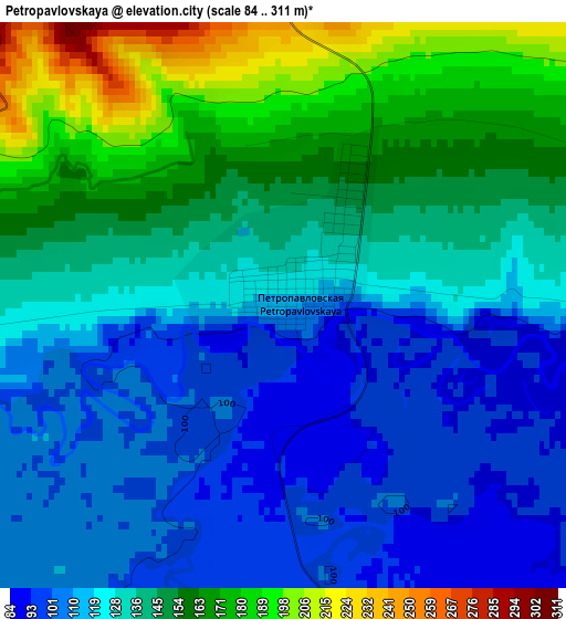
Below is the Elevation map of Petropavlovskaya, which displays elevation range with different colors. Scale of the first map is from 84 to 311 m (276 to 1020 ft) with average elevation of 135.2 meters (=444 ft) [note 1]
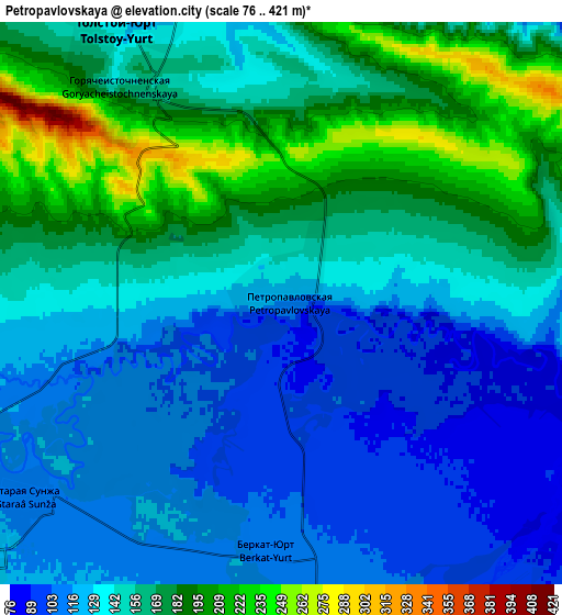
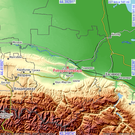
These maps also provides idea of topography and contour of this city, they are displayed at different zoom levels. More info about maps, scale and edge coordinates you can find below images.
| \ | Map #1 | Map #2 | Topo.Map |
| Scale [m] | 84..311 m | 76..421 m | × |
| Scale [ft] | 276..1020 ft | 249..1381 ft | × |
| Average | 135.2 m = 444 ft | 148.6 m = 488 ft | × |
| Width | 7.1 km = 4.4 mi | 14.21 km = 8.8 mi | 227.3 km = 141.2 mi |
| Height | 7.1 km = 4.4 mi | 14.21 km = 8.8 mi | 227.3 km = 141.2 mi |
| ↑Max Latitude | 43.411372° | 43.443287° | 44.39291° |
| Latitude at center | 43.37944° | 43.37944° | 43.37944° |
| ↓Min Latitude | 43.347491° | 43.315526° | 42.34874° |
| ← Min Longitude | 45.782165° | 45.738219° | 44.41986° |
| Longitude center | 45.82611° | 45.82611° | 45.82611° |
| →Max Longitude | 45.870055° | 45.914001° | 47.23236° |
Nearby cities:
Cities around Petropavlovskaya sort by population:
• Groznyy elevation 128 m
13.4 km,  235°
235°
• Argun 111 m
10 km,  156°
156°
• Tsotsin-Yurt 133 m
20.8 km,  137°
137°
• Mesker-Yurt 135 m
15.7 km, 155°
• Germenchuk 188 m
22.9 km, 160°
• Khankala 127 m
10.3 km,  213°
213°
• Staraya Sunzha 112 m
8.3 km,  233°
233°
• Tolstoy-Yurt 123 m
8.3 km,  332°
332°
• Chechen-Aul 201 m
20.2 km,  188°
188°
• Dzhalka 84 m
14.7 km,  117°
117°
• Prigorodnoye 165 m
15.1 km,  201°
201°
• Belgatoy 199 m
21.1 km,  178°
178°
Multilingual:
 En español:
Petropavlovskaya elevación 113 m.
 En France:
Petropavlovskaya élévation 113 m.
 Auf Deutsch:
Petropavlovskaya höhe über dem Meeresspiegel ist 113 m.

Sources and notes:
- [note 1] Map square and city borders are not equal. Map elevation data is calculated only from area inside that square.
- [src 1] Elevation data from geonames database provided with same terms of usage.
- [src 2] The elevation map of Petropavlovskaya is generated using elevation data from NASA's 3 arcsec (90m) resolution SRTM data.
- [src 3] Base (background) map © OpenStreetMap contributors tiles are generated by Geofabrik and OpenTopoMap.
Copyright & License:
This Petropavlovskaya Elevation Map is licensed under CC BY-SA. You may reuse any part from this page, if you give a proper credit by linking to this URL:
 More info on terms of use page.