Rodionovo-Nesvetaiskoye elevation
Rodionovo-Nesvetaiskoye (Rostov), Russia elevation is 67 meters and Rodionovo-Nesvetaiskoye elevation in feet is 220 ft above sea level [src 1]. Rodionovo-Nesvetaiskoye is a populated place (feature code) with elevation that is 132 meters (433 ft) smaller than average city elevation in Russia.
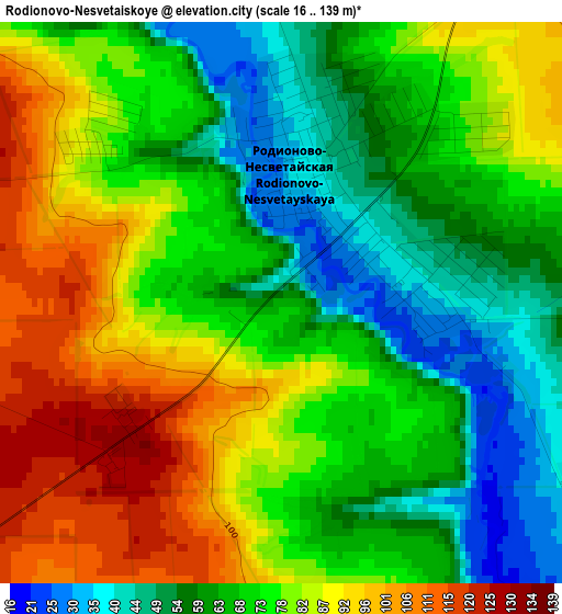
Below is the Elevation map of Rodionovo-Nesvetaiskoye, which displays elevation range with different colors. Scale of the first map is from 16 to 139 m (52 to 456 ft) with average elevation of 73.7 meters (=242 ft) [note 1]
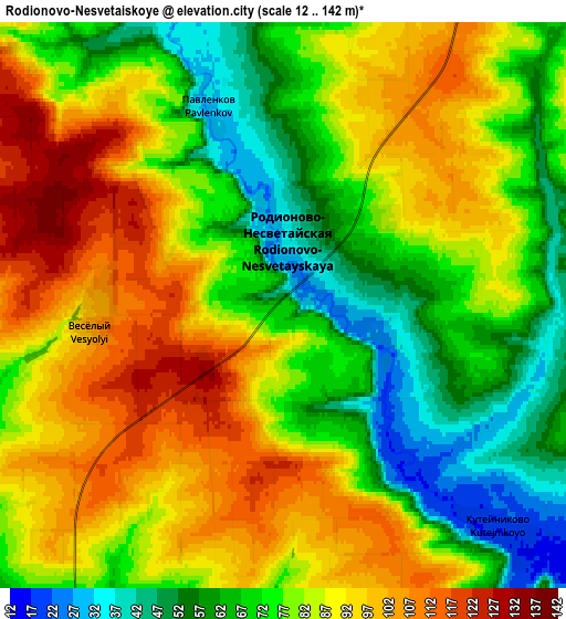
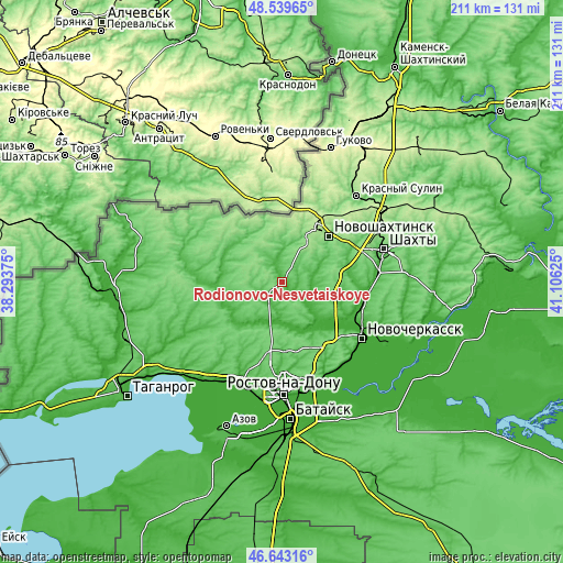
These maps also provides idea of topography and contour of this city, they are displayed at different zoom levels. More info about maps, scale and edge coordinates you can find below images.
| \ | Map #1 | Map #2 | Topo.Map |
| Scale [m] | 16..139 m | 12..142 m | × |
| Scale [ft] | 52..456 ft | 39..466 ft | × |
| Average | 73.7 m = 242 ft | 80.6 m = 264 ft | × |
| Width | 6.59 km = 4.1 mi | 13.18 km = 8.2 mi | 210.9 km = 131 mi |
| Height | 6.59 km = 4.1 mi | 13.18 km = 8.2 mi | 210.9 km = 131 mi |
| ↑Max Latitude | 47.629624° | 47.659231° | 48.53965° |
| Latitude at center | 47.6° | 47.6° | 47.6° |
| ↓Min Latitude | 47.570359° | 47.540702° | 46.64316° |
| ← Min Longitude | 39.656055° | 39.612109° | 38.29375° |
| Longitude center | 39.7° | 39.7° | 39.7° |
| →Max Longitude | 39.743945° | 39.787891° | 41.10625° |
Nearby cities:
Cities around Rodionovo-Nesvetaiskoye sort by population:
• Novocherkassk elevation 85 m
35.5 km,  124°
124°
• Novoshakhtinsk 152 m
25 km,  44°
44°
• Persianovka 26 m
22.5 km,  249°
249°
• Kamenolomni 62 m
38.6 km,  78°
78°
• Mayskiy 129 m
32 km,  70°
70°
• Sokolovo-Kundryuchenskiy 126 m
32 km, 35°
• Rodionovo-Nesvetayskaya 41 m
1.5 km, 38°
• Talovyy 163 m
38.4 km,  52°
52°
• Sambek 144 m
18.7 km,  31°
31°
• Krym 48 m
36.1 km,  202°
202°
• Krasyukovskaya 16 m
31.1 km,  99°
99°
• Grushevskaya 10 m
25.9 km,  133°
133°
Multilingual:
 En español:
Rodionovo-Nesvetaiskoye elevación 67 m.
 En France:
Rodionovo-Nesvetaiskoye élévation 67 m.
 Auf Deutsch:
Rodionovo-Nesvetaiskoye höhe über dem Meeresspiegel ist 67 m.
 На русском:
Родионово-Несветаиское высота над уровнем моря 67 м
Sources and notes:
- [note 1] Map square and city borders are not equal. Map elevation data is calculated only from area inside that square.
- [src 1] Elevation data from geonames database provided with same terms of usage.
- [src 2] The elevation map of Rodionovo-Nesvetaiskoye is generated using elevation data from NASA's 3 arcsec (90m) resolution SRTM data.
- [src 3] Base (background) map © OpenStreetMap contributors tiles are generated by Geofabrik and OpenTopoMap.
Copyright & License:
This Rodionovo-Nesvetaiskoye Elevation Map is licensed under CC BY-SA. You may reuse any part from this page, if you give a proper credit by linking to this URL:
 More info on terms of use page.