Sandovo elevation
Sandovo (Tver’ Oblast), Russia elevation is 158 meters and Sandovo elevation in feet is 518 ft above sea level [src 1]. Sandovo is a populated place (feature code) with elevation that is 41 meters (135 ft) smaller than average city elevation in Russia.
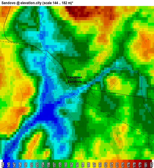
Below is the Elevation map of Sandovo, which displays elevation range with different colors. Scale of the first map is from 144 to 182 m (472 to 597 ft) with average elevation of 159.5 meters (=523 ft) [note 1]
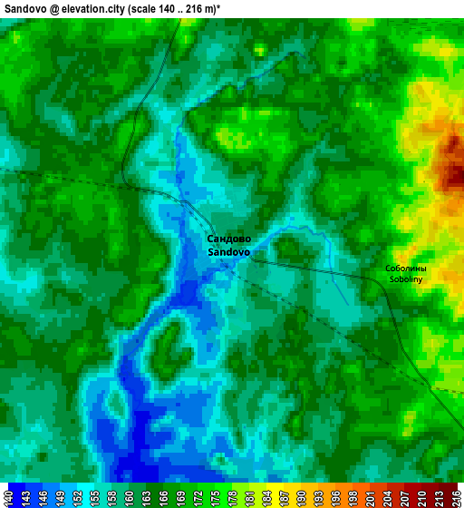
These maps also provides idea of topography and contour of this city, they are displayed at different zoom levels. More info about maps, scale and edge coordinates you can find below images.
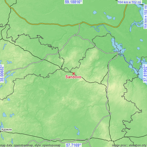
| \ | Map #1 | Map #2 | Topo.Map |
| Scale [m] | 144..182 m | 140..216 m | × |
| Scale [ft] | 472..597 ft | 459..709 ft | × |
| Average | 159.5 m = 523 ft | 164 m = 538 ft | × |
| Width | 5.11 km = 3.2 mi | 10.22 km = 6.4 mi | 163.6 km = 101.7 mi |
| Height | 5.11 km = 3.2 mi | 10.22 km = 6.4 mi | 163.6 km = 101.7 mi |
| ↑Max Latitude | 58.4832° | 58.506165° | 59.18816° |
| Latitude at center | 58.46022° | 58.46022° | 58.46022° |
| ↓Min Latitude | 58.437225° | 58.414215° | 57.7169° |
| ← Min Longitude | 36.368825° | 36.324879° | 35.00652° |
| Longitude center | 36.41277° | 36.41277° | 36.41277° |
| →Max Longitude | 36.456715° | 36.500661° | 37.81902° |
Nearby cities:
Cities around Sandovo sort by population:
• Bezhetsk elevation 143 m
76.9 km,  167°
167°
• Pestovo 129 m
38.4 km,  292°
292°
• Kaduy 116 m
92.6 km,  27°
27°
• Ustyuzhna 118 m
42.2 km,  1°
1°
• Maksatikha 141 m
80 km,  202°
202°
• Ves’yegonsk 110 m
54.1 km,  65°
65°
• Krasnyy Kholm 159 m
60.7 km,  137°
137°
• Sonkovo 196 m
87.5 km,  150°
150°
• Breytovo 109 m
86.3 km,  101°
101°
• Molokovo 185 m
38.6 km, 147°
• Lesnoye 137 m
55.8 km,  249°
249°
• Imeni Zhelyabova 111 m
56 km,  10°
10°
Multilingual:
 En español:
Sandovo elevación 158 m.
 En France:
Sandovo élévation 158 m.


Sources and notes:
- [note 1] Map square and city borders are not equal. Map elevation data is calculated only from area inside that square.
- [src 1] Elevation data from geonames database provided with same terms of usage.
- [src 2] The elevation map of Sandovo is generated using elevation data from NASA's 3 arcsec (90m) resolution SRTM data.
- [src 3] Base (background) map © OpenStreetMap contributors tiles are generated by Geofabrik and OpenTopoMap.
Copyright & License:
This Sandovo Elevation Map is licensed under CC BY-SA. You may reuse any part from this page, if you give a proper credit by linking to this URL:
 More info on terms of use page.