Breytovo elevation
Breytovo (Jaroslavl), Russia elevation is 109 meters and Breytovo elevation in feet is 358 ft above sea level [src 1]. Breytovo is a populated place (feature code) with elevation that is 90 meters (295 ft) smaller than average city elevation in Russia.
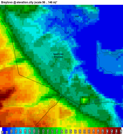
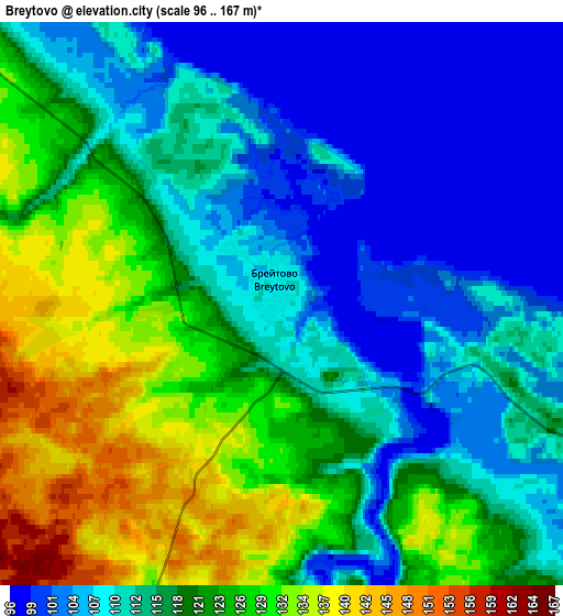
Below is the Elevation map of Breytovo, which displays elevation range with different colors. Scale of the first map is from 96 to 146 m (315 to 479 ft) with average elevation of 111.2 meters (=365 ft) [note 1]
These maps also provides idea of topography and contour of this city, they are displayed at different zoom levels. More info about maps, scale and edge coordinates you can find below images.
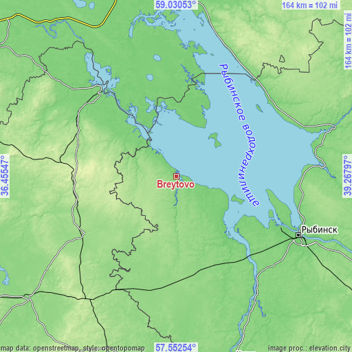
| \ | Map #1 | Map #2 | Topo.Map |
| Scale [m] | 96..146 m | 96..167 m | × |
| Scale [ft] | 315..479 ft | 315..548 ft | × |
| Average | 111.2 m = 365 ft | 116.8 m = 383 ft | × |
| Width | 5.14 km = 3.2 mi | 10.27 km = 6.4 mi | 164.3 km = 102.1 mi |
| Height | 5.14 km = 3.2 mi | 10.27 km = 6.4 mi | 164.3 km = 102.1 mi |
| ↑Max Latitude | 58.322335° | 58.345405° | 59.03053° |
| Latitude at center | 58.29925° | 58.29925° | 58.29925° |
| ↓Min Latitude | 58.27615° | 58.253035° | 57.55254° |
| ← Min Longitude | 37.817775° | 37.773829° | 36.45547° |
| Longitude center | 37.86172° | 37.86172° | 37.86172° |
| →Max Longitude | 37.905665° | 37.949611° | 39.26797° |
Nearby cities:
Cities around Breytovo sort by population:
• Rybinsk elevation 98 m
64.1 km,  116°
116°
• Ves’yegonsk 110 m
53.5 km,  319°
319°
• Poshekhon’ye 109 m
77.5 km,  73°
73°
• Krasnyy Kholm 159 m
50.9 km,  238°
238°
• Myshkin 121 m
66.5 km,  148°
148°
• Sonkovo 196 m
71.3 km,  215°
215°
• Novyy Nekouz 141 m
45.7 km,  164°
164°
• Volga 123 m
49.5 km,  141°
141°
• Molokovo 185 m
66 km,  257°
257°
• Sudoverf’ 110 m
50 km,  113°
113°
• Borok 116 m
34 km, 139°
• Myaksa 134 m
68.3 km,  16°
16°
Multilingual:
 En español:
Breytovo elevación 109 m.
 En France:
Breytovo élévation 109 m.
 Auf Deutsch:
Breytovo höhe über dem Meeresspiegel ist 109 m.

Sources and notes:
- [note 1] Map square and city borders are not equal. Map elevation data is calculated only from area inside that square.
- [src 1] Elevation data from geonames database provided with same terms of usage.
- [src 2] The elevation map of Breytovo is generated using elevation data from NASA's 3 arcsec (90m) resolution SRTM data.
- [src 3] Base (background) map © OpenStreetMap contributors tiles are generated by Geofabrik and OpenTopoMap.
Copyright & License:
This Breytovo Elevation Map is licensed under CC BY-SA. You may reuse any part from this page, if you give a proper credit by linking to this URL:
 More info on terms of use page.