Severnoye elevation
Severnoye (Stavropol’ Kray), Russia elevation is 430 meters and Severnoye elevation in feet is 1411 ft above sea level [src 1]. Severnoye is a populated place (feature code) with elevation that is 231 meters (758 ft) bigger than average city elevation in Russia.
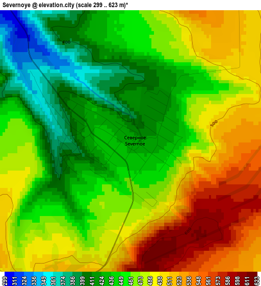
Below is the Elevation map of Severnoye, which displays elevation range with different colors. Scale of the first map is from 299 to 623 m (981 to 2044 ft) with average elevation of 467.8 meters (=1535 ft) [note 1]
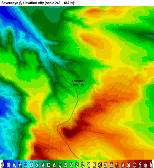
These maps also provides idea of topography and contour of this city, they are displayed at different zoom levels. More info about maps, scale and edge coordinates you can find below images.
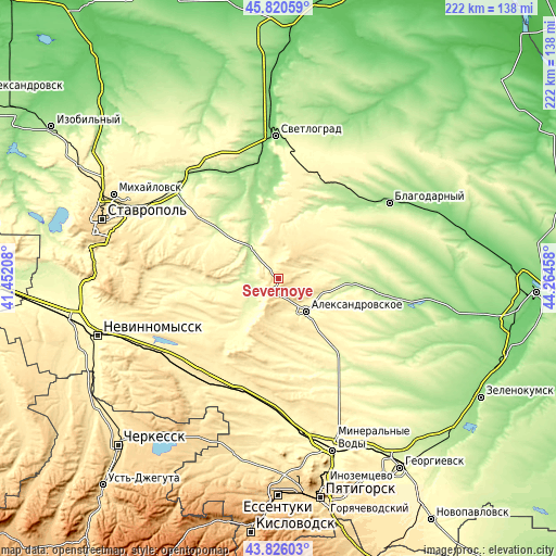
| \ | Map #1 | Map #2 | Topo.Map |
| Scale [m] | 299..623 m | 249..667 m | × |
| Scale [ft] | 981..2044 ft | 817..2188 ft | × |
| Average | 467.8 m = 1535 ft | 461.5 m = 1514 ft | × |
| Width | 6.93 km = 4.3 mi | 13.86 km = 8.6 mi | 221.8 km = 137.8 mi |
| Height | 6.93 km = 4.3 mi | 13.86 km = 8.6 mi | 221.8 km = 137.8 mi |
| ↑Max Latitude | 44.863097° | 44.894236° | 45.82059° |
| Latitude at center | 44.83194° | 44.83194° | 44.83194° |
| ↓Min Latitude | 44.800767° | 44.769576° | 43.82603° |
| ← Min Longitude | 42.814385° | 42.770439° | 41.45208° |
| Longitude center | 42.85833° | 42.85833° | 42.85833° |
| →Max Longitude | 42.902275° | 42.946221° | 44.26458° |
Nearby cities:
Cities around Severnoye sort by population:
• Aleksandrovskoye elevation 295 m
17.3 km,  139°
139°
• Gofitskoye 218 m
31.2 km,  28°
28°
• Aleksandriya 174 m
42.2 km,  46°
46°
• Beshpagir 342 m
43.1 km,  299°
299°
• Kalinovskoye 370 m
8.9 km,  66°
66°
• Sukhaya Buyvola 278 m
37.3 km,  16°
16°
• Spitsevka 249 m
42.3 km,  319°
319°
• Yelizavetinskoye 205 m
43.3 km,  63°
63°
• Kruglolesskoye 452 m
19.6 km,  190°
190°
• Nagutskoye 451 m
43.4 km,  178°
178°
• Vysotskoye 347 m
21.8 km,  9°
9°
• Grecheskoye 350 m
46.2 km,  165°
165°
Multilingual:
 En español:
Severnoye elevación 430 m.
 En France:
Severnoye élévation 430 m.
 Auf Deutsch:
Severnoye höhe über dem Meeresspiegel ist 430 m.

Sources and notes:
- [note 1] Map square and city borders are not equal. Map elevation data is calculated only from area inside that square.
- [src 1] Elevation data from geonames database provided with same terms of usage.
- [src 2] The elevation map of Severnoye is generated using elevation data from NASA's 3 arcsec (90m) resolution SRTM data.
- [src 3] Base (background) map © OpenStreetMap contributors tiles are generated by Geofabrik and OpenTopoMap.
Copyright & License:
This Severnoye Elevation Map is licensed under CC BY-SA. You may reuse any part from this page, if you give a proper credit by linking to this URL:
 More info on terms of use page.