Grecheskoye elevation
Grecheskoye (Stavropol’ Kray), Russia elevation is 350 meters and Grecheskoye elevation in feet is 1148 ft above sea level [src 1]. Grecheskoye is a populated place (feature code) with elevation that is 151 meters (495 ft) bigger than average city elevation in Russia.
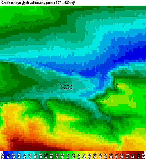
Below is the Elevation map of Grecheskoye, which displays elevation range with different colors. Scale of the first map is from 307 to 539 m (1007 to 1768 ft) with average elevation of 388.1 meters (=1273 ft) [note 1]
These maps also provides idea of topography and contour of this city, they are displayed at different zoom levels. More info about maps, scale and edge coordinates you can find below images.
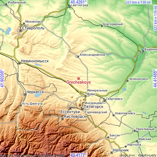
| \ | Map #1 | Topo.Map |
| Scale [m] | 307..539 m | × |
| Scale [ft] | 1007..1768 ft | × |
| Average | 388.1 m = 1273 ft | × |
| Width | 6.98 km = 4.3 mi | 223.3 km = 138.8 mi |
| Height | 6.98 km = 4.3 mi | 223.3 km = 138.8 mi |
| ↑Max Latitude | 44.461903° | 45.4261° |
| Latitude at center | 44.43053° | 44.43053° |
| ↓Min Latitude | 44.39914° | 43.4177° |
| ← Min Longitude | 42.964355° | 41.60205° |
| Longitude center | 43.0083° | 43.0083° |
| →Max Longitude | 43.052245° | 44.41455° |
Nearby cities:
Cities around Grecheskoye sort by population:
• Mineralnye Vody elevation 310 m
26.5 km,  157°
157°
• Aleksandrovskoye 295 m
31.5 km,  358°
358°
• Zheleznovodsk 585 m
32.4 km,  178°
178°
• Andzhiyevskiy 306 m
22.2 km, 163°
• Levokumka 297 m
24.8 km,  152°
152°
• Kangly 312 m
19.7 km,  174°
174°
• Soluno-Dmitriyevskoye 357 m
22.7 km,  263°
263°
• Kruglolesskoye 452 m
29.7 km,  328°
328°
• Nagutskoye 451 m
10.6 km,  276°
276°
• Grazhdanskoye 395 m
29.3 km,  220°
220°
• Zmeyka 345 m
33.2 km, 164°
• Novoterskiy 396 m
32.1 km, 167°
Multilingual:
 En español:
Grecheskoye elevación 350 m.
 En France:
Grecheskoye élévation 350 m.
 Auf Deutsch:
Grecheskoye höhe über dem Meeresspiegel ist 350 m.

Sources and notes:
- [note 1] Map square and city borders are not equal. Map elevation data is calculated only from area inside that square.
- [src 1] Elevation data from geonames database provided with same terms of usage.
- [src 2] The elevation map of Grecheskoye is generated using elevation data from NASA's 3 arcsec (90m) resolution SRTM data.
- [src 3] Base (background) map © OpenStreetMap contributors tiles are generated by Geofabrik and OpenTopoMap.
Copyright & License:
This Grecheskoye Elevation Map is licensed under CC BY-SA. You may reuse any part from this page, if you give a proper credit by linking to this URL:
 More info on terms of use page.