Shemordan elevation
Shemordan (Tatarstan Republic), Russia elevation is 194 meters and Shemordan elevation in feet is 636 ft above sea level [src 1]. Shemordan is a populated place (feature code) with elevation that is 5 meters (16 ft) smaller than average city elevation in Russia.
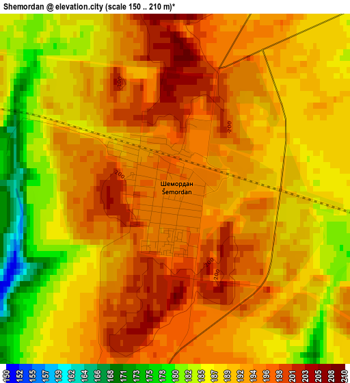
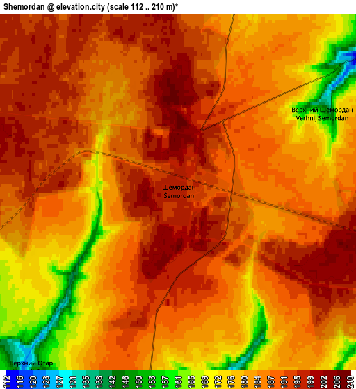
Below is the Elevation map of Shemordan, which displays elevation range with different colors. Scale of the first map is from 150 to 210 m (492 to 689 ft) with average elevation of 190.7 meters (=626 ft) [note 1]
These maps also provides idea of topography and contour of this city, they are displayed at different zoom levels. More info about maps, scale and edge coordinates you can find below images.
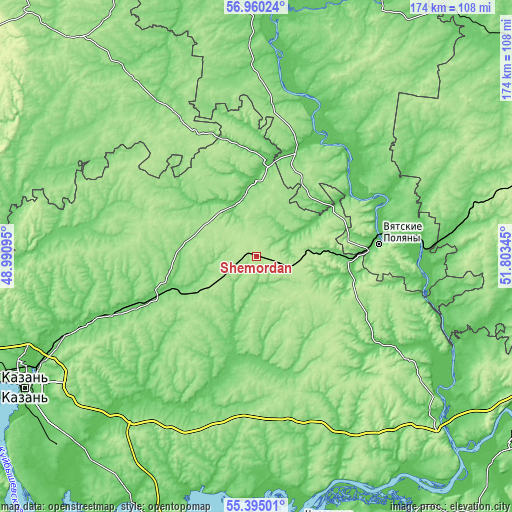
| \ | Map #1 | Map #2 | Topo.Map |
| Scale [m] | 150..210 m | 112..210 m | × |
| Scale [ft] | 492..689 ft | 367..689 ft | × |
| Average | 190.7 m = 626 ft | 185.1 m = 607 ft | × |
| Width | 5.44 km = 3.4 mi | 10.88 km = 6.8 mi | 174 km = 108.1 mi |
| Height | 5.44 km = 3.4 mi | 10.88 km = 6.8 mi | 174 km = 108.1 mi |
| ↑Max Latitude | 56.210048° | 56.23448° | 56.96024° |
| Latitude at center | 56.1856° | 56.1856° | 56.1856° |
| ↓Min Latitude | 56.161136° | 56.136657° | 55.39501° |
| ← Min Longitude | 50.353255° | 50.309309° | 48.99095° |
| Longitude center | 50.3972° | 50.3972° | 50.3972° |
| →Max Longitude | 50.441145° | 50.485091° | 51.80345° |
Nearby cities:
Cities around Shemordan sort by population:
• Vyatskiye Polyany elevation 74 m
41.6 km,  83°
83°
• Arsk 136 m
33.8 km,  251°
251°
• Kukmor 102 m
30.8 km,  90°
90°
• Sosnovka 91 m
55.4 km, 81°
• Kizner 76 m
69.4 km, 81°
• Malmyzh 76 m
41.2 km,  25°
25°
• Krasnaya Polyana 65 m
46.6 km, 82°
• Pestretsy 98 m
66.7 km,  223°
223°
• Bogatyye Saby 152 m
19.8 km,  170°
170°
• Baltasi 104 m
21.4 km,  326°
326°
• Tyulyachi 99 m
34.2 km,  196°
196°
• Lubyany 60 m
64.3 km,  104°
104°
Multilingual:
 En español:
Shemordan elevación 194 m.
 En France:
Shemordan élévation 194 m.
 Auf Deutsch:
Shemordan höhe über dem Meeresspiegel ist 194 m.

Sources and notes:
- [note 1] Map square and city borders are not equal. Map elevation data is calculated only from area inside that square.
- [src 1] Elevation data from geonames database provided with same terms of usage.
- [src 2] The elevation map of Shemordan is generated using elevation data from NASA's 3 arcsec (90m) resolution SRTM data.
- [src 3] Base (background) map © OpenStreetMap contributors tiles are generated by Geofabrik and OpenTopoMap.
Copyright & License:
This Shemordan Elevation Map is licensed under CC BY-SA. You may reuse any part from this page, if you give a proper credit by linking to this URL:
 More info on terms of use page.