Snegiri elevation
Snegiri (Moscow Oblast), Russia elevation is 216 meters and Snegiri elevation in feet is 709 ft above sea level [src 1]. Snegiri is a populated place (feature code) with elevation that is 17 meters (56 ft) bigger than average city elevation in Russia.
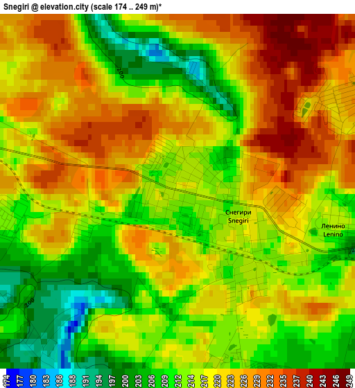
Below is the Elevation map of Snegiri, which displays elevation range with different colors. Scale of the first map is from 174 to 249 m (571 to 817 ft) with average elevation of 218 meters (=715 ft) [note 1]
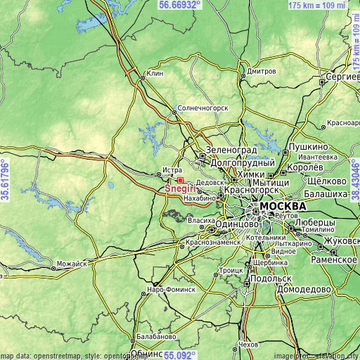
These maps also provides idea of topography and contour of this city, they are displayed at different zoom levels. More info about maps, scale and edge coordinates you can find below images.
| \ | Map #1 | Topo.Map |
| Scale [m] | 174..249 m | × |
| Scale [ft] | 571..817 ft | × |
| Average | 218 m = 715 ft | × |
| Width | 5.48 km = 3.4 mi | 175.4 km = 109 mi |
| Height | 5.48 km = 3.4 mi | 175.4 km = 109 mi |
| ↑Max Latitude | 55.913307° | 56.66932° |
| Latitude at center | 55.88867° | 55.88867° |
| ↓Min Latitude | 55.864018° | 55.092° |
| ← Min Longitude | 36.980265° | 35.61796° |
| Longitude center | 37.02421° | 37.02421° |
| →Max Longitude | 37.068155° | 38.43046° |
Nearby cities:
Cities around Snegiri sort by population:
• Zelenograd elevation 220 m
14.3 km,  43°
43°
• Istra 175 m
10.3 km,  289°
289°
• Nakhabino 183 m
10.6 km,  114°
114°
• Dedovsk 192 m
6.5 km, 110°
• Yershovo 205 m
16.8 km,  217°
217°
• Andreyevka 218 m
12.3 km,  34°
34°
• Nikolina Gora 175 m
17.2 km,  175°
175°
• Pavlovskaya Sloboda 161 m
8.9 km,  156°
156°
• Opalikha 188 m
15.9 km,  116°
116°
• Rozhdestveno 184 m
4.1 km, 157°
• Firsanovka 200 m
15.3 km,  61°
61°
• Alabushevo 224 m
16.2 km, 28°
Multilingual:
 En español:
Snegiri elevación 216 m.
 En France:
Snegiri élévation 216 m.


Sources and notes:
- [note 1] Map square and city borders are not equal. Map elevation data is calculated only from area inside that square.
- [src 1] Elevation data from geonames database provided with same terms of usage.
- [src 2] The elevation map of Snegiri is generated using elevation data from NASA's 3 arcsec (90m) resolution SRTM data.
- [src 3] Base (background) map © OpenStreetMap contributors tiles are generated by Geofabrik and OpenTopoMap.
Copyright & License:
This Snegiri Elevation Map is licensed under CC BY-SA. You may reuse any part from this page, if you give a proper credit by linking to this URL:
 More info on terms of use page.