Soldatskaya elevation
Soldatskaya (Kabardino-Balkariya Republic), Russia elevation is 270 meters and Soldatskaya elevation in feet is 886 ft above sea level [src 1]. Soldatskaya is a populated place (feature code) with elevation that is 71 meters (233 ft) bigger than average city elevation in Russia.
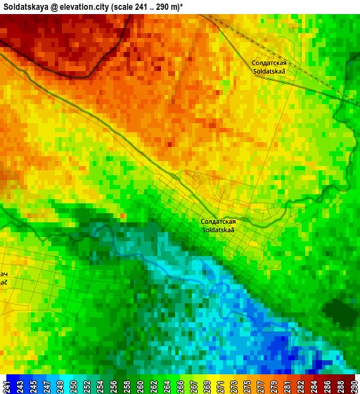
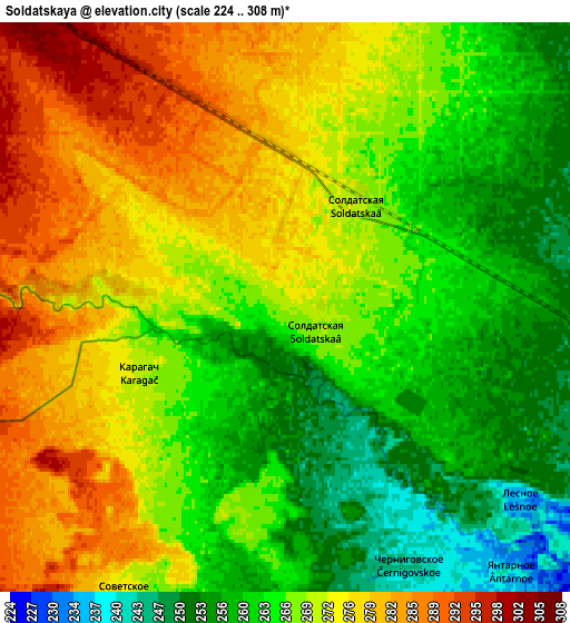
Below is the Elevation map of Soldatskaya, which displays elevation range with different colors. Scale of the first map is from 241 to 290 m (791 to 951 ft) with average elevation of 266.6 meters (=875 ft) [note 1]
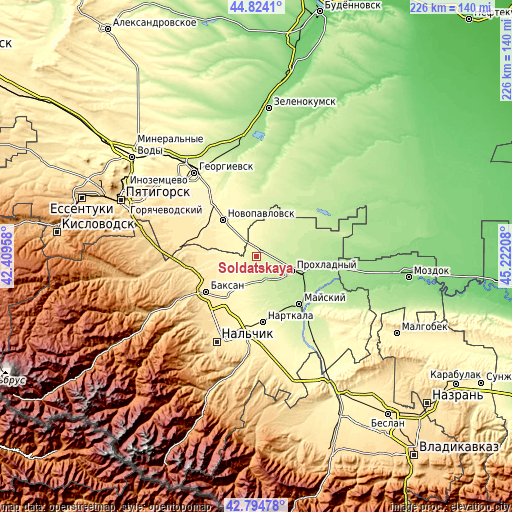
These maps also provides idea of topography and contour of this city, they are displayed at different zoom levels. More info about maps, scale and edge coordinates you can find below images.
| \ | Map #1 | Map #2 | Topo.Map |
| Scale [m] | 241..290 m | 224..308 m | × |
| Scale [ft] | 791..951 ft | 735..1010 ft | × |
| Average | 266.6 m = 875 ft | 268.6 m = 881 ft | × |
| Width | 7.05 km = 4.4 mi | 14.1 km = 8.8 mi | 225.6 km = 140.2 mi |
| Height | 7.05 km = 4.4 mi | 14.1 km = 8.8 mi | 225.6 km = 140.2 mi |
| ↑Max Latitude | 43.84976° | 43.881443° | 44.8241° |
| Latitude at center | 43.81806° | 43.81806° | 43.81806° |
| ↓Min Latitude | 43.786343° | 43.75461° | 42.79478° |
| ← Min Longitude | 43.771885° | 43.727939° | 42.40958° |
| Longitude center | 43.81583° | 43.81583° | 43.81583° |
| →Max Longitude | 43.859775° | 43.903721° | 45.22208° |
Nearby cities:
Cities around Soldatskaya sort by population:
• Prokhladnyy elevation 208 m
18.4 km,  111°
111°
• Baksan 451 m
26.7 km,  237°
237°
• Novopavlovsk 331 m
21.7 km,  317°
317°
• Dugulubgey 450 m
28.3 km,  232°
232°
• Baksanenok 354 m
19.3 km,  222°
222°
• Karagach 269 m
3.6 km,  246°
246°
• Altud 237 m
11.4 km,  159°
159°
• Primalkinskoye 207 m
17.4 km,  117°
117°
• Kishpek 359 m
22.9 km, 217°
• Germenchik 298 m
25.2 km,  189°
189°
• Staropavlovskaya 328 m
15.1 km,  283°
283°
• Mayskiy 211 m
26.6 km,  137°
137°
Multilingual:
 En español:
Soldatskaya elevación 270 m.
 En France:
Soldatskaya élévation 270 m.
 Auf Deutsch:
Soldatskaya höhe über dem Meeresspiegel ist 270 m.

Sources and notes:
- [note 1] Map square and city borders are not equal. Map elevation data is calculated only from area inside that square.
- [src 1] Elevation data from geonames database provided with same terms of usage.
- [src 2] The elevation map of Soldatskaya is generated using elevation data from NASA's 3 arcsec (90m) resolution SRTM data.
- [src 3] Base (background) map © OpenStreetMap contributors tiles are generated by Geofabrik and OpenTopoMap.
Copyright & License:
This Soldatskaya Elevation Map is licensed under CC BY-SA. You may reuse any part from this page, if you give a proper credit by linking to this URL:
 More info on terms of use page.