Solntsevo elevation
Solntsevo (Kursk), Russia elevation is 170 meters and Solntsevo elevation in feet is 558 ft above sea level [src 1]. Solntsevo is a populated place (feature code) with elevation that is 29 meters (95 ft) smaller than average city elevation in Russia.
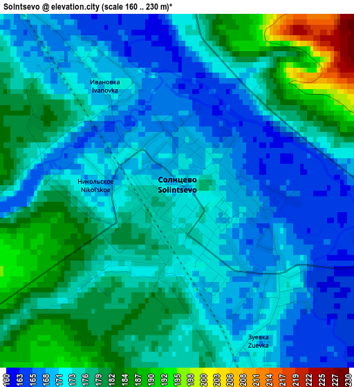
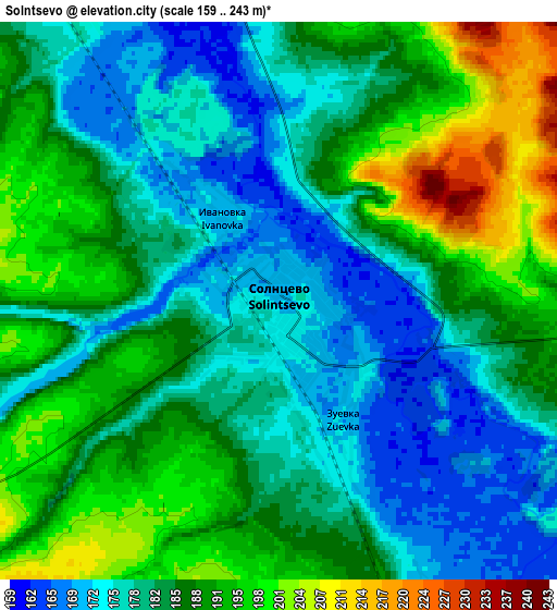
Below is the Elevation map of Solntsevo, which displays elevation range with different colors. Scale of the first map is from 160 to 230 m (525 to 755 ft) with average elevation of 174.8 meters (=573 ft) [note 1]
These maps also provides idea of topography and contour of this city, they are displayed at different zoom levels. More info about maps, scale and edge coordinates you can find below images.
| \ | Map #1 | Map #2 | Topo.Map |
| Scale [m] | 160..230 m | 159..243 m | × |
| Scale [ft] | 525..755 ft | 522..797 ft | × |
| Average | 174.8 m = 573 ft | 184.3 m = 605 ft | × |
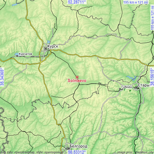
| Width | 6.09 km = 3.8 mi | 12.19 km = 7.6 mi | 195 km = 121.2 mi |
| Height | 6.09 km = 3.8 mi | 12.19 km = 7.6 mi | 195 km = 121.2 mi |
| ↑Max Latitude | 51.445927° | 51.473308° | 52.28711° |
| Latitude at center | 51.41853° | 51.41853° | 51.41853° |
| ↓Min Latitude | 51.391116° | 51.363686° | 50.53312° |
| ← Min Longitude | 36.705955° | 36.662009° | 35.34365° |
| Longitude center | 36.7499° | 36.7499° | 36.7499° |
| →Max Longitude | 36.793845° | 36.837791° | 38.15615° |
Nearby cities:
Cities around Solntsevo sort by population:
• Kursk elevation 219 m
52.6 km,  312°
312°
• Shchigry 221 m
51.9 km,  11°
11°
• Oboyan’ 189 m
40.1 km,  234°
234°
• Prokhorovka 256 m
42.4 km,  181°
181°
• Troitskiy 241 m
54.2 km,  97°
97°
• Pristen’ 243 m
20.7 km,  190°
190°
• Skorodnoye 227 m
51 km,  139°
139°
• Tim 261 m
34.4 km,  48°
48°
• Voroshnëvo 165 m
57 km,  297°
297°
• Kirovskiy 177 m
5.8 km,  267°
267°
• Chernitsyno 247 m
49.4 km,  281°
281°
• Manturovo 206 m
26.5 km,  81°
81°
Multilingual:
 En español:
Solntsevo elevación 170 m.
 En France:
Solntsevo élévation 170 m.
 Auf Deutsch:
Solntsevo höhe über dem Meeresspiegel ist 170 m.

Sources and notes:
- [note 1] Map square and city borders are not equal. Map elevation data is calculated only from area inside that square.
- [src 1] Elevation data from geonames database provided with same terms of usage.
- [src 2] The elevation map of Solntsevo is generated using elevation data from NASA's 3 arcsec (90m) resolution SRTM data.
- [src 3] Base (background) map © OpenStreetMap contributors tiles are generated by Geofabrik and OpenTopoMap.
Copyright & License:
This Solntsevo Elevation Map is licensed under CC BY-SA. You may reuse any part from this page, if you give a proper credit by linking to this URL:
 More info on terms of use page.