Sudislavl’ elevation
Sudislavl’ (Kostroma Oblast), Russia elevation is 128 meters and Sudislavl’ elevation in feet is 420 ft above sea level [src 1]. Sudislavl’ is a populated place (feature code) with elevation that is 71 meters (233 ft) smaller than average city elevation in Russia.
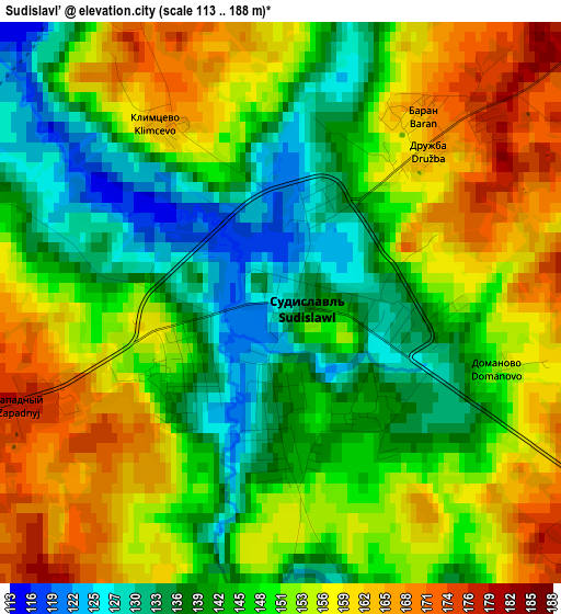
Below is the Elevation map of Sudislavl’, which displays elevation range with different colors. Scale of the first map is from 113 to 188 m (371 to 617 ft) with average elevation of 149.2 meters (=490 ft) [note 1]
These maps also provides idea of topography and contour of this city, they are displayed at different zoom levels. More info about maps, scale and edge coordinates you can find below images.

| \ | Map #1 | Map #2 | Topo.Map |
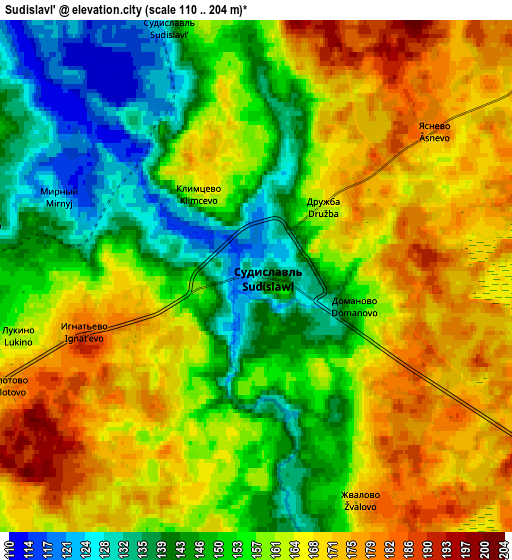
| Scale [m] | 113..188 m | 110..204 m | × |
| Scale [ft] | 371..617 ft | 361..669 ft | × |
| Average | 149.2 m = 490 ft | 158.6 m = 520 ft | × |
| Width | 5.2 km = 3.2 mi | 10.39 km = 6.5 mi | 166.3 km = 103.3 mi |
| Height | 5.2 km = 3.2 mi | 10.39 km = 6.5 mi | 166.3 km = 103.3 mi |
| ↑Max Latitude | 57.905107° | 57.928448° | 58.62167° |
| Latitude at center | 57.88175° | 57.88175° | 57.88175° |
| ↓Min Latitude | 57.858378° | 57.834991° | 57.12629° |
| ← Min Longitude | 41.664345° | 41.620399° | 40.30204° |
| Longitude center | 41.70829° | 41.70829° | 41.70829° |
| →Max Longitude | 41.752235° | 41.796181° | 43.11454° |
Nearby cities:
Cities around Sudislavl’ sort by population:
• Kostroma elevation 109 m
48 km,  254°
254°
• Kineshma 109 m
55.2 km,  153°
153°
• Zavolzhsk 129 m
51.2 km, 150°
• Navoloki 122 m
48.7 km,  161°
161°
• Krasnoye-na-Volge 126 m
49.4 km,  214°
214°
• Ostrovskoye 136 m
32.8 km,  104°
104°
• Chistyye Bory 111 m
53.9 km,  354°
354°
• Kamenka 99 m
54.7 km,  174°
174°
• Susanino 158 m
30.4 km, 347°
• Plës 132 m
48.4 km,  193°
193°
• Zarechnyy 88 m
57.2 km,  143°
143°
• Oktyabr’skiy 136 m
44.5 km, 249°
Multilingual:
 En español:
Sudislavl’ elevación 128 m.
 En France:
Sudislavl’ élévation 128 m.
 Auf Deutsch:
Sudislavl’ höhe über dem Meeresspiegel ist 128 m.

Sources and notes:
- [note 1] Map square and city borders are not equal. Map elevation data is calculated only from area inside that square.
- [src 1] Elevation data from geonames database provided with same terms of usage.
- [src 2] The elevation map of Sudislavl’ is generated using elevation data from NASA's 3 arcsec (90m) resolution SRTM data.
- [src 3] Base (background) map © OpenStreetMap contributors tiles are generated by Geofabrik and OpenTopoMap.
Copyright & License:
This Sudislavl’ Elevation Map is licensed under CC BY-SA. You may reuse any part from this page, if you give a proper credit by linking to this URL:
 More info on terms of use page.