Tashla elevation
Tashla (Orenburg Oblast), Russia elevation is 72 meters and Tashla elevation in feet is 236 ft above sea level [src 1]. Tashla is a populated place (feature code) with elevation that is 127 meters (417 ft) smaller than average city elevation in Russia.
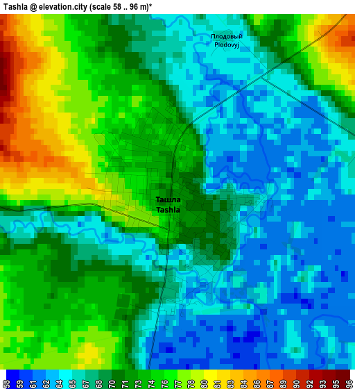
Below is the Elevation map of Tashla, which displays elevation range with different colors. Scale of the first map is from 58 to 96 m (190 to 315 ft) with average elevation of 70 meters (=230 ft) [note 1]
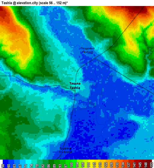
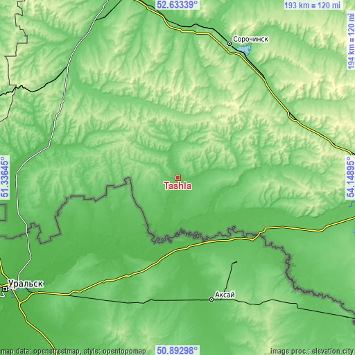
These maps also provides idea of topography and contour of this city, they are displayed at different zoom levels. More info about maps, scale and edge coordinates you can find below images.
| \ | Map #1 | Map #2 | Topo.Map |
| Scale [m] | 58..96 m | 56..152 m | × |
| Scale [ft] | 190..315 ft | 184..499 ft | × |
| Average | 70 m = 230 ft | 79.8 m = 262 ft | × |
| Width | 6.05 km = 3.8 mi | 12.09 km = 7.5 mi | 193.5 km = 120.2 mi |
| Height | 6.05 km = 3.8 mi | 12.09 km = 7.5 mi | 193.5 km = 120.2 mi |
| ↑Max Latitude | 51.798755° | 51.825924° | 52.63339° |
| Latitude at center | 51.77157° | 51.77157° | 51.77157° |
| ↓Min Latitude | 51.744369° | 51.717151° | 50.89298° |
| ← Min Longitude | 52.698755° | 52.654809° | 51.33645° |
| Longitude center | 52.7427° | 52.7427° | 52.7427° |
| →Max Longitude | 52.786645° | 52.830591° | 54.14895° |
Nearby cities:
Cities around Tashla sort by population:
• Buzuluk elevation 73 m
116.8 km,  343°
343°
• Sorochinsk 100 m
78.9 km,  21°
21°
• Novosergiyevka 129 m
71.9 km,  60°
60°
• Ilek 64 m
51.9 km,  121°
121°
• Perevolotskiy 179 m
100.4 km,  83°
83°
• Totskoye 80 m
83.8 km,  0°
0°
• Krasnokholm 78 m
99.4 km,  101°
101°
• Kurmanayevka 80 m
94.1 km,  330°
330°
• Krasnogvardeyets 71 m
104.3 km,  345°
345°
• Koltubanovskiy 63 m
138.8 km, 339°
• Pleshanovo 132 m
128.3 km, 23°
• Kardailovo 72 m
84.2 km,  107°
107°
Multilingual:
 En español:
Tashla elevación 72 m.
 En France:
Tashla élévation 72 m.


Sources and notes:
- [note 1] Map square and city borders are not equal. Map elevation data is calculated only from area inside that square.
- [src 1] Elevation data from geonames database provided with same terms of usage.
- [src 2] The elevation map of Tashla is generated using elevation data from NASA's 3 arcsec (90m) resolution SRTM data.
- [src 3] Base (background) map © OpenStreetMap contributors tiles are generated by Geofabrik and OpenTopoMap.
Copyright & License:
This Tashla Elevation Map is licensed under CC BY-SA. You may reuse any part from this page, if you give a proper credit by linking to this URL:
 More info on terms of use page.