Perevolotskiy elevation
Perevolotskiy (Orenburg Oblast), Russia elevation is 179 meters and Perevolotskiy elevation in feet is 587 ft above sea level [src 1]. Perevolotskiy is a populated place (feature code) with elevation that is 20 meters (66 ft) smaller than average city elevation in Russia.
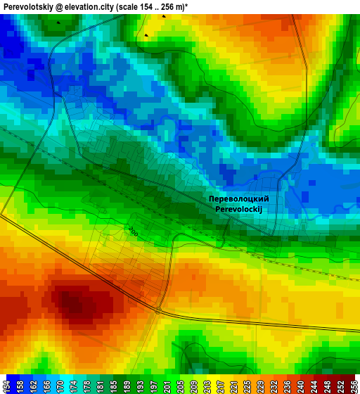
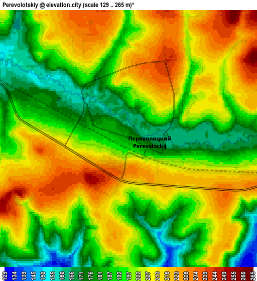
Below is the Elevation map of Perevolotskiy, which displays elevation range with different colors. Scale of the first map is from 154 to 256 m (505 to 840 ft) with average elevation of 198.6 meters (=652 ft) [note 1]
These maps also provides idea of topography and contour of this city, they are displayed at different zoom levels. More info about maps, scale and edge coordinates you can find below images.
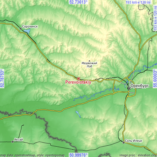
| \ | Map #1 | Map #2 | Topo.Map |
| Scale [m] | 154..256 m | 129..265 m | × |
| Scale [ft] | 505..840 ft | 423..869 ft | × |
| Average | 198.6 m = 652 ft | 200.3 m = 657 ft | × |
| Width | 6.03 km = 3.7 mi | 12.07 km = 7.5 mi | 193.1 km = 120 mi |
| Height | 6.03 km = 3.7 mi | 12.07 km = 7.5 mi | 193 km = 119.9 mi |
| ↑Max Latitude | 51.903452° | 51.930558° | 52.73613° |
| Latitude at center | 51.87633° | 51.87633° | 51.87633° |
| ↓Min Latitude | 51.849192° | 51.822037° | 50.99976° |
| ← Min Longitude | 54.149835° | 54.105889° | 52.78753° |
| Longitude center | 54.19378° | 54.19378° | 54.19378° |
| →Max Longitude | 54.237725° | 54.281671° | 55.60003° |
Nearby cities:
Cities around Perevolotskiy sort by population:
• Orenburg elevation 107 m
63.3 km,  100°
100°
• Novosergiyevka 129 m
44.2 km,  303°
303°
• Ilek 64 m
68 km,  235°
235°
• Krasnokholm 78 m
31.1 km,  184°
184°
• Nezhinka 100 m
81.7 km, 98°
• Sakmara 111 m
79.1 km,  81°
81°
• Krasnyy Kommunar 105 m
81 km, 83°
• Nizhnepavlovka 85 m
45.6 km,  113°
113°
• Tatarskaya Kargala 105 m
67.7 km, 83°
• Prigorodnyy 98 m
74.7 km, 99°
• Podgorodnyaya Pokrovka 102 m
54.8 km, 95°
• Kardailovo 72 m
42.5 km,  207°
207°
Multilingual:
 En español:
Perevolotskiy elevación 179 m.
 En France:
Perevolotskiy élévation 179 m.
 Auf Deutsch:
Perevolotskiy höhe über dem Meeresspiegel ist 179 m.
 На русском:
Переволоцкий, Переволотский высота над уровнем моря 179 м
Sources and notes:
- [note 1] Map square and city borders are not equal. Map elevation data is calculated only from area inside that square.
- [src 1] Elevation data from geonames database provided with same terms of usage.
- [src 2] The elevation map of Perevolotskiy is generated using elevation data from NASA's 3 arcsec (90m) resolution SRTM data.
- [src 3] Base (background) map © OpenStreetMap contributors tiles are generated by Geofabrik and OpenTopoMap.
Copyright & License:
This Perevolotskiy Elevation Map is licensed under CC BY-SA. You may reuse any part from this page, if you give a proper credit by linking to this URL:
 More info on terms of use page.