Ulu-Telyak elevation
Ulu-Telyak (Bashkortostan Republic), Russia elevation is 131 meters and Ulu-Telyak elevation in feet is 430 ft above sea level [src 1]. Ulu-Telyak is a populated place (feature code) with elevation that is 68 meters (223 ft) smaller than average city elevation in Russia.
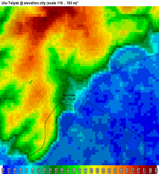
Below is the Elevation map of Ulu-Telyak, which displays elevation range with different colors. Scale of the first map is from 110 to 183 m (361 to 600 ft) with average elevation of 136.9 meters (=449 ft) [note 1]
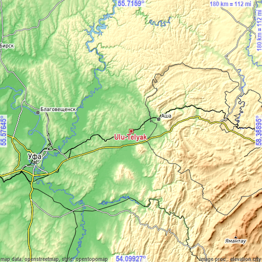
These maps also provides idea of topography and contour of this city, they are displayed at different zoom levels. More info about maps, scale and edge coordinates you can find below images.
| \ | Map #1 | Topo.Map |
| Scale [m] | 110..183 m | × |
| Scale [ft] | 361..600 ft | × |
| Average | 136.9 m = 449 ft | × |
| Width | 5.62 km = 3.5 mi | 179.8 km = 111.7 mi |
| Height | 5.62 km = 3.5 mi | 179.7 km = 111.7 mi |
| ↑Max Latitude | 54.940951° | 55.7159° |
| Latitude at center | 54.9157° | 54.9157° |
| ↓Min Latitude | 54.890433° | 54.09927° |
| ← Min Longitude | 56.938755° | 55.57645° |
| Longitude center | 56.9827° | 56.9827° |
| →Max Longitude | 57.026645° | 58.38895° |
Nearby cities:
Cities around Ulu-Telyak sort by population:
• Blagoveshchensk elevation 109 m
65.5 km,  281°
281°
• Asha 140 m
20.6 km,  63°
63°
• Sim 203 m
46.5 km,  79°
79°
• Iglino 114 m
37.6 km,  255°
255°
• Yazykovo 174 m
63.7 km,  302°
302°
• Kropachëvo 397 m
65.1 km, 80°
• Pavlovka 278 m
62.4 km,  334°
334°
• Krasnaya Gorka 122 m
37.1 km, 327°
• Kudeyevskiy 187 m
15.1 km,  252°
252°
• Urman 145 m
7.8 km,  242°
242°
• Krasnyy Klyuch 133 m
56.4 km,  338°
338°
• Bedeyeva Polyana 122 m
59 km,  320°
320°
Multilingual:
 En español:
Ulu-Telyak elevación 131 m.
 En France:
Ulu-Telyak élévation 131 m.
 Auf Deutsch:
Ulu-Telyak höhe über dem Meeresspiegel ist 131 m.

Sources and notes:
- [note 1] Map square and city borders are not equal. Map elevation data is calculated only from area inside that square.
- [src 1] Elevation data from geonames database provided with same terms of usage.
- [src 2] The elevation map of Ulu-Telyak is generated using elevation data from NASA's 3 arcsec (90m) resolution SRTM data.
- [src 3] Base (background) map © OpenStreetMap contributors tiles are generated by Geofabrik and OpenTopoMap.
Copyright & License:
This Ulu-Telyak Elevation Map is licensed under CC BY-SA. You may reuse any part from this page, if you give a proper credit by linking to this URL:
 More info on terms of use page.