Uvarovka elevation
Uvarovka (Moscow Oblast), Russia elevation is 258 meters and Uvarovka elevation in feet is 846 ft above sea level [src 1]. Uvarovka is a populated place (feature code) with elevation that is 59 meters (194 ft) bigger than average city elevation in Russia.
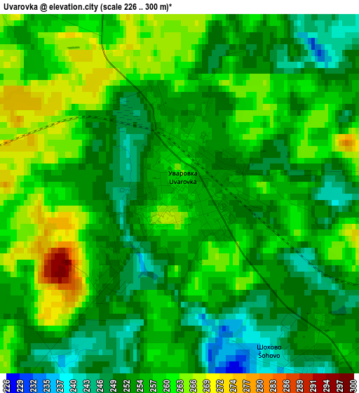
Below is the Elevation map of Uvarovka, which displays elevation range with different colors. Scale of the first map is from 226 to 300 m (741 to 984 ft) with average elevation of 255.9 meters (=840 ft) [note 1]
These maps also provides idea of topography and contour of this city, they are displayed at different zoom levels. More info about maps, scale and edge coordinates you can find below images.
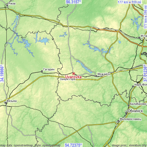
| \ | Map #1 | Topo.Map |
| Scale [m] | 226..300 m | × |
| Scale [ft] | 741..984 ft | × |
| Average | 255.9 m = 840 ft | × |
| Width | 5.53 km = 3.4 mi | 177 km = 110 mi |
| Height | 5.53 km = 3.4 mi | 177 km = 110 mi |
| ↑Max Latitude | 55.552645° | 56.3157° |
| Latitude at center | 55.52778° | 55.52778° |
| ↓Min Latitude | 55.502899° | 54.72375° |
| ← Min Longitude | 35.562165° | 34.19986° |
| Longitude center | 35.60611° | 35.60611° |
| →Max Longitude | 35.650055° | 37.01236° |
Nearby cities:
Cities around Uvarovka sort by population:
• Mozhaysk elevation 211 m
26.7 km,  96°
96°
• Gagarin 193 m
38.5 km,  274°
274°
• Volokolamsk 179 m
60.7 km,  21°
21°
• Tuchkovo 210 m
54.8 km,  81°
81°
• Ruza 183 m
41.6 km,  62°
62°
• Shakhovskaya 249 m
56.3 km,  353°
353°
• Vereya 204 m
41.1 km,  119°
119°
• Dorokhovo 217 m
48.4 km,  87°
87°
• Arkhangel’skoye 264 m
40.3 km,  334°
334°
• Ostashëvo 190 m
40.4 km, 24°
• Kolyubakino 179 m
60.2 km, 75°
• Tëmkino 193 m
59.8 km,  218°
218°
Multilingual:
 En español:
Uvarovka elevación 258 m.
 En France:
Uvarovka élévation 258 m.
 Auf Deutsch:
Uvarovka höhe über dem Meeresspiegel ist 258 m.

Sources and notes:
- [note 1] Map square and city borders are not equal. Map elevation data is calculated only from area inside that square.
- [src 1] Elevation data from geonames database provided with same terms of usage.
- [src 2] The elevation map of Uvarovka is generated using elevation data from NASA's 3 arcsec (90m) resolution SRTM data.
- [src 3] Base (background) map © OpenStreetMap contributors tiles are generated by Geofabrik and OpenTopoMap.
Copyright & License:
This Uvarovka Elevation Map is licensed under CC BY-SA. You may reuse any part from this page, if you give a proper credit by linking to this URL:
 More info on terms of use page.