Vasil’sursk elevation
Vasil’sursk (Nizhny Novgorod Oblast), Russia elevation is 144 meters and Vasil’sursk elevation in feet is 472 ft above sea level [src 1]. Vasil’sursk is a populated place (feature code) with elevation that is 55 meters (180 ft) smaller than average city elevation in Russia.
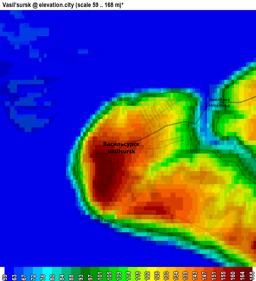
Below is the Elevation map of Vasil’sursk, which displays elevation range with different colors. Scale of the first map is from 59 to 168 m (194 to 551 ft) with average elevation of 86.2 meters (=283 ft) [note 1]
These maps also provides idea of topography and contour of this city, they are displayed at different zoom levels. More info about maps, scale and edge coordinates you can find below images.
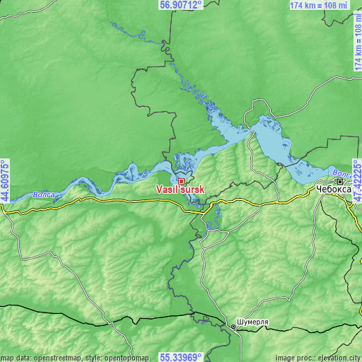
| \ | Map #1 | Topo.Map |
| Scale [m] | 59..168 m | × |
| Scale [ft] | 194..551 ft | × |
| Average | 86.2 m = 283 ft | × |
| Width | 5.45 km = 3.4 mi | 174.3 km = 108.3 mi |
| Height | 5.45 km = 3.4 mi | 174.3 km = 108.3 mi |
| ↑Max Latitude | 56.155872° | 56.90712° |
| Latitude at center | 56.13139° | 56.13139° |
| ↓Min Latitude | 56.106892° | 55.33969° |
| ← Min Longitude | 45.972055° | 44.60975° |
| Longitude center | 46.016° | 46.016° |
| →Max Longitude | 46.059945° | 47.42225° |
Nearby cities:
Cities around Vasil’sursk sort by population:
• Lyskovo elevation 95 m
61.4 km,  259°
259°
• Koz’modem’yansk 109 m
41.1 km,  55°
55°
• Yadrin 77 m
24.3 km,  150°
150°
• Pil’na 85 m
64.5 km,  185°
185°
• Vorotynets 93 m
12.3 km,  230°
230°
• Yurino 65 m
25.4 km,  44°
44°
• Spasskoye 130 m
36.1 km,  213°
213°
• Ishley 164 m
65.3 km,  100°
100°
• Krasnyye Chetai 124 m
49.8 km,  171°
171°
• Morgaushi 154 m
50.6 km,  111°
111°
• Alikovo 171 m
63.5 km,  133°
133°
• Vilovatovo 187 m
36.5 km,  82°
82°
Multilingual:
 En español:
Vasil’sursk elevación 144 m.
 En France:
Vasil’sursk élévation 144 m.
 Auf Deutsch:
Vasil’sursk höhe über dem Meeresspiegel ist 144 m.

Sources and notes:
- [note 1] Map square and city borders are not equal. Map elevation data is calculated only from area inside that square.
- [src 1] Elevation data from geonames database provided with same terms of usage.
- [src 2] The elevation map of Vasil’sursk is generated using elevation data from NASA's 3 arcsec (90m) resolution SRTM data.
- [src 3] Base (background) map © OpenStreetMap contributors tiles are generated by Geofabrik and OpenTopoMap.
Copyright & License:
This Vasil’sursk Elevation Map is licensed under CC BY-SA. You may reuse any part from this page, if you give a proper credit by linking to this URL:
 More info on terms of use page.