Vizinga elevation
Vizinga (Komi), Russia elevation is 108 meters and Vizinga elevation in feet is 354 ft above sea level [src 1]. Vizinga is a populated place (feature code) with elevation that is 91 meters (299 ft) smaller than average city elevation in Russia.
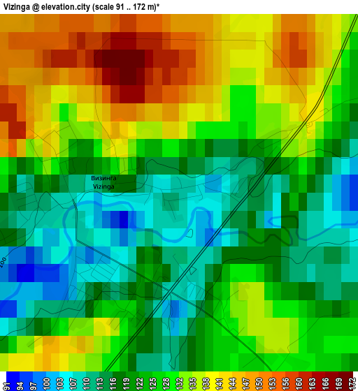
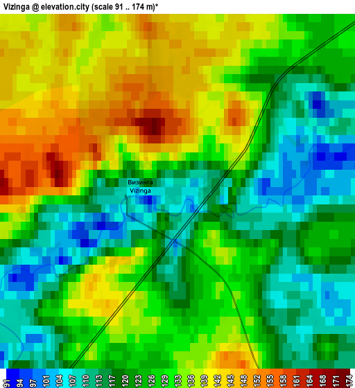
Below is the Elevation map of Vizinga, which displays elevation range with different colors. Scale of the first map is from 91 to 172 m (299 to 564 ft) with average elevation of 127 meters (=417 ft) [note 1]
These maps also provides idea of topography and contour of this city, they are displayed at different zoom levels. More info about maps, scale and edge coordinates you can find below images.
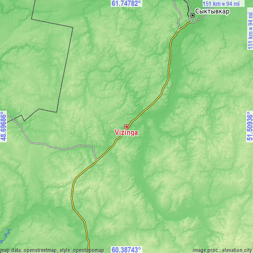
| \ | Map #1 | Map #2 | Topo.Map |
| Scale [m] | 91..172 m | 91..174 m | × |
| Scale [ft] | 299..564 ft | 299..571 ft | × |
| Average | 127 m = 417 ft | 127.3 m = 418 ft | × |
| Width | 4.73 km = 2.9 mi | 9.45 km = 5.9 mi | 151.3 km = 94 mi |
| Height | 4.73 km = 2.9 mi | 9.45 km = 5.9 mi | 151.2 km = 94 mi |
| ↑Max Latitude | 61.096178° | 61.117411° | 61.74782° |
| Latitude at center | 61.07493° | 61.07493° | 61.07493° |
| ↓Min Latitude | 61.053668° | 61.032392° | 60.38743° |
| ← Min Longitude | 50.059165° | 50.015219° | 48.69686° |
| Longitude center | 50.10311° | 50.10311° | 50.10311° |
| →Max Longitude | 50.147055° | 50.191001° | 51.50936° |
Nearby cities:
Cities around Vizinga sort by population:
• Syktyvkar elevation 146 m
75.7 km,  30°
30°
• Ezhva 134 m
88.5 km,  22°
22°
• Zheshart 102 m
114.5 km,  345°
345°
• Urdoma 108 m
112.1 km,  312°
312°
• Kortkeros 87 m
113.4 km,  43°
43°
• Verkhnyaya Maksakovka 109 m
77.5 km, 36°
• Aykino 72 m
128 km,  357°
357°
• Zelenets 106 m
96.4 km, 20°
• Il’insko-Podomskoye 102 m
114.3 km,  272°
272°
• Koygorodok 150 m
85.2 km,  145°
145°
• Sedkyrkeshch 118 m
86.6 km, 29°
• Mordino 134 m
100.8 km,  72°
72°
Multilingual:
 En español:
Vizinga elevación 108 m.
 En France:
Vizinga élévation 108 m.


Sources and notes:
- [note 1] Map square and city borders are not equal. Map elevation data is calculated only from area inside that square.
- [src 1] Elevation data from geonames database provided with same terms of usage.
- [src 2] The elevation map of Vizinga is generated using GMTED2010 database with 7.5 arcsec (225m) resolution.
- [src 3] Base (background) map © OpenStreetMap contributors tiles are generated by Geofabrik and OpenTopoMap.
Copyright & License:
This Vizinga Elevation Map is licensed under CC BY-SA. You may reuse any part from this page, if you give a proper credit by linking to this URL:
 More info on terms of use page.