Zamoskvorech’ye elevation
Zamoskvorech’ye (Moscow), Russia elevation is 128 meters and Zamoskvorech’ye elevation in feet is 420 ft above sea level [src 1]. Zamoskvorech’ye is a section of populated place (feature code) with elevation that is 71 meters (233 ft) smaller than average city elevation in Russia.
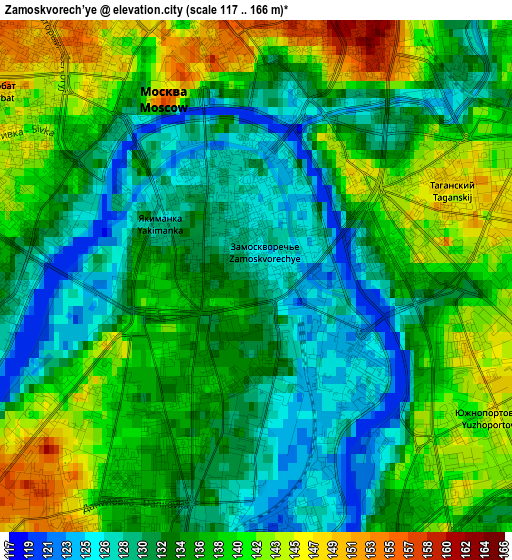
Below is the Elevation map of Zamoskvorech’ye, which displays elevation range with different colors. Scale of the first map is from 117 to 166 m (384 to 545 ft) with average elevation of 135.3 meters (=444 ft) [note 1]
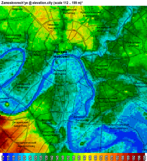
These maps also provides idea of topography and contour of this city, they are displayed at different zoom levels. More info about maps, scale and edge coordinates you can find below images.
| \ | Map #1 | Map #2 | Topo.Map |
| Scale [m] | 117..166 m | 112..199 m | × |
| Scale [ft] | 384..545 ft | 367..653 ft | × |
| Average | 135.3 m = 444 ft | 140.8 m = 462 ft | × |
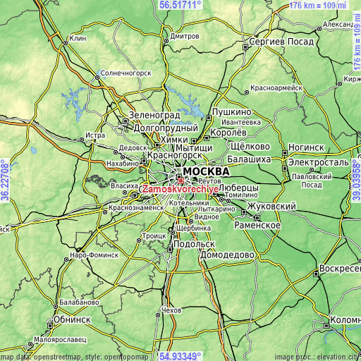
| Width | 5.5 km = 3.4 mi | 11 km = 6.8 mi | 176.1 km = 109.4 mi |
| Height | 5.5 km = 3.4 mi | 11 km = 6.8 mi | 176.1 km = 109.4 mi |
| ↑Max Latitude | 55.758065° | 55.782785° | 56.51711° |
| Latitude at center | 55.73333° | 55.73333° | 55.73333° |
| ↓Min Latitude | 55.708579° | 55.683812° | 54.93349° |
| ← Min Longitude | 37.589385° | 37.545439° | 36.22708° |
| Longitude center | 37.63333° | 37.63333° | 37.63333° |
| →Max Longitude | 37.677275° | 37.721221° | 39.03958° |
Nearby cities:
Cities around Zamoskvorech’ye sort by population:
• Moscow elevation 144 m
2.4 km,  332°
332°
• Presnenskiy 120 m
5.5 km,  289°
289°
• Taganskiy 135 m
2.1 km,  90°
90°
• Novyye Cherëmushki 160 m
4.9 km,  220°
220°
• Tekstil’shchiki 142 m
7.8 km,  118°
118°
• Lefortovo 144 m
5.6 km,  48°
48°
• Dorogomilovo 127 m
4.6 km, 293°
• Semënovskoye 175 m
7.6 km, 223°
• Kozhukhovo 120 m
4.3 km,  150°
150°
• Vorob’yovo 177 m
6.5 km,  253°
253°
• Leninskiye Gory 175 m
5.6 km,  228°
228°
• Luzhniki 161 m
5.3 km, 248°
Multilingual:
 En español:
Zamoskvorech’ye elevación 128 m.
 En France:
Zamoskvorech’ye élévation 128 m.
 Auf Deutsch:
Zamoskvorech’ye höhe über dem Meeresspiegel ist 128 m.

Sources and notes:
- [note 1] Map square and city borders are not equal. Map elevation data is calculated only from area inside that square.
- [src 1] Elevation data from geonames database provided with same terms of usage.
- [src 2] The elevation map of Zamoskvorech’ye is generated using elevation data from NASA's 3 arcsec (90m) resolution SRTM data.
- [src 3] Base (background) map © OpenStreetMap contributors tiles are generated by Geofabrik and OpenTopoMap.
Copyright & License:
This Zamoskvorech’ye Elevation Map is licensed under CC BY-SA. You may reuse any part from this page, if you give a proper credit by linking to this URL:
 More info on terms of use page.