Zavoronezhskoye elevation
Zavoronezhskoye (Tambov), Russia elevation is 125 meters and Zavoronezhskoye elevation in feet is 410 ft above sea level [src 1]. Zavoronezhskoye is a populated place (feature code) with elevation that is 74 meters (243 ft) smaller than average city elevation in Russia.
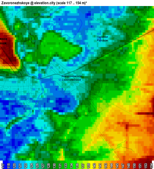
Below is the Elevation map of Zavoronezhskoye, which displays elevation range with different colors. Scale of the first map is from 117 to 154 m (384 to 505 ft) with average elevation of 130.4 meters (=428 ft) [note 1]
These maps also provides idea of topography and contour of this city, they are displayed at different zoom levels. More info about maps, scale and edge coordinates you can find below images.
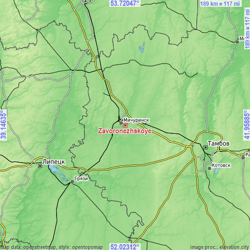
| \ | Map #1 | Map #2 | Topo.Map |
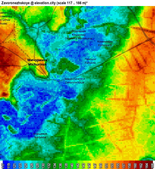
| Scale [m] | 117..154 m | 117..166 m | × |
| Scale [ft] | 384..505 ft | 384..545 ft | × |
| Average | 130.4 m = 428 ft | 136.6 m = 448 ft | × |
| Width | 5.9 km = 3.7 mi | 11.8 km = 7.3 mi | 188.7 km = 117.3 mi |
| Height | 5.9 km = 3.7 mi | 11.8 km = 7.3 mi | 188.7 km = 117.3 mi |
| ↑Max Latitude | 52.906612° | 52.933108° | 53.72047° |
| Latitude at center | 52.8801° | 52.8801° | 52.8801° |
| ↓Min Latitude | 52.853572° | 52.827027° | 52.02312° |
| ← Min Longitude | 40.508655° | 40.464709° | 39.14635° |
| Longitude center | 40.5526° | 40.5526° | 40.5526° |
| →Max Longitude | 40.596545° | 40.640491° | 41.95885° |
Nearby cities:
Cities around Zavoronezhskoye sort by population:
• Tambov elevation 128 m
62.1 km,  105°
105°
• Michurinsk 152 m
4.6 km,  295°
295°
• Gryazi 123 m
59.5 km,  224°
224°
• Chaplygin 148 m
56.4 km,  315°
315°
• Pervomayskiy 158 m
44.6 km,  336°
336°
• Staroyur’yevo 150 m
49.6 km,  12°
12°
• Dobroye 110 m
49.8 km,  268°
268°
• Selezni 140 m
46.9 km,  100°
100°
• Komsomolets 176 m
50.9 km, 104°
• Kalikino 108 m
49.3 km,  278°
278°
• Plekhanovo 128 m
54.5 km,  240°
240°
• Bol’shoy Khomutets 113 m
47 km,  256°
256°
Multilingual:
 En español:
Zavoronezhskoye elevación 125 m.
 En France:
Zavoronezhskoye élévation 125 m.
 Auf Deutsch:
Zavoronezhskoye höhe über dem Meeresspiegel ist 125 m.

Sources and notes:
- [note 1] Map square and city borders are not equal. Map elevation data is calculated only from area inside that square.
- [src 1] Elevation data from geonames database provided with same terms of usage.
- [src 2] The elevation map of Zavoronezhskoye is generated using elevation data from NASA's 3 arcsec (90m) resolution SRTM data.
- [src 3] Base (background) map © OpenStreetMap contributors tiles are generated by Geofabrik and OpenTopoMap.
Copyright & License:
This Zavoronezhskoye Elevation Map is licensed under CC BY-SA. You may reuse any part from this page, if you give a proper credit by linking to this URL:
 More info on terms of use page.