Gryazi elevation
Gryazi (Lipetsk Oblast), Russia elevation is 123 meters and Gryazi elevation in feet is 404 ft above sea level [src 1]. Gryazi is a populated place (feature code) with elevation that is 76 meters (249 ft) smaller than average city elevation in Russia.
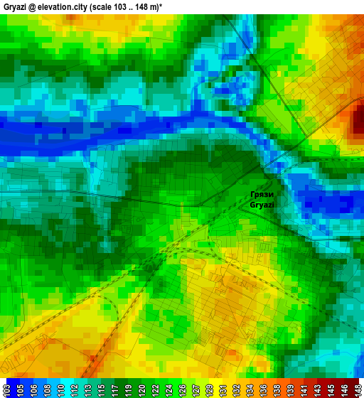
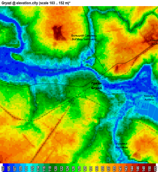
Below is the Elevation map of Gryazi, which displays elevation range with different colors. Scale of the first map is from 103 to 148 m (338 to 486 ft) with average elevation of 120.9 meters (=397 ft) [note 1]
These maps also provides idea of topography and contour of this city, they are displayed at different zoom levels. More info about maps, scale and edge coordinates you can find below images.
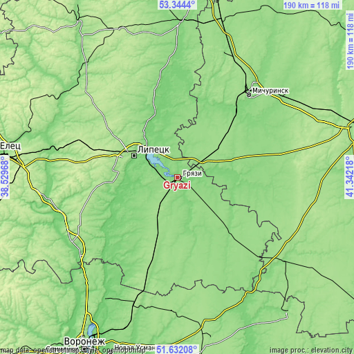
| \ | Map #1 | Map #2 | Topo.Map |
| Scale [m] | 103..148 m | 103..152 m | × |
| Scale [ft] | 338..486 ft | 338..499 ft | × |
| Average | 120.9 m = 397 ft | 124.7 m = 409 ft | × |
| Width | 5.95 km = 3.7 mi | 11.9 km = 7.4 mi | 190.4 km = 118.3 mi |
| Height | 5.95 km = 3.7 mi | 11.9 km = 7.4 mi | 190.4 km = 118.3 mi |
| ↑Max Latitude | 52.523316° | 52.550046° | 53.3444° |
| Latitude at center | 52.49657° | 52.49657° | 52.49657° |
| ↓Min Latitude | 52.469808° | 52.443029° | 51.63208° |
| ← Min Longitude | 39.891985° | 39.848039° | 38.52968° |
| Longitude center | 39.93593° | 39.93593° | 39.93593° |
| →Max Longitude | 39.979875° | 40.023821° | 41.34218° |
Nearby cities:
Cities around Gryazi sort by population:
• Lipetsk elevation 158 m
27.4 km,  295°
295°
• Usman’ 152 m
52 km,  195°
195°
• Dobrinka 155 m
51.9 km,  135°
135°
• Borinskoye 143 m
38.5 km,  263°
263°
• Dobroye 110 m
42.1 km,  348°
348°
• Syrskoye 177 m
30.9 km,  286°
286°
• Kalikino 108 m
50.9 km, 351°
• Prigorodka 154 m
52.5 km, 196°
• Kazinka 114 m
9 km, 300°
• Plekhanovo 128 m
16.9 km,  339°
339°
• Kuz’minskiye Otverzhki 169 m
38.5 km,  305°
305°
• Bol’shoy Khomutets 113 m
32.1 km, 352°
Multilingual:
 En español:
Gryazi elevación 123 m.
 En France:
Gryazi élévation 123 m.


Sources and notes:
- [note 1] Map square and city borders are not equal. Map elevation data is calculated only from area inside that square.
- [src 1] Elevation data from geonames database provided with same terms of usage.
- [src 2] The elevation map of Gryazi is generated using elevation data from NASA's 3 arcsec (90m) resolution SRTM data.
- [src 3] Base (background) map © OpenStreetMap contributors tiles are generated by Geofabrik and OpenTopoMap.
Copyright & License:
This Gryazi Elevation Map is licensed under CC BY-SA. You may reuse any part from this page, if you give a proper credit by linking to this URL:
 More info on terms of use page.