Khandyga elevation
Khandyga (Sakha, Tomponskiy District), Russia elevation is 125 meters and Khandyga elevation in feet is 410 ft above sea level [src 1]. Khandyga is a populated place (feature code) with elevation that is 74 meters (243 ft) smaller than average city elevation in Russia.
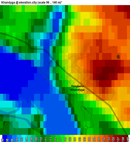
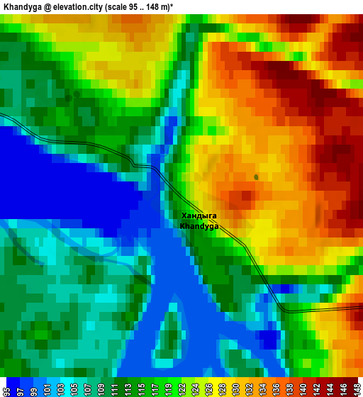
Below is the Elevation map of Khandyga, which displays elevation range with different colors. Scale of the first map is from 96 to 140 m (315 to 459 ft) with average elevation of 114.9 meters (=377 ft) [note 1]
These maps also provides idea of topography and contour of this city, they are displayed at different zoom levels. More info about maps, scale and edge coordinates you can find below images.
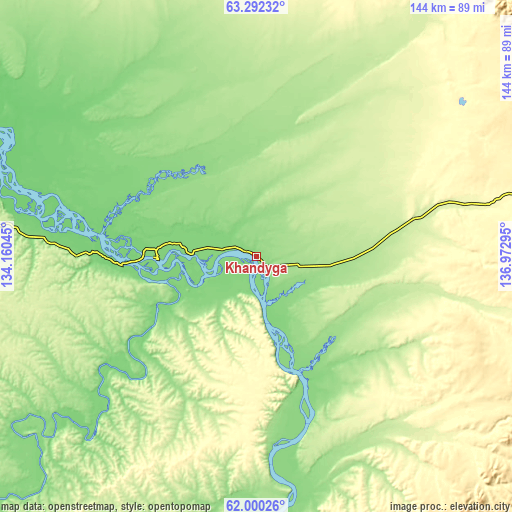
| \ | Map #1 | Map #2 | Topo.Map |
| Scale [m] | 96..140 m | 95..148 m | × |
| Scale [ft] | 315..459 ft | 312..486 ft | × |
| Average | 114.9 m = 377 ft | 117.8 m = 386 ft | × |
| Width | 4.49 km = 2.8 mi | 8.98 km = 5.6 mi | 143.7 km = 89.3 mi |
| Height | 4.49 km = 2.8 mi | 8.98 km = 5.6 mi | 143.6 km = 89.2 mi |
| ↑Max Latitude | 62.67351° | 62.693677° | 63.29232° |
| Latitude at center | 62.65333° | 62.65333° | 62.65333° |
| ↓Min Latitude | 62.633136° | 62.612928° | 62.00026° |
| ← Min Longitude | 135.522755° | 135.478809° | 134.16045° |
| Longitude center | 135.5667° | 135.5667° | 135.5667° |
| →Max Longitude | 135.610645° | 135.654591° | 136.97295° |
Nearby cities:
Cities around Khandyga sort by population:
• Churapcha elevation 166 m
177.4 km,  245°
245°
• Ytyk-Kyuyël’ 169 m
108 km, 252°
• Amga 159 m
271.2 km,  224°
224°
• Nezhdaninskoe 608 m
179.2 km,  95°
95°
• Ust-Maya 170 m
254.6 km,  192°
192°
• Dzhebariki-Khaya 114 m
51.3 km,  163°
163°
• Solnechnyy 493 m
281.9 km, 158°
Multilingual:
 En español:
Khandyga elevación 125 m.
 En France:
Khandyga élévation 125 m.
 Auf Deutsch:
Khandyga höhe über dem Meeresspiegel ist 125 m.

Sources and notes:
- [note 1] Map square and city borders are not equal. Map elevation data is calculated only from area inside that square.
- [src 1] Elevation data from geonames database provided with same terms of usage.
- [src 2] The elevation map of Khandyga is generated using GMTED2010 database with 7.5 arcsec (225m) resolution.
- [src 3] Base (background) map © OpenStreetMap contributors tiles are generated by Geofabrik and OpenTopoMap.
Copyright & License:
This Khandyga Elevation Map is licensed under CC BY-SA. You may reuse any part from this page, if you give a proper credit by linking to this URL:
 More info on terms of use page.