Ytyk-Kyuyël’ elevation
Ytyk-Kyuyël’ (Sakha), Russia elevation is 169 meters and Ytyk-Kyuyël’ elevation in feet is 554 ft above sea level [src 1]. Ytyk-Kyuyël’ is a populated place (feature code) with elevation that is 30 meters (98 ft) smaller than average city elevation in Russia.
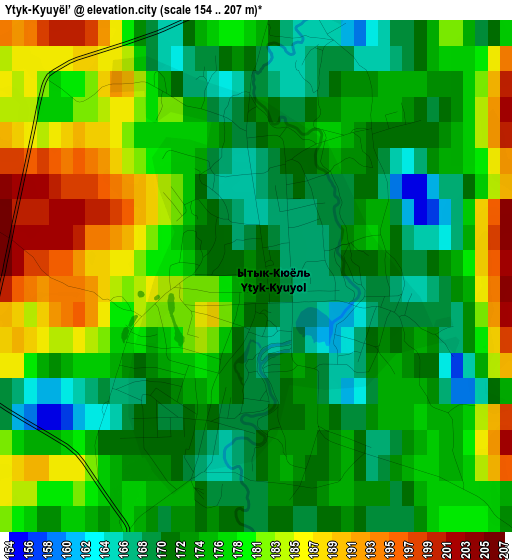
Below is the Elevation map of Ytyk-Kyuyël’, which displays elevation range with different colors. Scale of the first map is from 154 to 207 m (505 to 679 ft) with average elevation of 176.5 meters (=579 ft) [note 1]
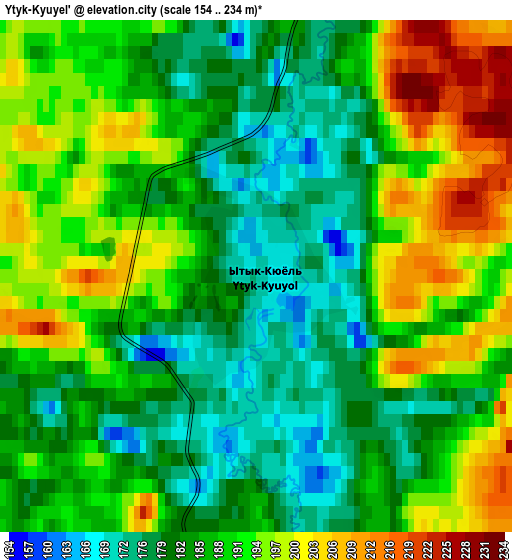
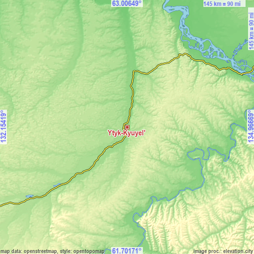
These maps also provides idea of topography and contour of this city, they are displayed at different zoom levels. More info about maps, scale and edge coordinates you can find below images.
| \ | Map #1 | Map #2 | Topo.Map |
| Scale [m] | 154..207 m | 154..234 m | × |
| Scale [ft] | 505..679 ft | 505..768 ft | × |
| Average | 176.5 m = 579 ft | 187.8 m = 616 ft | × |
| Width | 4.53 km = 2.8 mi | 9.07 km = 5.6 mi | 145.1 km = 90.2 mi |
| Height | 4.53 km = 2.8 mi | 9.07 km = 5.6 mi | 145.1 km = 90.2 mi |
| ↑Max Latitude | 62.381569° | 62.401934° | 63.00649° |
| Latitude at center | 62.36119° | 62.36119° | 62.36119° |
| ↓Min Latitude | 62.340797° | 62.32039° | 61.70171° |
| ← Min Longitude | 133.516495° | 133.472549° | 132.15419° |
| Longitude center | 133.56044° | 133.56044° | 133.56044° |
| →Max Longitude | 133.604385° | 133.648331° | 134.96669° |
Nearby cities:
Cities around Ytyk-Kyuyël’ sort by population:
• Yakutsk elevation 126 m
201.8 km,  259°
259°
• Markha 99 m
199.5 km, 262°
• Zhatay 102 m
194.4 km, 263°
• Namtsy 76 m
203.5 km,  281°
281°
• Churapcha 166 m
71 km,  235°
235°
• Khandyga 125 m
108 km,  72°
72°
• Mayya 148 m
184.4 km,  247°
247°
• Amga 159 m
182.7 km,  207°
207°
• Borogontsy 124 m
127.7 km,  285°
285°
• Nizhniy Bestyakh 136 m
194.5 km, 256°
• Dzhebariki-Khaya 114 m
119.5 km,  98°
98°
• Kangalassy 85 m
185.5 km,  269°
269°
Multilingual:
 En español:
Ytyk-Kyuyël’ elevación 169 m.
 En France:
Ytyk-Kyuyël’ élévation 169 m.
 Auf Deutsch:
Ytyk-Kyuyël’ höhe über dem Meeresspiegel ist 169 m.

Sources and notes:
- [note 1] Map square and city borders are not equal. Map elevation data is calculated only from area inside that square.
- [src 1] Elevation data from geonames database provided with same terms of usage.
- [src 2] The elevation map of Ytyk-Kyuyël’ is generated using GMTED2010 database with 7.5 arcsec (225m) resolution.
- [src 3] Base (background) map © OpenStreetMap contributors tiles are generated by Geofabrik and OpenTopoMap.
Copyright & License:
This Ytyk-Kyuyël’ Elevation Map is licensed under CC BY-SA. You may reuse any part from this page, if you give a proper credit by linking to this URL:
 More info on terms of use page.