Kholtoson elevation
Kholtoson (Buryatiya Republic), Russia elevation is 1220 meters and Kholtoson elevation in feet is 4003 ft above sea level [src 1]. Kholtoson is a populated place (feature code) with elevation that is 1021 meters (3350 ft) bigger than average city elevation in Russia.
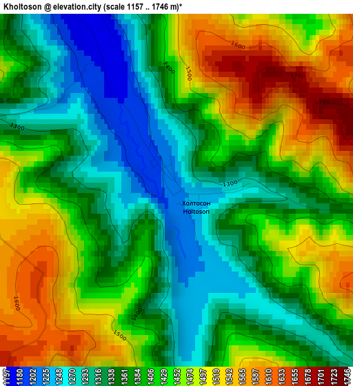
Below is the Elevation map of Kholtoson, which displays elevation range with different colors. Scale of the first map is from 1157 to 1746 m (3796 to 5728 ft) with average elevation of 1406.6 meters (=4615 ft) [note 1]
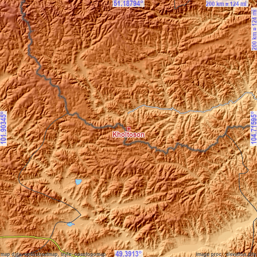
These maps also provides idea of topography and contour of this city, they are displayed at different zoom levels. More info about maps, scale and edge coordinates you can find below images.
| \ | Map #1 | Topo.Map |
| Scale [m] | 1157..1746 m | × |
| Scale [ft] | 3796..5728 ft | × |
| Average | 1406.6 m = 4615 ft | × |
| Width | 6.24 km = 3.9 mi | 199.8 km = 124.1 mi |
| Height | 6.24 km = 3.9 mi | 199.8 km = 124.1 mi |
| ↑Max Latitude | 50.326164° | 51.18794° |
| Latitude at center | 50.2981° | 50.2981° |
| ↓Min Latitude | 50.27002° | 49.3913° |
| ← Min Longitude | 103.265755° | 101.90345° |
| Longitude center | 103.3097° | 103.3097° |
| →Max Longitude | 103.353645° | 104.71595° |
Nearby cities:
Cities around Kholtoson sort by population:
• Slyudyanka elevation 477 m
153.9 km,  10°
10°
• Baykal’sk 495 m
147.3 km,  23°
23°
• Zakamensk 1095 m
8.6 km,  348°
348°
• Petropavlovka 687 m
146.5 km,  76°
76°
• Kyren 751 m
174.3 km,  332°
332°
• Vydrino 469 m
159.7 km,  35°
35°
• Rechka-Vydrino 459 m
170.6 km, 39°
• Kultuk 463 m
160.5 km, 9°
• Naushki 596 m
198.6 km,  87°
87°
• Zhemchug 729 m
165.4 km,  338°
338°
• Bayangol 1238 m
45.8 km, 13°
• Tankhoy 471 m
189.2 km, 42°
Multilingual:
 En español:
Kholtoson elevación 1220 m.
 En France:
Kholtoson élévation 1220 m.
 Auf Deutsch:
Kholtoson höhe über dem Meeresspiegel ist 1220 m.

Sources and notes:
- [note 1] Map square and city borders are not equal. Map elevation data is calculated only from area inside that square.
- [src 1] Elevation data from geonames database provided with same terms of usage.
- [src 2] The elevation map of Kholtoson is generated using elevation data from NASA's 3 arcsec (90m) resolution SRTM data.
- [src 3] Base (background) map © OpenStreetMap contributors tiles are generated by Geofabrik and OpenTopoMap.
Copyright & License:
This Kholtoson Elevation Map is licensed under CC BY-SA. You may reuse any part from this page, if you give a proper credit by linking to this URL:
 More info on terms of use page.