Rechka-Vydrino elevation
Rechka-Vydrino (Buryatiya Republic), Russia elevation is 459 meters and Rechka-Vydrino elevation in feet is 1506 ft above sea level [src 1]. Rechka-Vydrino is a populated place (feature code) with elevation that is 260 meters (853 ft) bigger than average city elevation in Russia.
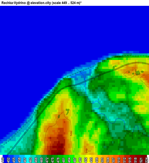
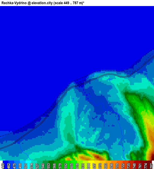
Below is the Elevation map of Rechka-Vydrino, which displays elevation range with different colors. Scale of the first map is from 449 to 524 m (1473 to 1719 ft) with average elevation of 464.9 meters (=1525 ft) [note 1]
These maps also provides idea of topography and contour of this city, they are displayed at different zoom levels. More info about maps, scale and edge coordinates you can find below images.
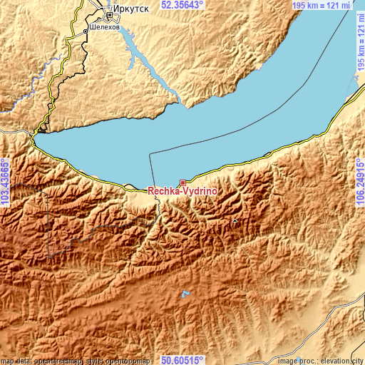
| \ | Map #1 | Map #2 | Topo.Map |
| Scale [m] | 449..524 m | 449..787 m | × |
| Scale [ft] | 1473..1719 ft | 1473..2582 ft | × |
| Average | 464.9 m = 1525 ft | 476.3 m = 1563 ft | × |
| Width | 6.08 km = 3.8 mi | 12.17 km = 7.6 mi | 194.7 km = 121 mi |
| Height | 6.08 km = 3.8 mi | 12.17 km = 7.6 mi | 194.7 km = 121 mi |
| ↑Max Latitude | 51.516555° | 51.543893° | 52.35643° |
| Latitude at center | 51.4892° | 51.4892° | 51.4892° |
| ↓Min Latitude | 51.461829° | 51.434441° | 50.60515° |
| ← Min Longitude | 104.798955° | 104.755009° | 103.43665° |
| Longitude center | 104.8429° | 104.8429° | 104.8429° |
| →Max Longitude | 104.886845° | 104.930791° | 106.24915° |
Nearby cities:
Cities around Rechka-Vydrino sort by population:
• Slyudyanka elevation 477 m
80.8 km,  283°
283°
• Markova 456 m
91 km,  331°
331°
• Baykal’sk 495 m
48.7 km,  273°
273°
• Vydrino 469 m
14.2 km,  258°
258°
• Babushkin 471 m
74.8 km,  70°
70°
• Kultuk 463 m
83.3 km,  288°
288°
• Pivovarikha 479 m
91.1 km,  342°
342°
• Bol’shaya Rechka 499 m
52.2 km,  351°
351°
• Listvyanka 554 m
40.5 km,  2°
2°
• Pad’ Mel’nichnaya 461 m
81.1 km, 336°
• Dzerzhinsk 465 m
93.4 km, 340°
• Tankhoy 471 m
21 km, 69°
Multilingual:
 En español:
Rechka-Vydrino elevación 459 m.
 En France:
Rechka-Vydrino élévation 459 m.
 Auf Deutsch:
Rechka-Vydrino höhe über dem Meeresspiegel ist 459 m.
 На русском:
Выдрино, Речка-Выдрино высота над уровнем моря 459 м
Sources and notes:
- [note 1] Map square and city borders are not equal. Map elevation data is calculated only from area inside that square.
- [src 1] Elevation data from geonames database provided with same terms of usage.
- [src 2] The elevation map of Rechka-Vydrino is generated using elevation data from NASA's 3 arcsec (90m) resolution SRTM data.
- [src 3] Base (background) map © OpenStreetMap contributors tiles are generated by Geofabrik and OpenTopoMap.
Copyright & License:
This Rechka-Vydrino Elevation Map is licensed under CC BY-SA. You may reuse any part from this page, if you give a proper credit by linking to this URL:
 More info on terms of use page.