Seryshevo elevation
Seryshevo (Amur Oblast), Russia elevation is 174 meters and Seryshevo elevation in feet is 571 ft above sea level [src 1]. Seryshevo is a populated place (feature code) with elevation that is 25 meters (82 ft) smaller than average city elevation in Russia.
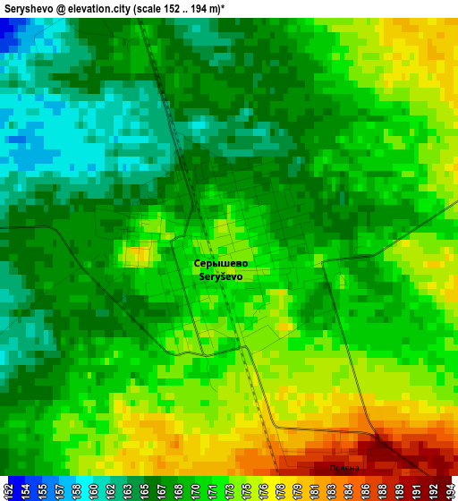
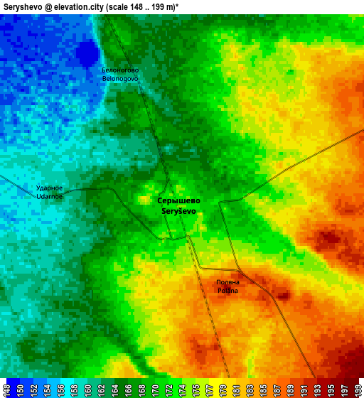
Below is the Elevation map of Seryshevo, which displays elevation range with different colors. Scale of the first map is from 152 to 194 m (499 to 636 ft) with average elevation of 170.1 meters (=558 ft) [note 1]
These maps also provides idea of topography and contour of this city, they are displayed at different zoom levels. More info about maps, scale and edge coordinates you can find below images.
| \ | Map #1 | Map #2 | Topo.Map |
| Scale [m] | 152..194 m | 148..199 m | × |
| Scale [ft] | 499..636 ft | 486..653 ft | × |
| Average | 170.1 m = 558 ft | 170.8 m = 560 ft | × |
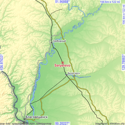
| Width | 6.14 km = 3.8 mi | 12.28 km = 7.6 mi | 196.4 km = 122 mi |
| Height | 6.14 km = 3.8 mi | 12.28 km = 7.6 mi | 196.4 km = 122 mi |
| ↑Max Latitude | 51.121501° | 51.149076° | 51.96868° |
| Latitude at center | 51.09391° | 51.09391° | 51.09391° |
| ↓Min Latitude | 51.066302° | 51.038678° | 50.20227° |
| ← Min Longitude | 128.338635° | 128.294689° | 126.97633° |
| Longitude center | 128.38258° | 128.38258° | 128.38258° |
| →Max Longitude | 128.426525° | 128.470471° | 129.78883° |
Nearby cities:
Cities around Seryshevo sort by population:
• Blagoveshchensk elevation 131 m
108.2 km,  213°
213°
• Belogorsk 169 m
20.8 km,  161°
161°
• Svobodnyy 181 m
35.5 km,  331°
331°
• Raychikhinsk 190 m
162.2 km,  153°
153°
• Shimanovsk 267 m
112.5 km, 334°
• Zavitinsk 237 m
132.4 km, 145°
• Yekaterinoslavka 236 m
95.1 km, 147°
• Tambovka 174 m
112.9 km,  191°
191°
• Tsiolkovskiy 238 m
77.1 km,  346°
346°
• Talakan 269 m
161.7 km,  124°
124°
• Srednebelaya 154 m
55 km, 208°
• Romny 232 m
76 km, 123°
Multilingual:
 En español:
Seryshevo elevación 174 m.
 En France:
Seryshevo élévation 174 m.
 Auf Deutsch:
Seryshevo höhe über dem Meeresspiegel ist 174 m.

Sources and notes:
- [note 1] Map square and city borders are not equal. Map elevation data is calculated only from area inside that square.
- [src 1] Elevation data from geonames database provided with same terms of usage.
- [src 2] The elevation map of Seryshevo is generated using elevation data from NASA's 3 arcsec (90m) resolution SRTM data.
- [src 3] Base (background) map © OpenStreetMap contributors tiles are generated by Geofabrik and OpenTopoMap.
Copyright & License:
This Seryshevo Elevation Map is licensed under CC BY-SA. You may reuse any part from this page, if you give a proper credit by linking to this URL:
 More info on terms of use page.