Zarechnyy elevation
Zarechnyy (Buryatiya Republic), Russia elevation is 497 meters and Zarechnyy elevation in feet is 1631 ft above sea level [src 1]. Zarechnyy is a section of populated place (feature code) with elevation that is 298 meters (978 ft) bigger than average city elevation in Russia.
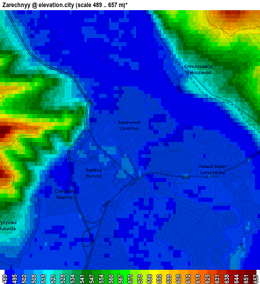
Below is the Elevation map of Zarechnyy, which displays elevation range with different colors. Scale of the first map is from 489 to 657 m (1604 to 2156 ft) with average elevation of 513 meters (=1683 ft) [note 1]
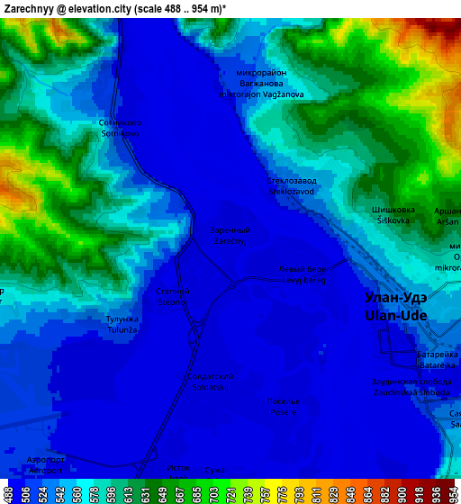
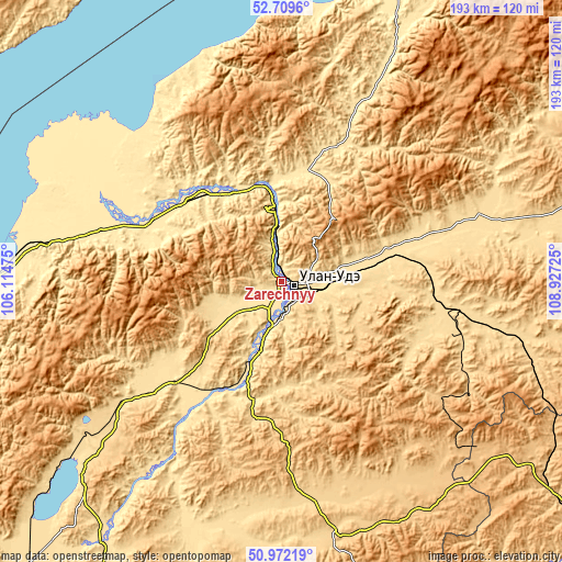
These maps also provides idea of topography and contour of this city, they are displayed at different zoom levels. More info about maps, scale and edge coordinates you can find below images.
| \ | Map #1 | Map #2 | Topo.Map |
| Scale [m] | 489..657 m | 488..954 m | × |
| Scale [ft] | 1604..2156 ft | 1601..3130 ft | × |
| Average | 513 m = 1683 ft | 558.4 m = 1832 ft | × |
| Width | 6.04 km = 3.8 mi | 12.07 km = 7.5 mi | 193.2 km = 120 mi |
| Height | 6.04 km = 3.8 mi | 12.07 km = 7.5 mi | 193.2 km = 120 mi |
| ↑Max Latitude | 51.876418° | 51.90354° | 52.7096° |
| Latitude at center | 51.84928° | 51.84928° | 51.84928° |
| ↓Min Latitude | 51.822125° | 51.794954° | 50.97219° |
| ← Min Longitude | 107.477055° | 107.433109° | 106.11475° |
| Longitude center | 107.521° | 107.521° | 107.521° |
| →Max Longitude | 107.564945° | 107.608891° | 108.92725° |
Nearby cities:
Cities around Zarechnyy sort by population:
• Ulan-Ude elevation 528 m
6.4 km,  112°
112°
• Onokhoy 534 m
38.5 km,  76°
76°
• Ivolginsk 544 m
19.7 km,  235°
235°
• Turuntayevo 518 m
40.1 km,  12°
12°
• Sokol 508 m
7.6 km,  224°
224°
• Sotnikovo 499 m
4.7 km,  325°
325°
• Il’inka 487 m
34.6 km, 330°
• Tarbagatay 550 m
42.3 km,  195°
195°
• Tataurovo 489 m
33 km,  350°
350°
• Nizhniy Sayantuy 503 m
12.4 km,  182°
182°
• Nikolayevskiy 687 m
28.9 km,  138°
138°
• Bol’shoy Kunaley 659 m
46.8 km,  172°
172°
Multilingual:
 En español:
Zarechnyy elevación 497 m.
 En France:
Zarechnyy élévation 497 m.
 Auf Deutsch:
Zarechnyy höhe über dem Meeresspiegel ist 497 m.

Sources and notes:
- [note 1] Map square and city borders are not equal. Map elevation data is calculated only from area inside that square.
- [src 1] Elevation data from geonames database provided with same terms of usage.
- [src 2] The elevation map of Zarechnyy is generated using elevation data from NASA's 3 arcsec (90m) resolution SRTM data.
- [src 3] Base (background) map © OpenStreetMap contributors tiles are generated by Geofabrik and OpenTopoMap.
Copyright & License:
This Zarechnyy Elevation Map is licensed under CC BY-SA. You may reuse any part from this page, if you give a proper credit by linking to this URL:
 More info on terms of use page.