Beška elevation
Beška (Vojvodina, Srem), Serbia elevation is 120 meters and Beška elevation in feet is 394 ft above sea level [src 1]. Beška is a populated place (feature code) with elevation that is 47 meters (154 ft) smaller than average city elevation in Serbia.
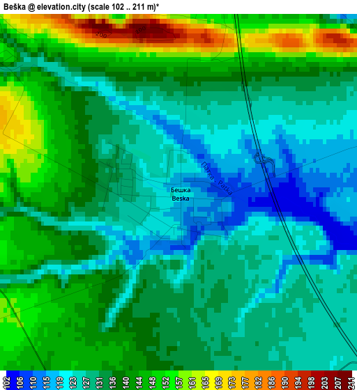
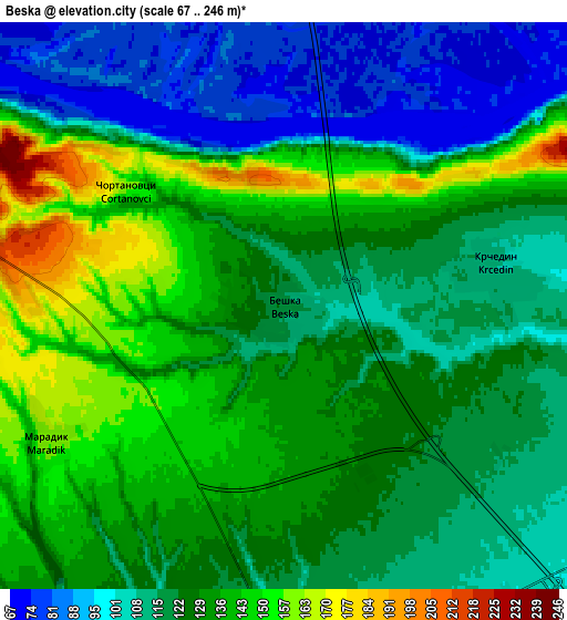
Below is the Elevation map of Beška, which displays elevation range with different colors. Scale of the first map is from 102 to 211 m (335 to 692 ft) with average elevation of 135.4 meters (=444 ft) [note 1]
These maps also provides idea of topography and contour of this city, they are displayed at different zoom levels. More info about maps, scale and edge coordinates you can find below images.
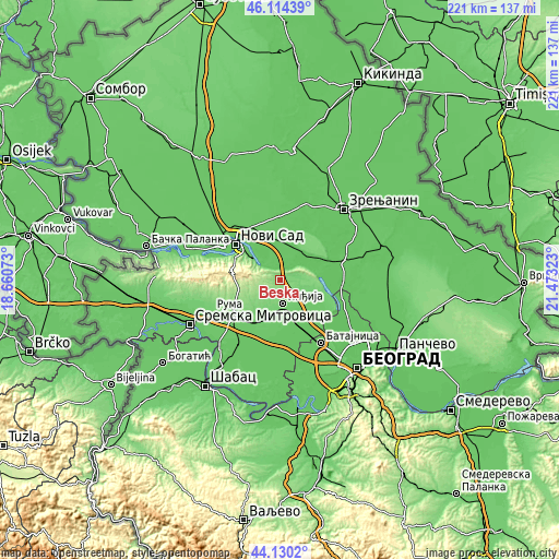
| \ | Map #1 | Map #2 | Topo.Map |
| Scale [m] | 102..211 m | 67..246 m | × |
| Scale [ft] | 335..692 ft | 220..807 ft | × |
| Average | 135.4 m = 444 ft | 124.4 m = 408 ft | × |
| Width | 6.89 km = 4.3 mi | 13.79 km = 8.6 mi | 220.6 km = 137.1 mi |
| Height | 6.89 km = 4.3 mi | 13.79 km = 8.6 mi | 220.6 km = 137.1 mi |
| ↑Max Latitude | 45.161915° | 45.192892° | 46.11439° |
| Latitude at center | 45.13092° | 45.13092° | 45.13092° |
| ↓Min Latitude | 45.099909° | 45.06888° | 44.1302° |
| ← Min Longitude | 20.023035° | 19.979089° | 18.66073° |
| Longitude center | 20.06698° | 20.06698° | 20.06698° |
| →Max Longitude | 20.110925° | 20.154871° | 21.47323° |
Nearby cities:
Cities around Beška sort by population:
• Inđija elevation 114 m
9.3 km,  172°
172°
• Sremski Karlovci 64 m
13.2 km,  307°
307°
• Kovilj 78 m
12 km,  343°
343°
• Šajkaš 78 m
15.9 km,  6°
6°
• Novi Slankamen 127 m
13.5 km,  92°
92°
• Novi Karlovci 100 m
10.7 km,  124°
124°
• Krčedin 108 m
5.3 km,  80°
80°
• Čortanovci 156 m
4.6 km,  304°
304°
• Gardinovci 77 m
9.7 km,  33°
33°
• Lok 74 m
14.8 km,  50°
50°
• Ljukovo 105 m
12.1 km,  194°
194°
• Vilovo 74 m
14.8 km, 27°
Multilingual:
 En español:
Beška elevación 120 m.
 En France:
Beška élévation 120 m.


Sources and notes:
- [note 1] Map square and city borders are not equal. Map elevation data is calculated only from area inside that square.
- [src 1] Elevation data from geonames database provided with same terms of usage.
- [src 2] The elevation map of Beška is generated using elevation data from NASA's 3 arcsec (90m) resolution SRTM data.
- [src 3] Base (background) map © OpenStreetMap contributors tiles are generated by Geofabrik and OpenTopoMap.
Copyright & License:
This Beška Elevation Map is licensed under CC BY-SA. You may reuse any part from this page, if you give a proper credit by linking to this URL:
 More info on terms of use page.