Jaša Tomić elevation
Jaša Tomić (Vojvodina, Central Banat), Serbia elevation is 75 meters and Jaša Tomić elevation in feet is 246 ft above sea level [src 1]. Jaša Tomić is a populated place (feature code) with elevation that is 92 meters (302 ft) smaller than average city elevation in Serbia.
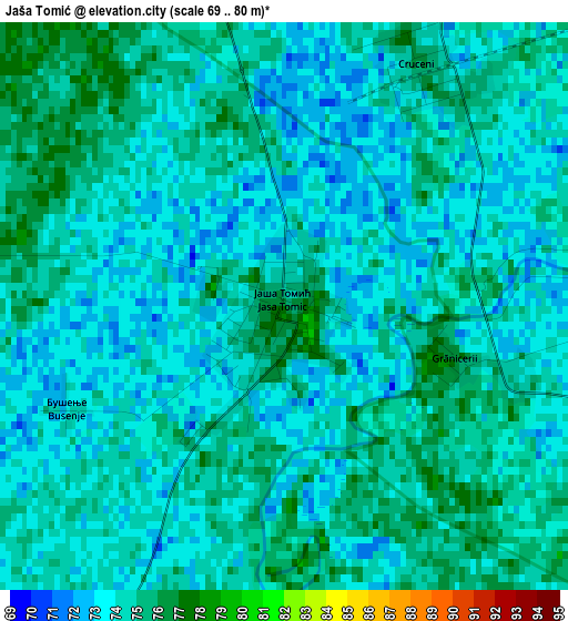
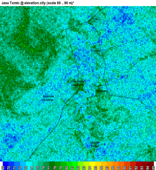
Below is the Elevation map of Jaša Tomić, which displays elevation range with different colors. Scale of the first map is from 69 to 80 m (226 to 262 ft) with average elevation of 73.8 meters (=242 ft) [note 1]
These maps also provides idea of topography and contour of this city, they are displayed at different zoom levels. More info about maps, scale and edge coordinates you can find below images.
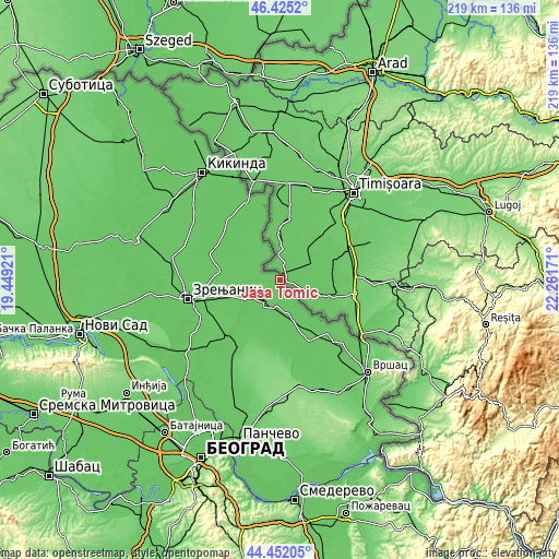
| \ | Map #1 | Map #2 | Topo.Map |
| Scale [m] | 69..80 m | 69..80 m | × |
| Scale [ft] | 226..262 ft | 226..262 ft | × |
| Average | 73.8 m = 242 ft | 73.9 m = 242 ft | × |
| Width | 6.86 km = 4.3 mi | 13.71 km = 8.5 mi | 219.4 km = 136.3 mi |
| Height | 6.86 km = 4.3 mi | 13.71 km = 8.5 mi | 219.4 km = 136.3 mi |
| ↑Max Latitude | 45.478072° | 45.508877° | 46.4252° |
| Latitude at center | 45.44725° | 45.44725° | 45.44725° |
| ↓Min Latitude | 45.416411° | 45.385555° | 44.45205° |
| ← Min Longitude | 20.811515° | 20.767569° | 19.44921° |
| Longitude center | 20.85546° | 20.85546° | 20.85546° |
| →Max Longitude | 20.899405° | 20.943351° | 22.26171° |
Nearby cities:
Cities around Jaša Tomić sort by population:
• Torak elevation 78 m
20.4 km,  289°
289°
• Srpski Itebej 78 m
17.3 km,  320°
320°
• Sečanj 77 m
11.1 km,  215°
215°
• Krajišnik 79 m
9.8 km,  273°
273°
• Boka 75 m
10.4 km,  191°
191°
• Sutjeska 75 m
14.3 km,  240°
240°
• Banatski Despotovac 75 m
17.5 km, 238°
• Neuzina 74 m
15.9 km, 224°
• Međa 77 m
10.8 km,  339°
339°
• Novi Itebej 75 m
17.4 km, 315°
• Stari Lec 73 m
20 km,  154°
154°
• Konak 74 m
15.3 km,  162°
162°
Multilingual:
 En español:
Jaša Tomić elevación 75 m.
 En France:
Jaša Tomić élévation 75 m.
 Auf Deutsch:
Jaša Tomić höhe über dem Meeresspiegel ist 75 m.

Sources and notes:
- [note 1] Map square and city borders are not equal. Map elevation data is calculated only from area inside that square.
- [src 1] Elevation data from geonames database provided with same terms of usage.
- [src 2] The elevation map of Jaša Tomić is generated using elevation data from NASA's 3 arcsec (90m) resolution SRTM data.
- [src 3] Base (background) map © OpenStreetMap contributors tiles are generated by Geofabrik and OpenTopoMap.
Copyright & License:
This Jaša Tomić Elevation Map is licensed under CC BY-SA. You may reuse any part from this page, if you give a proper credit by linking to this URL:
 More info on terms of use page.