Kovin elevation
Kovin (Vojvodina, South Banat), Serbia elevation is 78 meters and Kovin elevation in feet is 256 ft above sea level [src 1]. Kovin is a seat of a third-order administrative division (feature code) with elevation that is 89 meters (292 ft) smaller than average city elevation in Serbia.
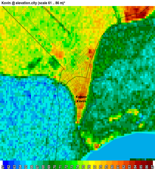
Below is the Elevation map of Kovin, which displays elevation range with different colors. Scale of the first map is from 61 to 86 m (200 to 282 ft) with average elevation of 69.8 meters (=229 ft) [note 1]
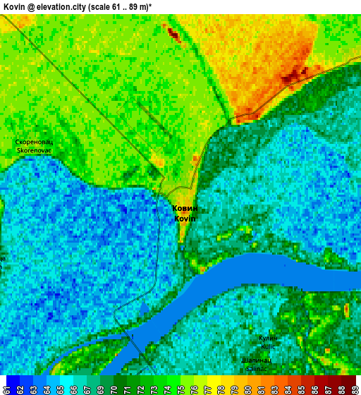
These maps also provides idea of topography and contour of this city, they are displayed at different zoom levels. More info about maps, scale and edge coordinates you can find below images.
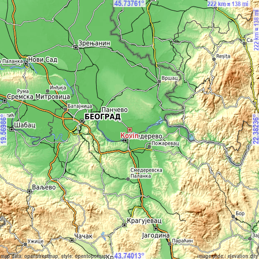
| \ | Map #1 | Map #2 | Topo.Map |
| Scale [m] | 61..86 m | 61..89 m | × |
| Scale [ft] | 200..282 ft | 200..292 ft | × |
| Average | 69.8 m = 229 ft | 70.3 m = 231 ft | × |
| Width | 6.94 km = 4.3 mi | 13.88 km = 8.6 mi | 222.1 km = 138 mi |
| Height | 6.94 km = 4.3 mi | 13.88 km = 8.6 mi | 222.1 km = 138 mi |
| ↑Max Latitude | 44.778702° | 44.809888° | 45.73761° |
| Latitude at center | 44.7475° | 44.7475° | 44.7475° |
| ↓Min Latitude | 44.716281° | 44.685045° | 43.74013° |
| ← Min Longitude | 20.932165° | 20.888219° | 19.56986° |
| Longitude center | 20.97611° | 20.97611° | 20.97611° |
| →Max Longitude | 21.020055° | 21.064001° | 22.38236° |
Nearby cities:
Cities around Kovin sort by population:
• Pančevo elevation 80 m
29.8 km,  297°
297°
• Smederevo 79 m
10 km,  202°
202°
• Požarevac 80 m
21.8 km,  129°
129°
• Banatski Karlovac 97 m
33.8 km,  5°
5°
• Vladimirovac 137 m
32.7 km,  344°
344°
• Uljma 87 m
35.6 km,  23°
23°
• Lugavčina 82 m
26 km,  163°
163°
• Izbište 95 m
34.7 km,  28°
28°
• Nikolinci 87 m
34.7 km, 11°
• Zvezdara 221 m
35.2 km,  274°
274°
• Malo Crniće 85 m
32.4 km, 131°
• Grocka 85 m
22.2 km,  247°
247°
Multilingual:
 En español:
Kovin elevación 78 m.
 En France:
Kovin élévation 78 m.


Sources and notes:
- [note 1] Map square and city borders are not equal. Map elevation data is calculated only from area inside that square.
- [src 1] Elevation data from geonames database provided with same terms of usage.
- [src 2] The elevation map of Kovin is generated using elevation data from NASA's 3 arcsec (90m) resolution SRTM data.
- [src 3] Base (background) map © OpenStreetMap contributors tiles are generated by Geofabrik and OpenTopoMap.
Copyright & License:
This Kovin Elevation Map is licensed under CC BY-SA. You may reuse any part from this page, if you give a proper credit by linking to this URL:
 More info on terms of use page.