Majdanpek elevation
Majdanpek (Central Serbia, Bor), Serbia elevation is 504 meters and Majdanpek elevation in feet is 1654 ft above sea level [src 1]. Majdanpek is a seat of a third-order administrative division (feature code) with elevation that is 337 meters (1106 ft) bigger than average city elevation in Serbia.
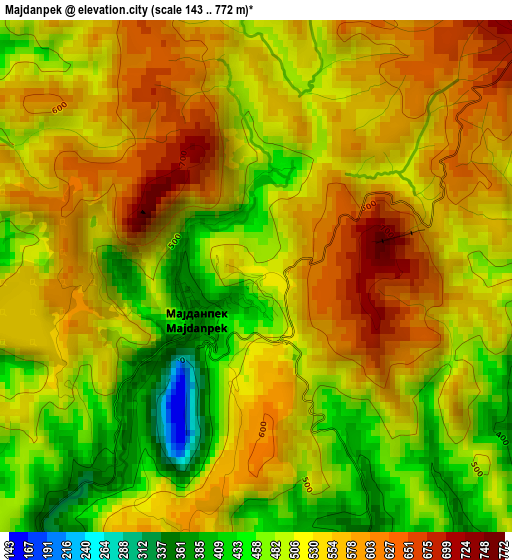
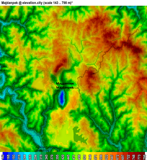
Below is the Elevation map of Majdanpek, which displays elevation range with different colors. Scale of the first map is from 143 to 772 m (469 to 2533 ft) with average elevation of 529.3 meters (=1737 ft) [note 1]
These maps also provides idea of topography and contour of this city, they are displayed at different zoom levels. More info about maps, scale and edge coordinates you can find below images.
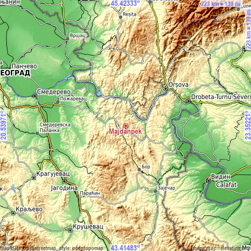
| \ | Map #1 | Map #2 | Topo.Map |
| Scale [m] | 143..772 m | 143..798 m | × |
| Scale [ft] | 469..2533 ft | 469..2618 ft | × |
| Average | 529.3 m = 1737 ft | 502.1 m = 1647 ft | × |
| Width | 6.98 km = 4.3 mi | 13.96 km = 8.7 mi | 223.3 km = 138.8 mi |
| Height | 6.98 km = 4.3 mi | 13.96 km = 8.7 mi | 223.3 km = 138.8 mi |
| ↑Max Latitude | 44.459084° | 44.490442° | 45.42333° |
| Latitude at center | 44.42771° | 44.42771° | 44.42771° |
| ↓Min Latitude | 44.396319° | 44.364911° | 43.41483° |
| ← Min Longitude | 21.902015° | 21.858069° | 20.53971° |
| Longitude center | 21.94596° | 21.94596° | 21.94596° |
| →Max Longitude | 21.989905° | 22.033851° | 23.35221° |
Nearby cities:
Cities around Majdanpek sort by population:
• Bor elevation 405 m
41 km,  163°
163°
• Negotin 49 m
51.6 km,  115°
115°
• Donji Milanovac 187 m
16.9 km,  75°
75°
• Duboka 229 m
18.1 km,  305°
305°
• Golubac 73 m
35.3 km,  315°
315°
• Radenka 364 m
22.5 km, 320°
• Ševica 209 m
19.9 km,  297°
297°
• Turija 137 m
26.5 km,  293°
293°
• Veliko Gradište 74 m
50.5 km, 317°
• Petrovac 126 m
42.2 km,  262°
262°
• Žagubica 316 m
28.6 km,  206°
206°
• Kučevo 163 m
22.6 km,  284°
284°
Multilingual:
 En español:
Majdanpek elevación 504 m.
 En France:
Majdanpek élévation 504 m.
 Auf Deutsch:
Majdanpek höhe über dem Meeresspiegel ist 504 m.

Sources and notes:
- [note 1] Map square and city borders are not equal. Map elevation data is calculated only from area inside that square.
- [src 1] Elevation data from geonames database provided with same terms of usage.
- [src 2] The elevation map of Majdanpek is generated using elevation data from NASA's 3 arcsec (90m) resolution SRTM data.
- [src 3] Base (background) map © OpenStreetMap contributors tiles are generated by Geofabrik and OpenTopoMap.
Copyright & License:
This Majdanpek Elevation Map is licensed under CC BY-SA. You may reuse any part from this page, if you give a proper credit by linking to this URL:
 More info on terms of use page.