Veliko Gradište elevation
Veliko Gradište (Central Serbia, Branicevo), Serbia elevation is 74 meters and Veliko Gradište elevation in feet is 243 ft above sea level [src 1]. Veliko Gradište is a seat of a third-order administrative division (feature code) with elevation that is 93 meters (305 ft) smaller than average city elevation in Serbia.
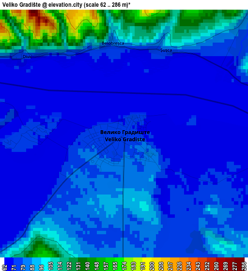
Below is the Elevation map of Veliko Gradište, which displays elevation range with different colors. Scale of the first map is from 62 to 286 m (203 to 938 ft) with average elevation of 83.2 meters (=273 ft) [note 1]
These maps also provides idea of topography and contour of this city, they are displayed at different zoom levels. More info about maps, scale and edge coordinates you can find below images.
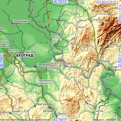
| \ | Map #1 | Topo.Map |
| Scale [m] | 62..286 m | × |
| Scale [ft] | 203..938 ft | × |
| Average | 83.2 m = 273 ft | × |
| Width | 6.94 km = 4.3 mi | 222 km = 137.9 mi |
| Height | 6.94 km = 4.3 mi | 222 km = 137.9 mi |
| ↑Max Latitude | 44.794484° | 45.75313° |
| Latitude at center | 44.76329° | 44.76329° |
| ↓Min Latitude | 44.732079° | 43.75619° |
| ← Min Longitude | 21.472515° | 20.11021° |
| Longitude center | 21.51646° | 21.51646° |
| →Max Longitude | 21.560405° | 22.92271° |
Nearby cities:
Cities around Veliko Gradište sort by population:
• Požarevac elevation 80 m
30.4 km,  238°
238°
• Bela Crkva 82 m
16.9 km,  332°
332°
• Uljma 87 m
42.1 km,  317°
317°
• Izbište 95 m
39 km, 317°
• Duboka 229 m
33 km,  144°
144°
• Golubac 73 m
15.3 km, 143°
• Radenka 364 m
28 km, 135°
• Ševica 209 m
32.7 km,  149°
149°
• Kuštilj 88 m
32.1 km,  340°
340°
• Turija 137 m
28.5 km,  160°
160°
• Kučevo 163 m
34 km, 159°
• Malo Crniće 85 m
29.4 km,  218°
218°
Multilingual:
 En español:
Veliko Gradište elevación 74 m.
 En France:
Veliko Gradište élévation 74 m.
 Auf Deutsch:
Veliko Gradište höhe über dem Meeresspiegel ist 74 m.

Sources and notes:
- [note 1] Map square and city borders are not equal. Map elevation data is calculated only from area inside that square.
- [src 1] Elevation data from geonames database provided with same terms of usage.
- [src 2] The elevation map of Veliko Gradište is generated using elevation data from NASA's 3 arcsec (90m) resolution SRTM data.
- [src 3] Base (background) map © OpenStreetMap contributors tiles are generated by Geofabrik and OpenTopoMap.
Copyright & License:
This Veliko Gradište Elevation Map is licensed under CC BY-SA. You may reuse any part from this page, if you give a proper credit by linking to this URL:
 More info on terms of use page.